MyTopo
Hialeah SW Florida US Topo Map
Couldn't load pickup availability
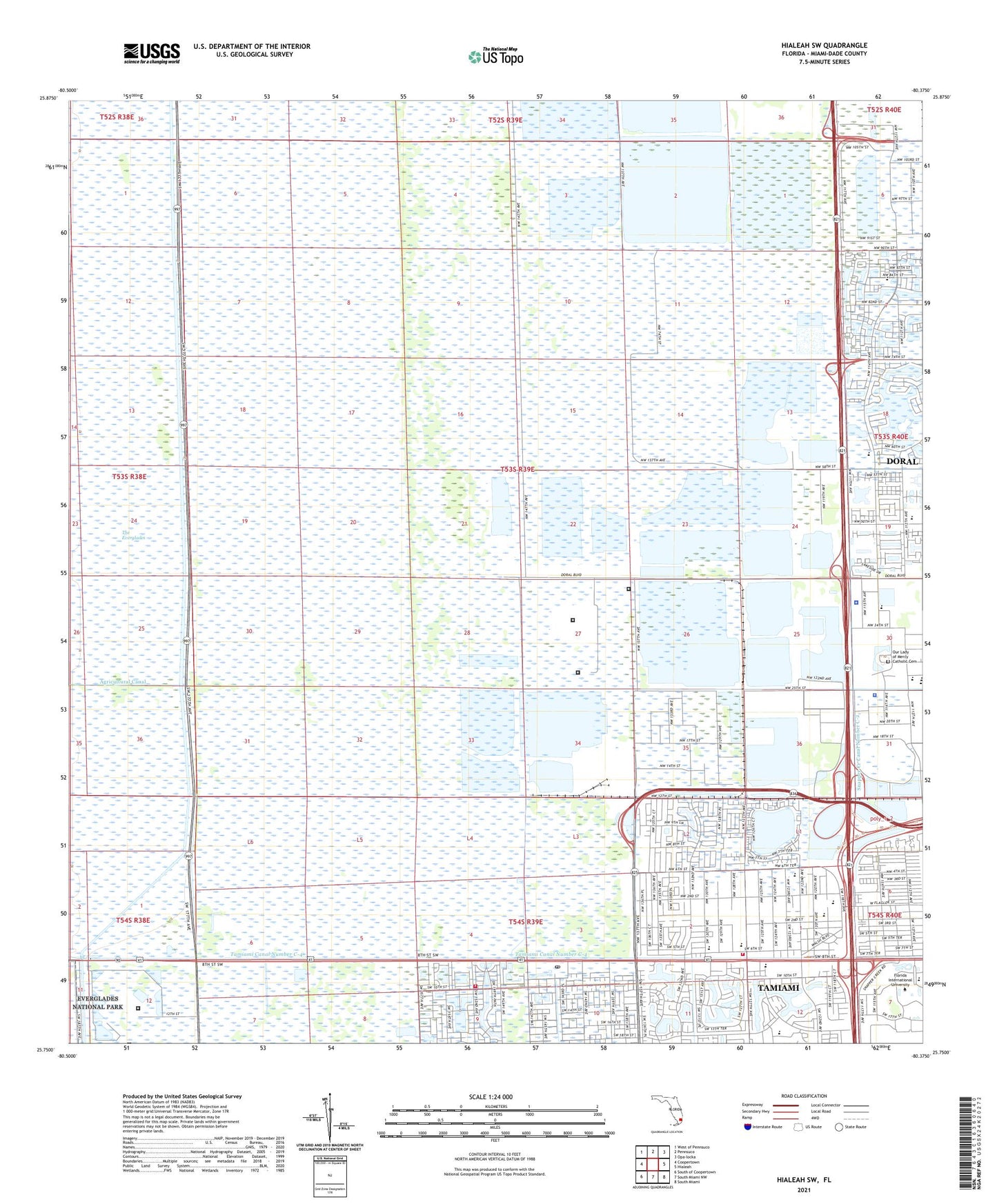
2024 topographic map quadrangle Hialeah SW in the state of Florida. Scale: 1:24000. Based on the newly updated USGS 7.5' US Topo map series, this map is in the following counties: Miami-Dade. The map contains contour data, water features, and other items you are used to seeing on USGS maps, but also has updated roads and other features. This is the next generation of topographic maps. Printed on high-quality waterproof paper with UV fade-resistant inks.
Quads adjacent to this one:
West: Coopertown
Northwest: West of Pennsuco
North: Pennsuco
Northeast: Opa-locka
East: Hialeah
Southeast: South Miami
South: South Miami NW
Southwest: South of Coopertown
This map covers the same area as the classic USGS quad with code o25080g4.
Contains the following named places: Belen Jesuit School, Bugs Bunny Day Care Center, Chinese Baptist Church, City of Sweetwater, Colonial Village Shopping Center, Columbia Behavioral Health Center, Conchita Espanosa Academy, Coral Park Center, Dade-Broward Levee, Dolphin Mall, Dolphin Mall Shopping Center, Doral Middle School, Doral Palms Hospital, Dr Carlos J Finlay Elementary School, Early Start Christian Day Care Center, El Redentor Day Care, Eugenia B Thomas K - 8 Center, Father Felix Varela Post Office, Florida Department of Corrections South Florida Reception Center, Florida Department of Corrections South Florida Reception Center South, Florida Department of Law Enforcement Miami Regional Operations Center, Florida International University, Francis S Taylor Wildlife Management Area, Iglesia Bautista de Filadelfia, Iglesia Church, International Gardens Park, International Plaza Shopping Center, Interplaza Shopping Center, Just Kids Day Care Center, Kendale Lakes-Tamiami Division, Krome Avenue Boat Ramp, Krome North Service Processing Center, Lil Abner Mobile Home Park, Marjory Stoneman Douglas Elementary School, Metrowest Detention Center, Miami - Dade College Police Department - MDC West Campus, Miami - Dade County Police Department - Communications Bureau, Miami - Dade County Tamiami Fire Rescue Station 58, Miami - Dade County Trail Fire Rescue Station 61, Miami International Mall, Miccosukee Police Department Krome Substation, Midway Mall, My Little World Day Care Center, National Hurricane Center, Our Lady of Mercy Catholic Cemetery, Paul W Bell Middle School, Religiosas Teatinas Day Care Center, Ronselli Park, Schortemeyers Triangle, Somerset Academy Charter High School, Somerset Academy Charter Middle School, South Florida Evaluation and Treatment Center, South Florida Military Academy, South Florida Reception Center, Sweetwater Center, Sweetwater City Youth Center, Sweetwater Police Department, Tamiami, Tamiami Census Designated Place, Tamiami Regional Park, Tamiami Trail Park, Tamiami Trail Shops, The Big Bunny Day Care Center, Trail Glade Tower, Trail Glades Range, Tutor Time Child Care Learning Center, University Lakes Mobile Home Park, University Lakes Shopping Center, Vann Academy, WACC - AM (Hialeah), Wesley Matthews Elementary School, WFBA-AM (Miami), WMYM - AM (Miami), WQBA-AM (Miami), WRFM-AM (Hialeah), WSUA-AM (Miami), WWFE-AM (Miami), ZIP Codes: 33178, 33182, 33184