MyTopo
Ocala East Florida US Topo Map
Couldn't load pickup availability
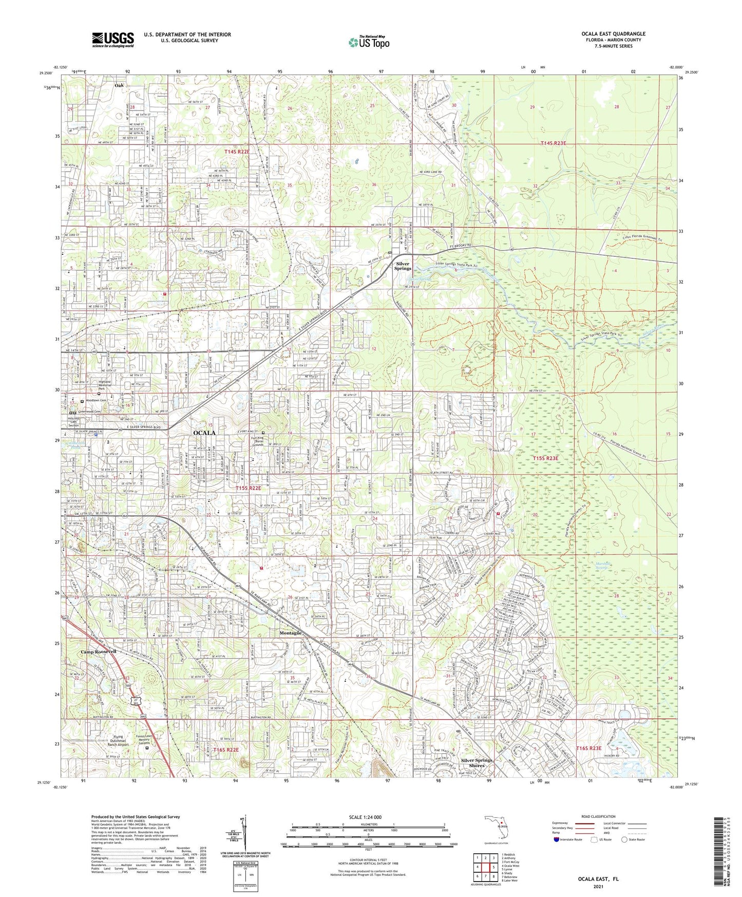
2024 topographic map quadrangle Ocala East in the state of Florida. Scale: 1:24000. Based on the newly updated USGS 7.5' US Topo map series, this map is in the following counties: Marion. The map contains contour data, water features, and other items you are used to seeing on USGS maps, but also has updated roads and other features. This is the next generation of topographic maps. Printed on high-quality waterproof paper with UV fade-resistant inks.
Quads adjacent to this one:
West: Ocala West
Northwest: Reddick
North: Anthony
Northeast: Fort McCoy
East: Lynne
Southeast: Lake Weir
South: Belleview
Southwest: Shady
This map covers the same area as the classic USGS quad with code o29082b1.
Contains the following named places: Abiding Hope E V Lutheran Church, Abundant Harvest Ministries, Apostolic Christian Church, Appleton Museum of Art, Arbors of Ocala Mobile Home Park, ARC Birth - 22 School, Ascencion Lutheran Church, Bible Baptist Church, Blue Skies Estates Mobile Home Park, Booster Stadium, Brick City Park Stadium, Cala Springs Mobile Home Park, Caldwells Pond, Camp Roosevelt, Central Baptist Church, Central Christian Church, Central Church of Christ, Chelsea Square, Cherry Hill Mobile Home Park, Christ Community Church of Ocala, Christian Church Conference Center, Church at the Springs, Church of Christ, Church of Christ Central, Church of God Sabbath Observed, Community of Christ, Country Aire Mobile Home Park, Craft Travel Trailer Park, Daystar Worship Center, Discovery Science and Outdoor Center, Downtown Baptist Church, First Assembly Christian School, First Assembly of God Church, First Baptist Church of Ocala, First Baptist Church of Silver Spring Shores, First Baptist Church of Silver Springs, First Christian Church, First Church of Christ Scientist, First Church of the Nazarene, First Free Will Baptist Church, First Pentecostal Church, First United Methodist Church, Florida Highway Patrol - Ocala Troop B, Florida School for Girls, Flying Dutchman Ranch Airport, Forest High School, Forest High School Stadium, Forest Lawn Memory Gardens, Fort King, Fort King Baptist Church, Fort King Burial Grounds, Fort King Middle School, Fort King Presbyterian Church, Forty East Shopping Center, Gerald Eagle Electric Substation, Glorious Hope Christian Life Center, Grace Episcopal School, Grace Presbyterian Church, Greenwood Cemetery, Harvest Fellowship Bible Church, Highland Christian School, Highland Memorial Park, Highlands Baptist Church, Hillcrest Cemetery Section, Hillcrest School, Huntington, Islamic Center of Ocala, Kingdom Hall of Jehovahs Witnesses, Kingdom Hall of Jehovah's Witnesses, Liberty Temple Christian Mission Apostolic Church, Life Tabernacle, Lindale Mobile Home Park, Living Hope Community Church, Magnolia Park Shopping Center, Maplewood Elementary School, Maricamp, Maricamp Post Office, Maricamp Road Branch Post Office, Marion County, Marion County Family YMCA, Marion County Fire Rescue Station 28 Rolling Green, Marion County Museum of History, Marion County Public Library - Main Branch, Marion County Sheriff's Office-Silver Springs District, Marion County-McPherson Governmental Complex, Marion Technical Institute, McFall Station, Memorial Baptist Church, Memorial Christian School, Mishkan Messianic Congregation, Missionary Church, Montague, Montessori PreSchool, Montessori School, Moss Bluff Baptist Church, Mount Canaan Missionary Baptist Church, Nautilus Trailer Park, New Covenant Worship Center, New Hope Community Church, New Horizon Christian Center, New Testament Baptist Church, Northside Missionary Baptist Church, Oak Griner Christian School, Oakbrook Plaza, Oakcrest Baptist Church, Oakcrest Elementary School, Oakmont School, Ocala Christian Academy, Ocala Division, Ocala Fire and Rescue Station 2, Ocala Fire and Rescue Station 5, Ocala Grace Brethren Church, Ocala Highlands School, Ocala Junior Academy, Ocala Police Department, Ocala Police Department East District, Ocala Seventh Day Adventist Church, Ocala Sewage Disposal Plant, Ocala Shopping Center, Ocala Springs Baptist Church, Ocala Springs Elementary School, Ocala Water Reclamation Facility 2, Ocala-Marion County Veterans Memorial Park, Our Lady of the Springs Catholic Church, Our Saviour Lutheran Church, Pelican Sound Golf and River Club, Perry Golf and Country Club, Phoenix School, Pine Island Ridge Country Club, Robert F Ritterhoff Park, Rolling Greens Mobile Home Park, Rolling Greens Mobile Home Park Library, Saint Basil the Great Eastern Orthodox Church, Saint George Anglican Church, Saint John Lutheran School, Saint Jude Catholic Church, Saint Mary's Baptist Church, Saint Matthew's Lutheran Church, Saint Patricks Episcopal Church, Saint Pauls Missionary Baptist Church, Saint Paul's United Methodist Church, Sanctuary of Ocala, Sandy Hill Academy, Seminole Electric Cooperative Substation, Shree Krishna Manbir Incorporated, Silver Oaks Community Center, Silver River Museum and Environmental Education Center, Silver River State Park, Silver Springs, Silver Springs Camp, Silver Springs Census Designated Place, Silver Springs Post Office, Silver Springs Water Tower, Six Gun Plaza, Skylark Plaza, South Ocala Baptist Church, South Ocala Elementary School, Southeast Side Mobile Home Park, Spanish Oaks Mobile Home Park, Spanish Palm Estates Mobile Home Park, Sunshine and Light, Temple B'Nai Darom, The Appleton Museum of Art, The Church of God, The Church of Jesus Christ of Latter Day Saints, Trinity Baptist Church, Trinity Lutheran Church, Twin Oaks Mobile Home Park, U S Army Reserve Center, Unitarian Universalist Fellowship of Marion, Unity of Ocala Church, Wagon Wheel Mobile Home Park, Ward - Highlands Elementary School, WHIJ-FM (Ocala), Wings of Faith Fellowship Church, WMMZ-FM (Ocala), WMOP-AM (Ocala), Woodland Place Church of Christ, Woodlawn Cemetery, Woodside Baptist Church, Wyomina Park Baptist Church, Wyomina Park Elementary School, ZIP Code: 34470