MyTopo
Palmetto Florida US Topo Map
Couldn't load pickup availability
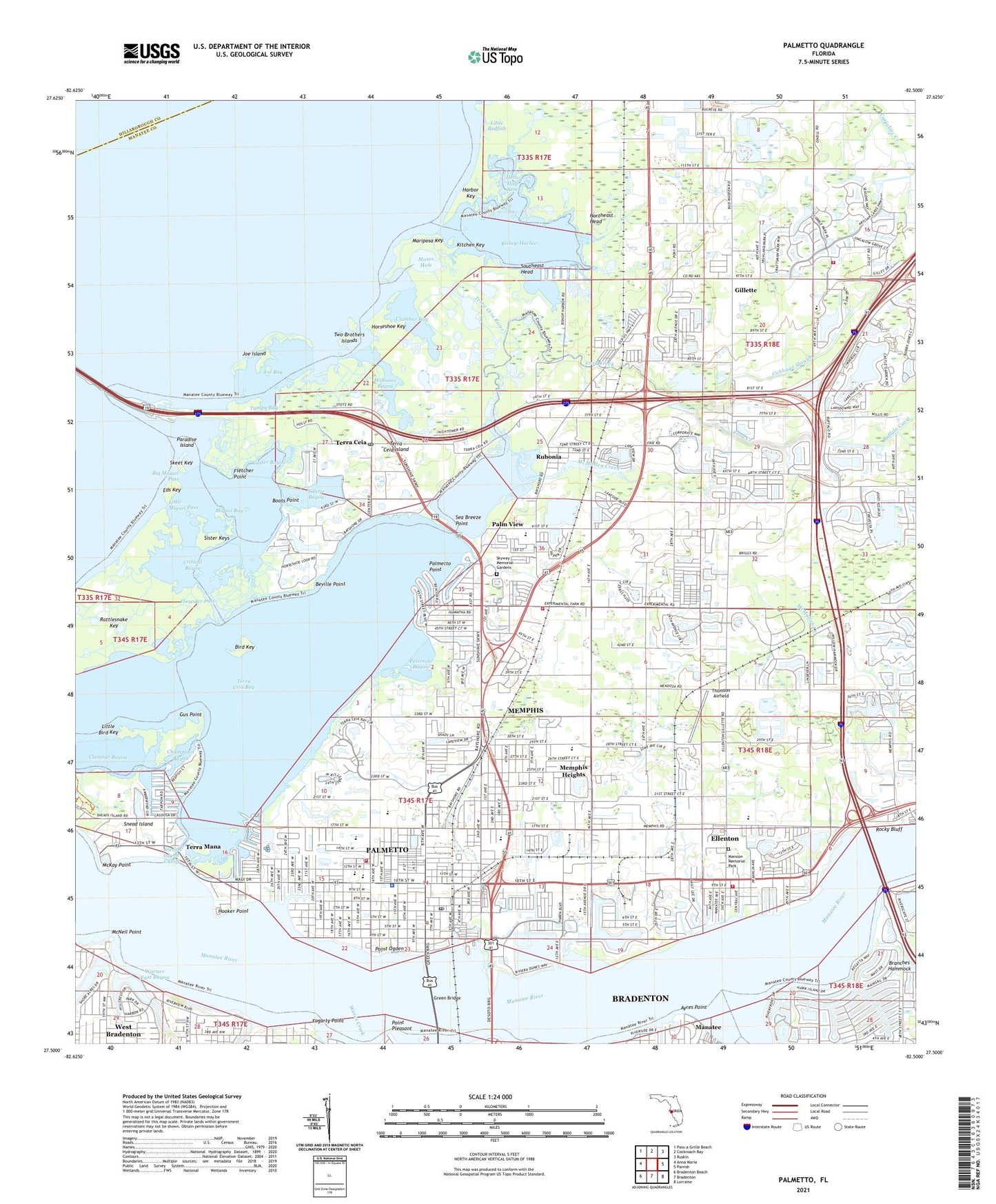
2024 topographic map quadrangle Palmetto in the state of Florida. Scale: 1:24000. Based on the newly updated USGS 7.5' US Topo map series, this map is in the following counties: Manatee, Hillsborough. The map contains contour data, water features, and other items you are used to seeing on USGS maps, but also has updated roads and other features. This is the next generation of topographic maps. Printed on high-quality waterproof paper with UV fade-resistant inks.
Quads adjacent to this one:
West: Anna Maria
Northwest: Pass-a-Grille Beach
North: Cockroach Bay
Northeast: Ruskin
East: Parrish
Southeast: Lorraine
South: Bradenton
Southwest: Bradenton Beach
This map covers the same area as the classic USGS quad with code o27082e5.
Contains the following named places: Alpha-Omega Private School, Ayres Point, Beville Point, Big Miguel Pass, Bird Key, Bishop Harbor, Blackburn Elementary School, Boots Point, Braden River, Cabbage Slough, Cedar Drain, Champlain Bayou, Church of Christ 43rd Street, City of Palmetto, Clambar Bay, Clambar Bayou, Critical Bayou, Critical Creek, Custer Bayou, Eds Key, Ellenton, Ellenton Census Designated Place, Faith Deliverance Church, First United Methodist Church of Palmetto, Fletcher Point, Flounder Pass, Fogarty Point, Frog Creek, Fullers Earth, Gillette, Gillette Station Railroad Station, Green Bridge, Gus Point, Harbor Key, Hells Half Acre, Holy Cross Church, Hooker Point, Horseshoe Key, Joe Bay, Joe Island, Judah P Benjamin Confederate Memorial at Gamble Plantation Historic State Park, Kitchen Key, Lemon Spur Railroad Station, Lincoln Middle School, Little Bird Key, Little Miguel Pass, Little Redfish, Manatee Agricultural Center, Manatee County Sheriff's Office, Manavista, Mansion Memorial Park, Mariposa Key, McKay Point, McMullen Creek, McNeil Point, Memphis, Memphis Census Designated Place, Memphis Heights, Miguel Bay, Miracle Hole Church, Moses Hole, North River Fire District Station 1, North River Fire District Station 2, North River Fire District Station 3, North River Fire District Station 5, Northeast Head, Palm View, Palm View Elementary School, Palmetto, Palmetto Assembly of God, Palmetto Division, Palmetto Elementary School, Palmetto High School, Palmetto Junction, Palmetto Plaza, Palmetto Point, Palmetto Police Department, Palmetto Post Office, Palmetto Village Shopping Center, Paradise Island, Pentecostal of Faith Church, Peterson Bayou, Point Ogden, Point Pleasant, Rattlesnake Key, Richfield Railroad Station, Rocky Bluff, Rubonia, Schooley Station Railroad Station, Sea Breeze Point, Sister Keys, Skeet Key, Skyway Memorial Gardens, Snead Island, Snead Island Cutoff, Southeast Head, Southern Dolomite Company Railroad Station, Spiritual House of Praise, Terra Ceia, Terra Ceia Bay, Terra Ceia Island, Terra Ceia Junction, Terra Ceia Post Office, Terra Ceia River, Terra Mana, Thomson Airfield, Tillette Bayou, Tillman Elementary School, Two Brothers Islands, Wares Creek, Warner East Bayou, Warner West Bayou, WBRD-AM (Palmetto), WDUV-FM (Bradenton), West Bradenton, West Bradenton Census Designated Place, Williams Bayou, WKLV-AM (Bradenton), ZIP Codes: 34221, 34222