MyTopo
Chamblee Georgia US Topo Map
Couldn't load pickup availability
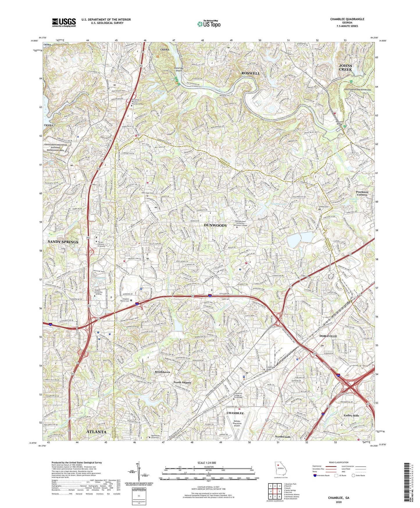
2024 topographic map quadrangle Chamblee in the state of Georgia. Scale: 1:24000. Based on the newly updated USGS 7.5' US Topo map series, this map is in the following counties: Fulton, DeKalb, Gwinnett, Cobb. The map contains contour data, water features, and other items you are used to seeing on USGS maps, but also has updated roads and other features. This is the next generation of topographic maps. Printed on high-quality waterproof paper with UV fade-resistant inks.
Quads adjacent to this one:
West: Sandy Springs
Northwest: Mountain Park
North: Roswell
Northeast: Duluth
East: Norcross
Southeast: Stone Mountain
South: Northeast Atlanta
Southwest: Northwest Atlanta
This map covers the same area as the classic USGS quad with code o33084h3.
Contains the following named places: Amwiler Industrial Park, Austin Elementary School, Ball Mill Creek, Bay Colony Industrial Park, Berwicke, Blackburn Park, Brookhaven, Buchanan, Buford Junction Shopping Center, Cadence Dam, Cadence Lake, Cambridge Estates, Cambridge Shopping Center, Cambridge Square, Cary Reynolds Elementary School, Cedar Ridge Plaza Shopping Center, Chamblee, Chamblee Antique Mall, Chamblee City Park, Chamblee Commercial Center Shopping Center, Chamblee High School, Chamblee Middle School, Chamblee Plaza Shopping Center, Chamblee Station, Chamblee-Doraville Division, Charter Brook Hospital, Chattahoochee River National Recreation Area, Chattahoochee Station, Chelsea Park, Cherokee Country Club, Chesnut Elementary School, Chestnut Forest, Children's Health Care of Atlanta at Scottish Rite, Chinatown Shopping Center, City of Chamblee, City of Doraville, City of Dunwoody, City of Sandy Springs, Crestwicke, Crooked Creek, Deerfield, DeKalb County Cultural Arts School, DeKalb County Police North Precinct Heliport, DeKalb County Water Works, DeKalb County Water Works Dam, DeKalb Highlands, Dekalb-Peachtree Airport, Derby Hill, Doraville, Doraville County Health Center, Doraville Driver Education Center, Doraville Plaza Shopping Center, Doraville Shopping Center, Doraville Station, Dunwoody, Dunwoody Census Designated Place, Dunwoody Club Forest, Dunwoody Corners, Dunwoody Country Club, Dunwoody Hall Shopping Center, Dunwoody Heights, Dunwoody High School, Dunwoody Knoll, Dunwoody Park, Dunwoody Village Shopping Center, Dunwoody West, East Lake Meadows Health Center, Edison Cemetery, Elmside Village, Elton Estates, Embry Hills, Fairfield, Flowers Park, Fontainbleau Forest, Forest Valley, Forestdale Estates, Four Oaks, Fouts Corner, Fox Hollow, Fridays Plaza Shopping Center, Georgetown Shopping Center, Georgia Retardation Center, Gergia Perimeter College Dunwoody Campus, Hammond, Hammond Exposition, Hammond Park, Happy Hollow, Hartrampf Heliport, Hidden Branches, High Point Elementary School, Highpoint Forest, Hightower Elementary School, Holcomb Bridge, Holcomb Corners Shopping Center, Honeysuckle Park, Horse Shoe Bend Lake, Horse Shoe Bend Lake Dam, Horse Shoe Bend Lake South, Horse Shoe Bend Lake South Dam, Horseshoe Bend, Horseshoe Bend Golf Course, Humphries, Huntley Hill, Huntley Hills Elementary School, Huntridge Shopping Center, Island Bar Shoals, Jim Cherry School, Johnson Ferry Elementary School, Kingsley Elementary School, Kingsley Lake, Kingsley Lake Dam, Kittredge Magnet Elementary School, Korean Shopping Center, Lake Villas, Lake Windsor Dam, Laurelwood Park, Littlebrooke Farm, Lockridge Forest, Lynnwood Park Health Center, Lynwood Park School, Manning Farms, Meadowlake, Mill Glen, Montgomery Elementary School, Morgan Falls Heliport, Morgan Falls School, Mount Vernon Lake, Mount Vernon Shopping Center, Mount Vernon Springs, Murphy Cadler Park, Murphy Chandler Dam, Murphy Chandler Lake, Neely Farm, New Hope Cemetery, North DeKalb Mental Health Center, North DeKalb Stadium, North Fork Nancy Creek, North Hills Shopping Center, North Peachtree Woods, North Point, North River Village Shopping Center, North Springs High School, North Springs Shopping Center, Northeast Atlanta Industrial Park, Northridge Lake, Northridge Lake Dam, Northridge Shopping Center, Northside Hospital, Northside Hospital Heliport, Northwoods, Northwoods Creek, Northwoods Plaza Shopping Center, Oak Point, Oakcliff Elementary School, Occupational Education Center North, Orchard Park Shopping Center, Our Lady of the Assumption School, Patronis Lake, Patronis Lake Dam, Peachford Hospital, Peachtree, Peachtree Corporate Center, Peachtree Golf Course, Peachtree Middle School, Peppertree Lake, Peppertree Lake Dam, Perimeter Business Park, Perimeter Mall Shopping Center, Perimeter McCall Business Park, Perimeter Village Shopping Center, Pinetree Shopping Center, Pinetree West Shopping Center, Prosperity Cemetery, Redfield, Ridgeview Forest, Ridgeview Middle School, River Bluff, River Exchange Shopping Center, Rivergate, Rivermont Golf Course, Rivermont Square Shopping Center, Riversong, Saint Andrews, Saint Joseph's Hospital of Atlanta, Sandy Springs Middle School, Sanford Brown Institute, Sara Lake Estates, Scott Candler Reservoir Dam, Scottish Rite Childrens Hospital Heliport, Scottish Rite Heliport, Sequoyah High School, Sexton Woods Psychoeducational Center, Shallowford Community Hospital, Shenandoah, Shops at Morgan Falls Shopping Center, Silver Lake, Silver Lake Dam, Spalding Centre Shopping Center, Spalding Hills, Spalding Place Shopping Center, Spalding Woods Village Shopping Center, Springfield, Starlight Hills, Stephen Martin Cemetery, The Mill Centre Shopping Center, The Shops at Dunwoody Shopping Center, Trailridge, Valley View, Vanderlyn Elementary School, Verdon Forest, Village Mill, Village North, Waterford, WCNN-AM (North Atlanta), Webb School, Westover, Wickford, Williamsburg at Dunwoody Shopping Center, Wilson Mill, Windhaven, Windsor at Peachtree, Windsor Heights, Windwood, Windwood Hollow Park, Winters Village Shopping Center, Withmere, Woodland Elementary School, Wynterhall, ZIP Codes: 30319, 30338, 30340, 30341, 30346, 30350, 30360