MyTopo
Mountain Park Georgia US Topo Map
Couldn't load pickup availability
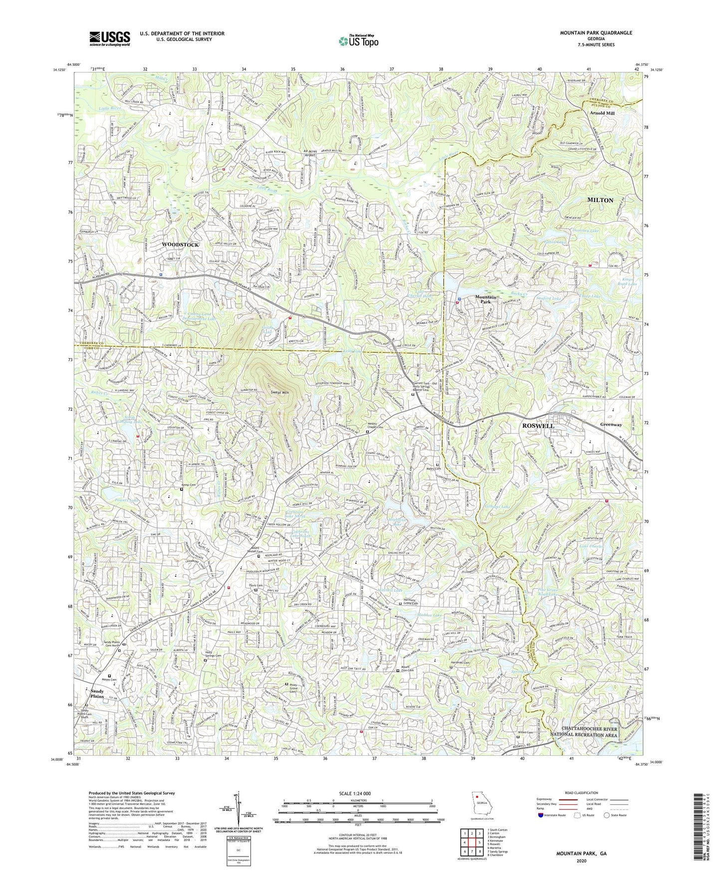
2024 topographic map quadrangle Mountain Park in the state of Georgia. Scale: 1:24000. Based on the newly updated USGS 7.5' US Topo map series, this map is in the following counties: Cobb, Cherokee, Fulton. The map contains contour data, water features, and other items you are used to seeing on USGS maps, but also has updated roads and other features. This is the next generation of topographic maps. Printed on high-quality waterproof paper with UV fade-resistant inks.
Quads adjacent to this one:
West: Kennesaw
Northwest: South Canton
North: Canton
Northeast: Birmingham
East: Roswell
Southeast: Chamblee
South: Sandy Springs
Southwest: Marietta
This map covers the same area as the classic USGS quad with code o34084a4.
Contains the following named places: Addison Elementary School, Air Acres Airport, Ansley Forest, Applewood, Arnold Mill, Arnold Mill Elementary School, Badger Creek, Bethel Church, Bishop Lake Dam, Blessed Trinity Catholic High School, Bluff Creek, Boulder Creek, Bramble Oak, Brookfield West, Brookfield West Golf Course, Carl Harrison Park, Carlisle Acres, Carriage Lakes, Centre at Woodstock Shopping Center, Chaffin Road Lake, Chattahoochee Technical College Mountain View, Cherecobb Estates, Cherokee Christian School, Cherokee County Fire Department Station 7, Chestnut Ridge Church, Chimney Lakes, Christ United Methodist Church, City of Mountain Park, Cobb County Fire and Emergency Services Station 14, Cobb County Fire and Emergency Services Station 15, Cobb County Fire and Emergency Services Station 25, Cochrans Lake North, Cochrans Lake North Dam, Cochrans Lake South, Cochrans Lake South Dam, Colemans Bluff, Colemans Landing, Colony Center, Colony Land Development Lake, Colony Land Development Lake Dam, Colony Springs, Congregation Beth Hallel, Copper Sandy Creek, Coventry Downs, Coventry Green, Creek Hollow South, Creek View, Crossroad Church, Davis Cemetery, Davis Elementary School, Deerchase, Dominey Lake, Dominey Lake Dam, Driftwood Forest, Driftwood Station, Dupree Park, East Cobb Church of Christ, Emerson Unitarian Universalist Congregation, Farmington, Fellowship Bible Church, Fellowship Christian High School, Fellowship Christian School, Fountain Lake Mobile Home Park, Fulton Dam, Fulton Lake, Garrards Crossing, Garrett Cemetery - Old Holly Springs Baptist Cemetery, Garrett Lake, Garrison Mill Elementary School, Gilhams Lake, Gilhams Lake Dam, Glenforest, Gordy Lake, Greenway, Hardman Cemetery, Hardman Place, Harmony Grove Cemetery, Harmony Grove Church, Heartwood, Hedgerow, Hidden Lake Farms Heliport, High Meadows School, Highland Colony, Highland Lake, Hightower Trail Middle School, Holly Farm Airport, Holly Oaks, Holly Springs Cemetery, Holy Trinity Church, Hunters Mill, Jordan Lake Baptist Church, Keheley Elementary School, Kelly Lake, Kelly Lake Dam, Kemp Cemetery, Kings Road Lake, Kings Road Lake Dam, Knotts Landing, Knotts Pointe, Lake Charles, Lake Charles Dam, Lake Cherful, Lake Cherful Dam, Lassiter High School, Litchfield Hundred, Little River Church, Little River Crossing, Little River Elementary School, Little River North, Little River Number 39 Dam, Little River Number 40 Dam, Little River South, Mabry Cemetery, Mabry Middle School, Maddox Lake, Marlanta, Mayes Cemetery, Mill Creek Crossing, Mill Creek Middle School, Misty Mountain, Mitchell Lake, Mitchell Lake Dam, Mount Beulah Cemetery, Mount Gilead Church, Mount Oliver Church, Mount Zion Cemetery, Mount Zion Church, Mountain Creek, Mountain Park, Mountain Park City Hall, Mountain Park Elementary School, Mountain Park Fire Department, Mountain Park Plaza Shopping Center, Mountain Park Police Station, Mountain Ridge, Mountain View Elementary School, Murdock Elementary School, New Home Church, Noble World Montessori School, North Forest, North Landing Lake, North Landing Lake Dam, North Point, Northeast Cobb Division, Northside Christian Church, Northside Church of Christ, Nowlin Hall, Oak Chase, Open Door Fellowship Church, Park Place Estates, Pilgrimage Church, Pine Grove Road Lake, Pine Grove Road Lake Dam, Piney Grove Baptist Church, Piney Grove Cemetery, Pioneer Crossing, Plantation North, Plantation Place, Pope High School, Powers Lake, Powers Lake Dam, Praise Cathedral, Primitive Baptist Church, Qeen of Angels Catholic School, River Oaks, River Ridge High School, Riverchase, Rock Springs Church, Rocky Creek, Rocky Mount Elementary School, Rocky Springs, Roswell Church of Christ, Roswell Corners Shopping Center, Roswell Fire Department Station 3, Roswell Fire Department Station 6, Roswell High School, Roswell Oaks, Russell Plantation, Sandy Plains, Sandy Plains Baptist Church, Sandy Plains Cemetery North, Sandy Plains Cemetery South, Sandy Plains Centre Shopping Center, Sandy Plains Park, Sandy Plains Shopping Center, Sandy Plains Village Center II Shopping Center, Sanford Lake, Shallow Ford Shopping Center, Shallowford Corners Shopping Center, Shallowford Falls Elementary School, Shallowford Falls School, Shallowford Falls Shopping Center, SHallowford Shopping Center, Simpson Middle School, Southern Oaks, Sprayberry High School, Sprayberry Post Office, Spring Lake, Stanford Lake, Sturbridge Village, Sunlight Church, Sunny Brook, Swanson Heights, Sweat Mountain, Sweat Mountain Lookout Tower, Sweat Mountain Park, Sweet Apple Crossing, Tharp Lake, Tharp Lake Dam, The Church of Jesus Christ of Latter Day Saints, The Corners Shopping Center, The Plains, Tomahawk, Trickum Hills, Tritt Elementary School, Upland Estates, Vandiver Heights, Village Montessori School, Waterfront, Wesley Chapel, Wesley Chapel Cemetery, Westfield, Westminster Japanese Church, Wildwood Springs, Wiley Bridge Junction, Willeo Cemetery, Willeo Church, Willow Tree, Windrush, Woodstock Crossing Shopping Center, Woodstock Fire Department Station 10, Woodstock Police Department, ZIP Codes: 30062, 30075, 30188