MyTopo
Fort Benning Georgia US Topo Map
Couldn't load pickup availability
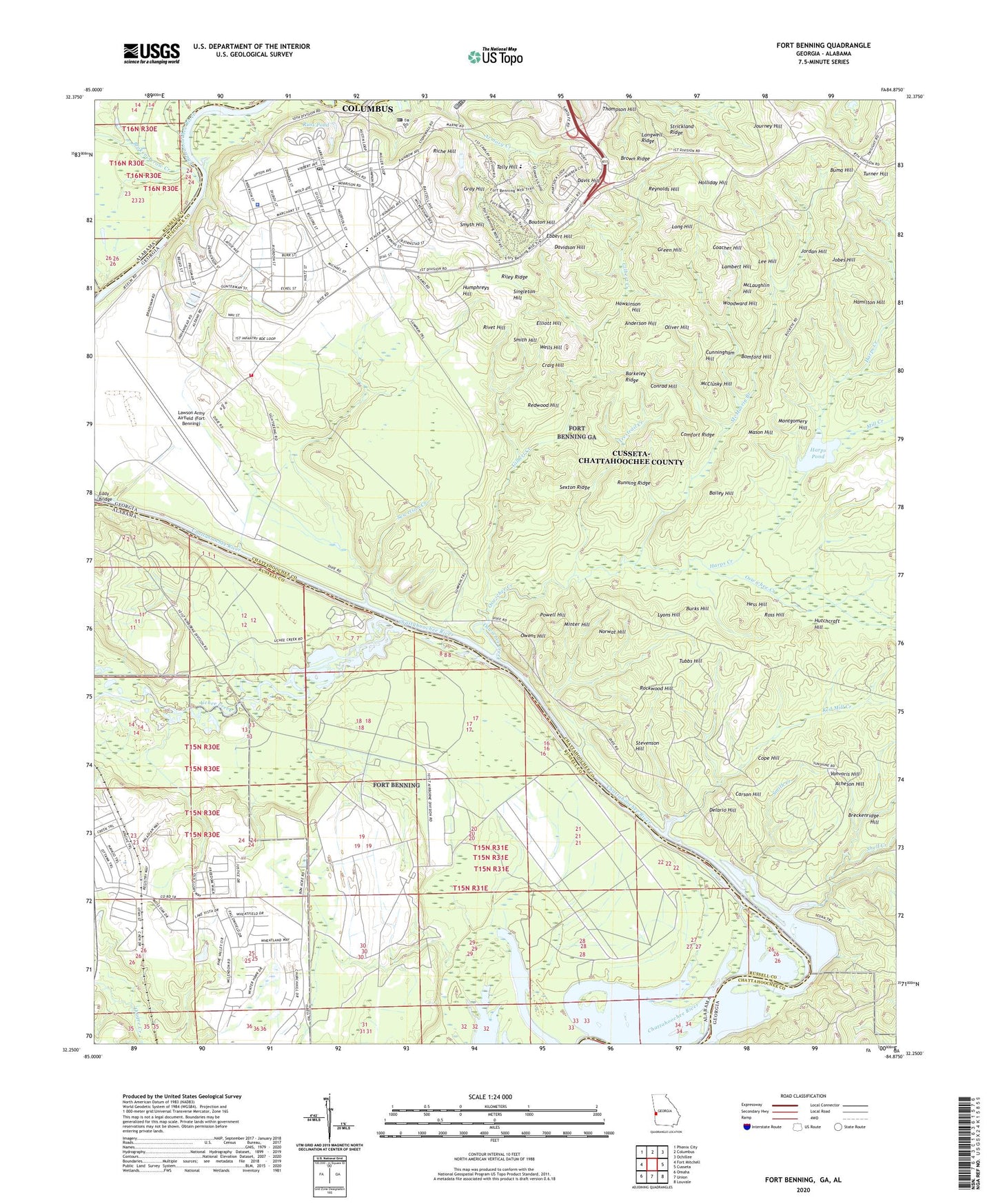
2024 topographic map quadrangle Fort Benning in the states of Georgia, Alabama. Scale: 1:24000. Based on the newly updated USGS 7.5' US Topo map series, this map is in the following counties: Chattahoochee, Russell, Muscogee. The map contains contour data, water features, and other items you are used to seeing on USGS maps, but also has updated roads and other features. This is the next generation of topographic maps. Printed on high-quality waterproof paper with UV fade-resistant inks.
Quads adjacent to this one:
West: Fort Mitchell
Northwest: Phenix City
North: Columbus
Northeast: Ochillee
East: Cusseta
Southeast: Louvale
South: Union
Southwest: Omaha
This map covers the same area as the classic USGS quad with code o32084c8.
Contains the following named places: Acheson Hill, Anderson Hill, Apalatchukla, Bailey Hill, Barkeley Ridge, Bomford Hill, Bon Acre Landing, Bouton Hill, Bradley Landing, Breckenridge Hill, Broken Arrow Creek, Brown Ridge, Buma Hill, Burks Hill, Carson Hill, Chambers Landing, Chiaha, Coacher Hill, Cody Landing, Comfort Ridge, Conrad Hill, Cope Hill, Cottage Mills, Craig Hill, Cunningham Hill, Davidson Hill, Davis Hill, Delario Hill, Ebbert Hill, Edward White School, Elliott Hill, Faith School, Fort Benning, Fort Benning Mall Shopping Center, Fort Benning Military Police Department, Fort Benning Post Office, Fort Benning South Census Designated Place, Gilbert Creek, Good Hope Church, Gray Hill, Green Hill, Hamilton Hill, Hards Pond Dam, Harps Creek, Harps Pond, Hawkinson Hill, Herbert J Dexter School, Hess Hill, Holliday Hill, Humphreys Hill, Hutchcraft Hill, Jobes Hill, Jordan Hill, Journey Hill, Kasihta, Kawita Talahassi, Lambert Hill, Langwell Ridge, Lawson Army Airfield (Fort Benning), Lee Hill, Long Hill, Lyons Hill, Mason Hill, McClusky Hill, McDaniel Manor, McLaughlin Hill, McMurrin Branch, McMurrin Pond, Mill Creek, Minter Hill, Montgomery Hill, Norwat Hill, Oliver Hill, Osotchi, Oswichee Creek, Owens Hill, Patch Kindergarten, Powell Hill, Red Mill Creek, Redwood Hill, Reynolds Hill, Richard G Wilson School, Riche Hill, Riley Ridge, Rivet Hill, Rockwood Hill, Ross Hill, Running Ridge, Russ Pond, Sewelson Creek, Sexton Ridge, Shack, Shell Creek, Singleton Hill, Smith Creek, Smith Hill, Smyth Hill, Stevenson Hill, Strickland Ridge, Tally Hill, Thompson Hill, Trestrail Creek, Tubbs Hill, Turner Hill, Uchee Creek, Uchi, Vanvoris Hill, Wells Hill, Woodward Hill, Woolfolk, Yuchi, Yuchi Town Site, ZIP Code: 36856