MyTopo
Monroe Georgia US Topo Map
Couldn't load pickup availability
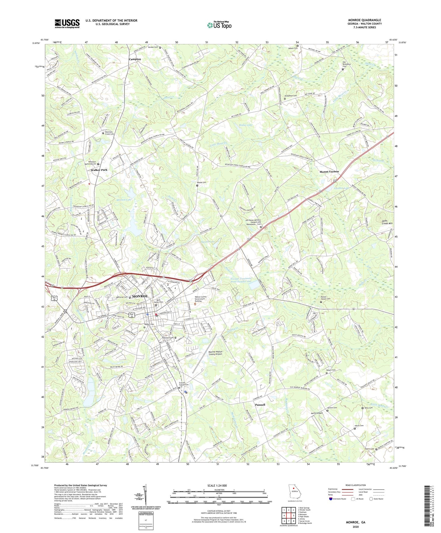
2024 topographic map quadrangle Monroe in the state of Georgia. Scale: 1:24000. Based on the newly updated USGS 7.5' US Topo map series, this map is in the following counties: Walton. The map contains contour data, water features, and other items you are used to seeing on USGS maps, but also has updated roads and other features. This is the next generation of topographic maps. Printed on high-quality waterproof paper with UV fade-resistant inks.
Quads adjacent to this one:
West: Between
Northwest: Bold Springs
North: Winder South
Northeast: Statham
East: High Shoals
Southeast: Rutledge North
South: Social Circle
Southwest: Jersey
This map covers the same area as the classic USGS quad with code o33083g6.
Contains the following named places: Adams Cemetery, Aerie Airport, Athens Technical College Walton County Campus, Aycock Cemetery, Aycock Lake, Aycock Lake Dam, Bethany Church, Blaine Street Elementary School, Breedlove Cemetery, Bucaneer Lake, Bucaneer Lake Dam, Calvary Church, Campton, Campton Church, Carver High School, Carver Middle School, City of Monroe, Cleaton, Club Park, Dennis Coker City Park, Durden Cemetery, East Church Street Historic District, East Marable Street Historic District, Eastview Cemetery, Everett Family Cemetery, First Baptist Church, First Methodist Church, First Methodist Episcopal Church South, Friendship Church, George Walton Academy, Georgia State Patrol Troop E Post 46 Monroe, Grubby Creek, Gunther Dam, Gunther Lake, Hammond Street Park, Harmony Church, Harris Cemetery, Hill Haven Memory Gardens And Mausoleum - Cemetery, Jacks Creek Mountain, Johnston Institute Grade School, Kelly Cemetery, Kingdom Hall Church, Little Shoal Creek, Love Tabernacle Church, Macedonia Church, Mathews Park, McDaniel Street Historic District, Memorial Cemetery, Memorial Library, Mitchell Lake, Mitchell Lake Dam, Monland Place Historic District, Monroe, Monroe Agricultural and Mechanical College, Monroe and Walton Mills Historic District, Monroe Area High School, Monroe City Hall, Monroe Commercial Historic District, Monroe Division, Monroe Elementary School, Monroe Fire Department, Monroe Golf and Country Club, Monroe Police Department, Monroe Post Office, Monroe-Walton County Airport, Mount Vernon, Mount Vernon Church, Mountain Creek Cemetery, Mountain Creek Church, North Broad Street Historic District, Nowell Recreation Center, Old Breedlove Cemetery, Pannell, Peters Cemetery, Prospect Church, Queen Cemetery, Ramey - Hester Cemetery, Rest Haven Cemetery, Saint Albans Episcopal Church, Saint Anna Chapel, Saint Stephens Methodist Church, Sewage Treatment Pond Number One, Sewage Treatment Pond Number One Dam, Sewage Treatment Pond Number Two, Sewage Treatment Pond Number Two Dam, South Broad Street Historic District, South Madison Avenue-Pannell Road Historic District, Spring Hill Church, Tabernacle Baptist Church, Walker Baptist Church, Walker Cemetery, Walker Park, Waller Dam, Waller Lake, Walton Career Academy, Walton County, Walton County Alternative Education and Walton Learning Center, Walton County Courthouse, Walton County Emergency Medical Services Unit 2, Walton County Fire Rescue Department Station 14, Walton County Hospital Heliport, Walton County Jail, Walton County Sheriff's Office, Walton Medical Center, Westlawn Memorial Cemetery, WKUN-AM (Monroe), WMLS-AM (Monroe), Woods Cemetery, Wrights Dam, ZIP Codes: 30655, 30656