MyTopo
Ewa Hawaii US Topo Map
Couldn't load pickup availability
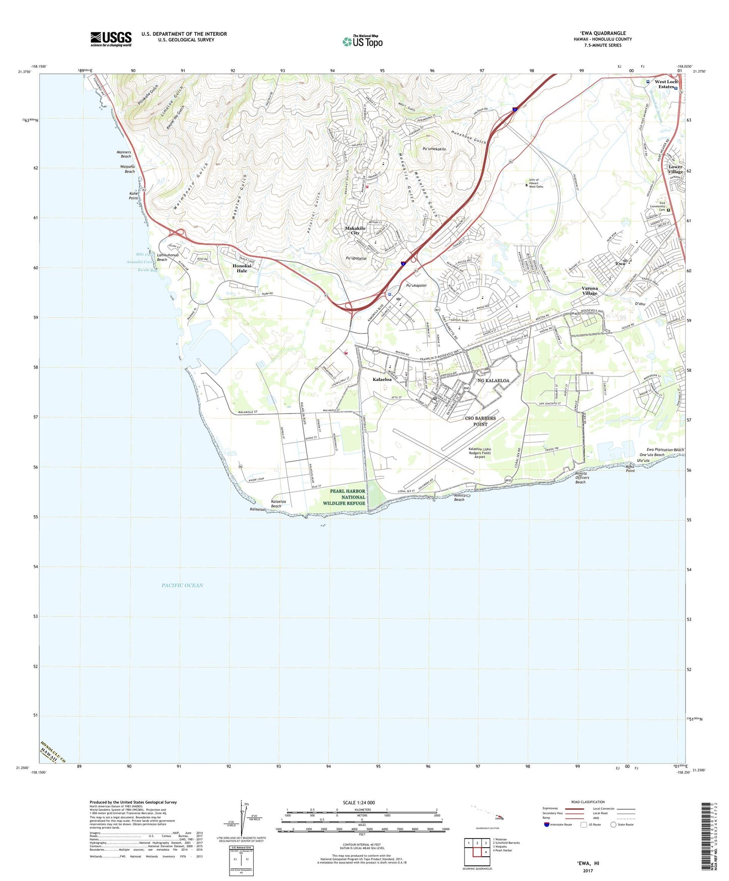
2024 topographic map quadrangle Ewa in the state of Hawaii. Scale: 1:24000. Based on the newly updated USGS 7.5' US Topo map series, this map is in the following counties: Honolulu. The map contains contour data, water features, and other items you are used to seeing on USGS maps, but also has updated roads and other features. This is the next generation of topographic maps. Printed on high-quality waterproof paper with UV fade-resistant inks.
Quads adjacent to this one:
Northwest: Waianae
North: Schofield Barracks
Northeast: Waipahu
East: Pearl Harbor
This map covers the same area as the classic USGS quad with code o21158c1.
Contains the following named places: Anianiku Cove, Awanui Gulch, Barbers Point Beach Park, Barbers Point Elementary School, Barbers Point Harbor, Barbers Point Housing Census Designated Place, Barbers Point Naval Air Station, Barbers Point Naval Air Station Post Office, Barbers Point Post Office, Battery Hatch, Browns Camp, Camp Malakole Military Reservation, Campbell Industrial Park, Coast Guard Air Station Barbers Point, East Kapolei, East Kapolei Census Designated Place, East Kapolei Hawaiian Home Land, 'Ewa, Ewa Community Cemetery, Ewa Community Church, Ewa Elementary School, 'Ewa Gentry, Ewa Gentry Census Designated Place, Ewa Mahiko Park, Ewa Marine Corps Air Station, Ewa Plantation Beach, Ewa Station Post Office, 'Ewa Villages, Ewa Villages Census Designated Place, Ewa Villages Golf Course, Fernandez Village, Fort Barrette, Friendship Bible Church, Hale O Ulu School, Hawaii Raceway Park, Hawaiian Electric Beach Park, Honokai Hale, Honolulu Emergency Medical Services Unit Makakilo, Honolulu Emergency Medical Services Unit Rapid Response, Honolulu Fire Department Station 35 Makakilo, Honolulu Fire Department Station 40 Kapolei, Honolulu Police Department Kapolei Station, Honouliuli, Honouliuli Wastewater Treatment Plant, Hunehune Gulch, Immaculate Conception Church, Kahe Beach Park, Kahe Point, Kahe Power Plant, Kahi Mohala Behavioral Health System, Kalaeloa, Kalaeloa Airport (John Rodgers Field), Kalaeloa Beach, Kalaeloa Census Designated Place, Kalaeloa Hawaiian Home Land, Kalaeloa Regional Park, Kalo'i Gulch, Kamokila Community Park, Kanehili Hawaiian Home Land, Kapolei, Kapolei Business Park, Kapolei Census Designated Place, Kapolei Community Park, Kapolei Hawaiian Home Land, Kapolei Neighborhood Park, Kapolei Post Office, Kapolei Regional Park, Kapolei Shopping Center, Ka'ula Bay, Kaupe'a Hawaiian Home Land, Keku Point, Keone'oio Gulch, Kipapa, Ko Olina Beach Park, Ko Olina Census Designated Place, Lanakila Baptist School - Junior and Senior High Campus, Lanikuhonua, Lanikuhonua Beach, Laulani Community Park, Limaloa Gulch, Lower Village, Makaiwa Beach Park, Makaiwa Gulch, Makakilo Census Designated Place, Makakilo City, Makakilo Community Park, Makakilo Elementary School, Makakilo Gulch, Makakilo Heights Neighborhood Park, Makakilo Neighborhood Park, Makalapa Gulch, Malakole Harbor, Maluohai Hawaiian Home Land, Manners Beach, Mauka Lani Elementary School, Mauka Lani Neighborhood Park, Maukalani Neighborhood Park, Milo Cove, Nimitz Beach, Nimitz Officers Beach, Ocean Pointe Census Designated Place, One'ula Beach, Oneula Beach Park, Palailai Gulch, Pearl Harbor National Wildlife Refuge, Piliokahe Beach Park, Piliokahe Gulch, Pu'ukapolei, Pu'umakakilo, Pu'upalailai, Queen's Medical Center - West O'ahu, Renton Village, Saint Nicholas Episcopal Church, Sisal, Tenney Center, Tenney Village, Tracks Beach Park, Ula'ula, Varona Village, Victory Baptist Church, Waimanalo, Waimanalo Gulch, Waimanalo Village, Waipahu Beach, West Loch Golf Course, ZIP Code: 96707