MyTopo
Burley Idaho US Topo Map
Couldn't load pickup availability
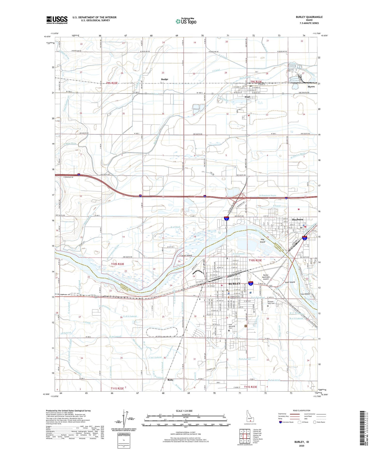
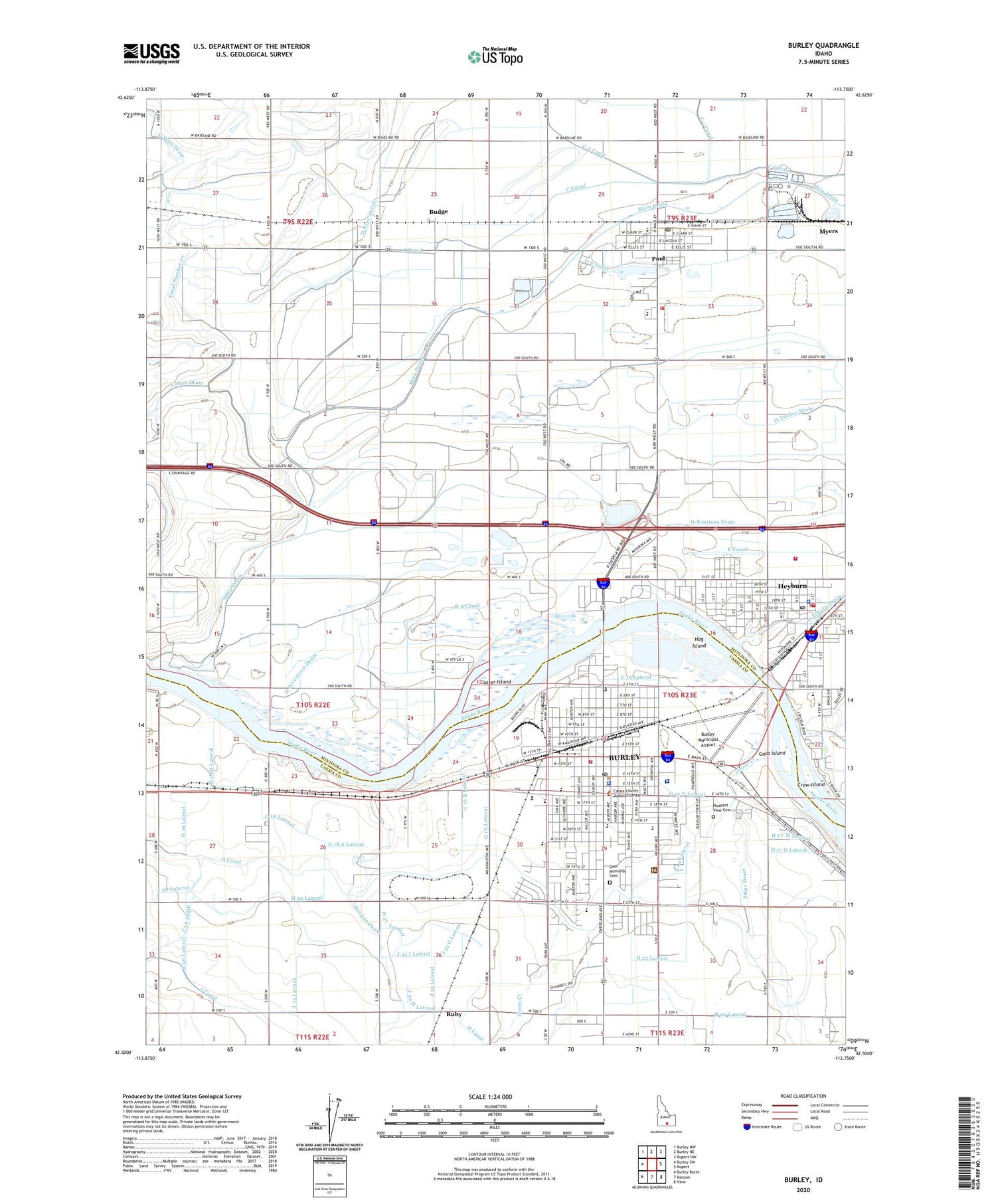
2023 topographic map quadrangle Burley in the state of Idaho. Scale: 1:24000. Based on the newly updated USGS 7.5' US Topo map series, this map is in the following counties: Minidoka, Cassia. The map contains contour data, water features, and other items you are used to seeing on USGS maps, but also has updated roads and other features. This is the next generation of topographic maps. Printed on high-quality waterproof paper with UV fade-resistant inks.
Quads adjacent to this one:
West: Burley SW
Northwest: Burley NW
North: Burley NE
Northeast: Rupert NW
East: Rupert
Southeast: View
South: Kenyon
Southwest: Burley Butte
This map covers the same area as the classic USGS quad with code o42113e7.
Contains the following named places: B-4 Canal, Budge, Bureau of Land Management Burley Field Office, Burley, Burley Fire Department, Burley Junior High School, Burley Municipal Airport, Burley Post Office, Burley Senior High School, Canal Number 20, Cassia County Sheriff's Office, Cassia Regional Medical Center, City of Burley, City of Heyburn, City of Paul, Crow Island, Custer Island, D-Fourteen Drain, D-Nine Drain, D-q Drain, D-Seventeen Drain, D-Twelve Drain, Dworshak Elementary School, East Park, Freedom Park, G 12 1/2 Lateral, G 12 1/2 Pipeline, G 14 Lateral, G 15 A Pipeline, G 15 B Lateral, G 15 B Pipeline, G 15 D Lateral, G 15 Lateral, G 15 Overland Pipeline, G 15 Pipeline, G 152 Lateral, G 16 B Lateral, G 16 Lateral, G 17 Lateral, G 18 A Lateral, G 18 D Lateral, G 18 Lateral, G 19 B Lateral, G 19 Lateral, Gem Memorial Cemetery, Goat Island, Goose Creek, H 17 E Lateral, H 17 E Pipeline, H 17 G Lateral, H 17 H Lateral, H 17 M Lateral, H 17 Rail Road Pipeline, H 17 Spill Pipeline, H 20 Lateral, H 22 A Lateral, H 22 B Lateral, H 22 B Pipeline, H 22 Lateral, H 23 Lateral, H 24 Pipeline, H 25 Pipeline, H 26 H Lateral, H 27 Lateral, H 29 Lateral, H 30 Lateral, H Waste, Heyburn, Heyburn Division, Heyburn Police Department, Heyburn Post Office, Heyburn Seventh-Day Adventist School, Hog Island, Hogan Well, J 27 F Pipeline, J 27 F Waste, J 27 F Waste Pipeline, J 27 M Lateral, J 32 G Lateral, J 32 H Lateral, J 32 I Lateral, J 35 Lateral, J 36 Drain, J 36 Lateral, J 37 Pipeline, J 38 Lateral, KBAR-AM (Burley), Main Drain, Miller School, Minico Alternative High School, Minidoka County Fire Protection District, Mountain View Elementary School, Myers, Overland Elementary School, Paul, Paul Post Office, Pleasant View Cemetery, Ruby, Snake River Plaza, Snipe Gulch Drain, Southwest Elementary School, Starrhs Ferry, West End Fire Protection District, West Minico Middle School, West Park, ZIP Code: 83336