
MyTopo
Acton Indiana US Topo Map
Couldn't load pickup availability
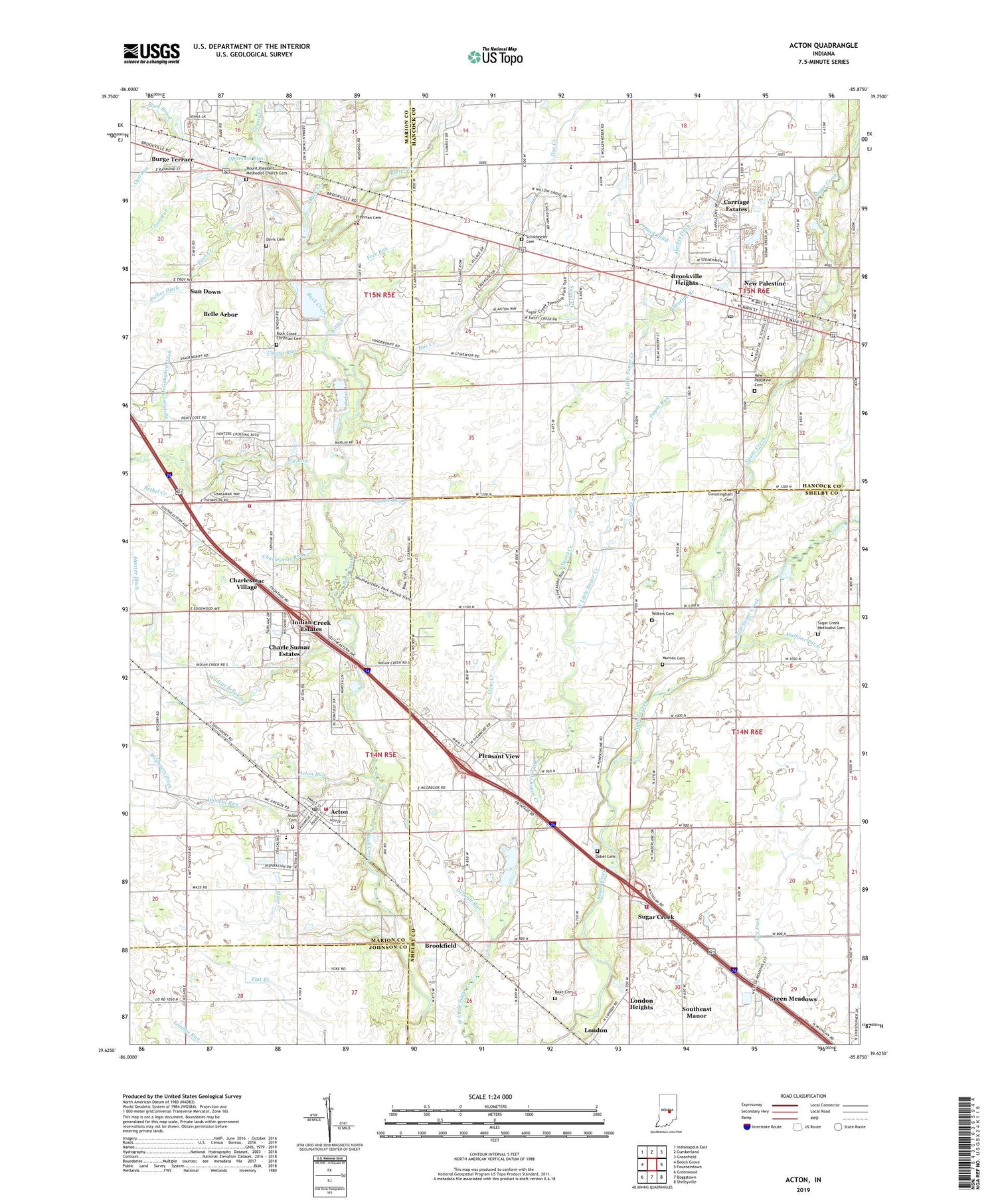
2019 topographic map quadrangle Acton in the state of Indiana. Scale: 1:24000. Based on the newly updated USGS 7.5' US Topo map series, this map is in the following counties: Shelby, Marion, Hancock, Johnson. The map contains contour data, water features, and other items you are used to seeing on USGS maps, but also has updated roads and other features. This is the next generation of topographic maps. Printed on high-quality waterproof paper with UV fade-resistant inks.
Quads adjacent to this one:
West: Beech Grove
Northwest: Indianapolis East
North: Cumberland
Northeast: Greenfield
East: Fountaintown
Southeast: Shelbyville
South: Boggstown
Southwest: Greenwood
Contains the following named places: Acton, Acton Baptist Church, Acton Cemetery, Acton Elementary School, Acton Post Office, Acton Run, Belle Arbor, Bethel Creek, Big Run, Breier Creek, Brookfield, Brookville Heights, Buck Creek Christian Cemetery, Buck Creek Independent Christian Chapel, Burge Terrace, Camp Sertoma, Carriage Estates, Chapel Run, Charle Sumac Estates, Charlesmac Run, Charlesmac Village, Community Christian Church, Coon Run, Cummingham Cemetery, Dake Cemetery, Davis Cemetery, Devault Run, Dobel Cemetery, Doe Creek, Ferris Ditch, Free Run, Freeman Cemetery, Grassy Creek, Green Meadows, Hack Ditch, Hickory Creek, Hunter Ditch, Indian Creek Estates, Indianapolis Fire Department Station 52, Indianapolis Fire Department Station 55, Julietta, Kitty Creek, Lamb Creek, Links Golf Club, Little Run, Little Sugar Creek, London, London Heights, Marshall Field, Maze Creek, Merlau Ditch, Miller Ditch, Moral Township Volunteer Fire Department, Mount Calvary Baptist Church, Mount Pleasant Methodist Church Cemetery, Muesing Creek, Mulliner Ditch, Murnan Cemetery, New Bethel Baptist Church, New Palestine, New Palestine Cemetery, New Palestine Elementary School, New Palestine High School, New Palestine Post Office, New Palestine United Methodist Church, Opo Run, Opossum Run, Palestine Branch, Pleasant View, Poss Branch, Schildmeier Cemetery, Schildmeier Park, Small Branch, Southeast Manor, Southeastway Park, Springer McGaughey Ditch, Stop Branch, Sugar Creek, Sugar Creek Church, Sugar Creek Methodist Cemetery, Sugar Creek Township Fire Department, Sugar Creek Township Fire Department Station 45, Sugar Run, Sum Brook, Sun Down, Sweet Creek, Town of New Palestine, Township of Moral, Township of Sugar Creek, United Faith Baptist Church, View Creek, Whispering Hills Golf Course, Wildcat Brook, Wildcat Run, Wilkins Cemetery, Zion Creek, Zion Lutheran Church, Zion Lutheran School, ZIP Codes: 46163, 46239, 46259


