MyTopo
Greenfield Indiana US Topo Map
Couldn't load pickup availability
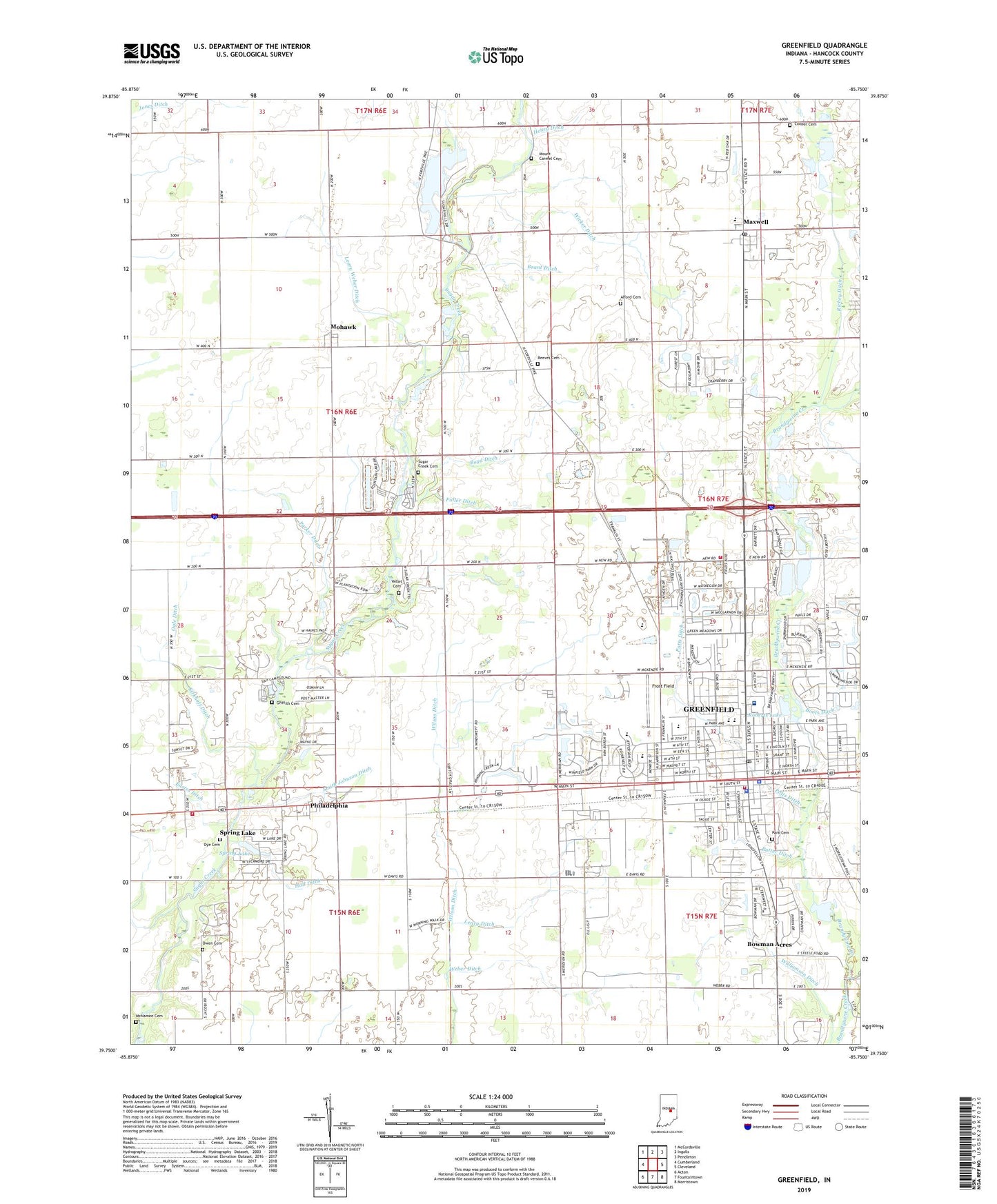
2022 topographic map quadrangle Greenfield in the state of Indiana. Scale: 1:24000. Based on the newly updated USGS 7.5' US Topo map series, this map is in the following counties: Hancock. The map contains contour data, water features, and other items you are used to seeing on USGS maps, but also has updated roads and other features. This is the next generation of topographic maps. Printed on high-quality waterproof paper with UV fade-resistant inks.
Quads adjacent to this one:
West: Cumberland
Northwest: McCordsville
North: Ingalls
Northeast: Pendleton
East: Cleveland
Southeast: Morristown
South: Fountaintown
Southwest: Acton
This map covers the same area as the classic USGS quad with code o39085g7.
Contains the following named places: Alford Cemetery, Boots Ditch, Bowman Acres, Boyd Ditch, Bradley United Methodist Church, Brant Ditch, Church of God, City of Greenfield, Cooper Cemetery, Cooper Corner, Crestview Conservation Club, Dye Cemetery, Eastes Ditch, Faith United Methodist Church, First Baptist Church, First Christian Church, First Presbyterian Church, Frost Field, Fuller Ditch, Grace Baptist Church, Greenfield, Greenfield Conservation Club, Greenfield Courthouse Square Historic District, Greenfield Fire Department Station 421, Greenfield Fire Department Station 422, Greenfield Friends Church, Greenfield High School, Greenfield Police Department, Greenfield Post Office, Greenfield-Central High School, Griffith Cemetery, Hall Ditch, Hancock County, Hancock County Sheriff's Office, Hancock Regional Hospital, Harris Elementary School, Henry Ditch, Immanuel Holiness Church, Jones Ditch, Kirkhoff Ditch, Leary Ditch, Leary Weber Ditch, Life Ambulance, Lincoln Park Elementary School, Little Brandywine Creek, Maxwell, Maxwell Middle School, Maxwell Post Office, Maxwell United Methodist Church, McNamee Cemetery, Memorial Hospital, Mohawk, Mohawk United Methodist Church, Mount Carmel Cemetery, Nazarene Church, New Ditch, Ogle Ditch, Otterbein United Methodist Church, Owen Cemetery, Park Cemetery, Parker Ditch, Philadelphia, Philadelphia United Methodist Church, Potts Ditch, Protestant Church of Greenfield, Putter Ditch, Reeves Cemetery, Richey Ditch, Riley Memorial Park, Riley School, Roberts Lake, Saint Michael School, Saint Michaels Church, Smith Johnson Ditch, Spring Lake, Sugar Creek Cemetery, Sugar Creek Township Fire Department, Sugar Hills, Sugar Hills Lake Dam, Town of Spring Lake, Township of Center, Trinity Park United Methodist Church, Weber Ditch, Weston School, Wicker Ditch, Willet Cemetery, Williamson Ditch, ZIP Code: 46140