MyTopo
Indianapolis East Indiana US Topo Map
Couldn't load pickup availability
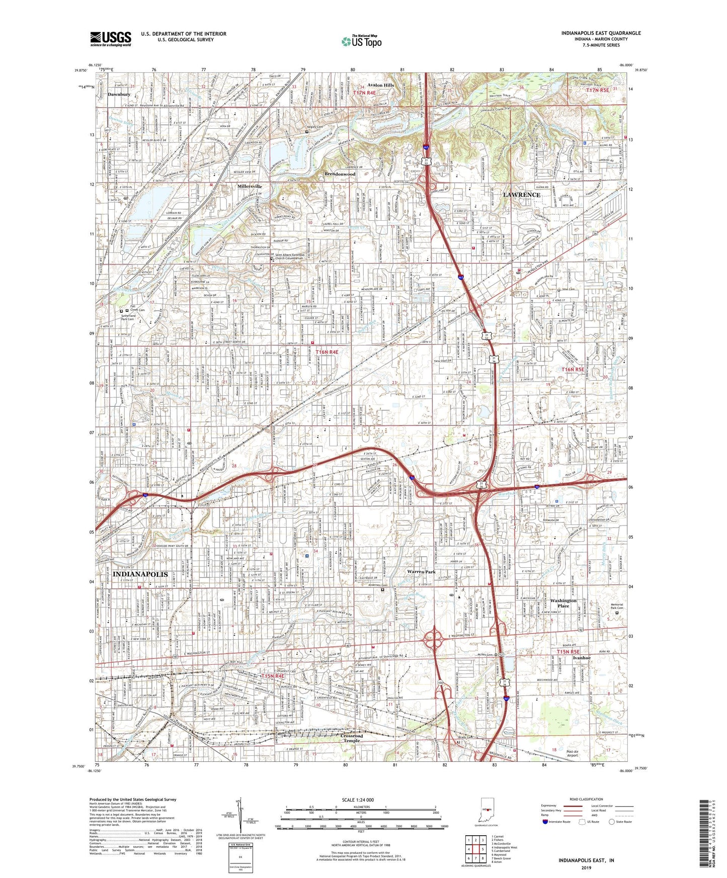
2022 topographic map quadrangle Indianapolis East in the state of Indiana. Scale: 1:24000. Based on the newly updated USGS 7.5' US Topo map series, this map is in the following counties: Marion. The map contains contour data, water features, and other items you are used to seeing on USGS maps, but also has updated roads and other features. This is the next generation of topographic maps. Printed on high-quality waterproof paper with UV fade-resistant inks.
Quads adjacent to this one:
West: Indianapolis West
Northwest: Carmel
North: Fishers
Northeast: McCordsville
East: Cumberland
Southeast: Acton
South: Beech Grove
Southwest: Maywood
This map covers the same area as the classic USGS quad with code o39086g1.
Contains the following named places: Anderson Cemetery, Anna Brochhausen Elementary School, Arlington Heights Elementary School, Arlington High School, Arthington Branch, Atkinson Creek, Ayr-Way Northeast Shopping Center, Bacon Post Office, Beckwith Park, Belzer Middle School, Benton House, Berkshire Creek, Blue Creek, Booth Tarkington Elementary School, Brady Cemetery, Brendonwood, Brien Park, Brightwood, Brightwood Branch Indianapolis-Marion County Public Library, Brightwood Post Office, Brook Park Elementary School, Brookside Creek, Brookside Elementary School, Brookside Industrial Center, Brookside Park, Brookville Business Park, Browning School Number 73, Calvin N Kendall Elementary School, Camp Creek, Central High School, Charles W Fairbanks Elementary School, Christian Park, Christian Park Elementary School, Clayton And LaSalle Park, Clifford Park, Community Hospital East, County Juvenile Center, Crossroad Temple, Dawnbury, Dawson Ditch, Devington Shopping Center, Devon Creek, Doris Cowherd Park, Dubarry Park, East Brightwood, East Washington Branch Indianapolis-Marion County Public Library, East Washington Plaza Shopping Center, Eastgate Post Office, Eastgate Shopping Center, Eastwood Junior High School, Edgar H Evans Elementary School, Ellenberger Park, Emerson Branch Indianapolis-Marion County Public Library, Esquire Plaza, Explorer Park, Fall Creek Elementary School, Fall Creek Union Cemetery, Fatima Retreat House, Fisher Branch, Florence Fay Elementary School, Floro Torrence Elementary School, Forest Manor Park, Fort Benjamin Harrison State Park and Nature Preserve, Fort Branch, Francis Bellamy Elementary School, Francis Scott Key Elementary School, Franklin Road Business Center, Franklin Road Industrial Park, Garden Run, Gardner Park, George B Loomis Elementary School, George Buck Junior High School, George H Fisher Elementary School, George W Julian Elementary School, George Washington Park, Glendale Branch Indianapolis-Marion County Public Library, Glendale Shopping Center, Greene Park, Hamilton School Number 77, Harrison Community Park, Harrison Hill Elementary School, Harrison Place, Hartman Ditch, Hawthorne School Number 50, Hawthorne Yards, Hazel Hart Hendricks Elementary School, Hillcrest Country Club, Hillcrest Creek, Holy Spirit School, Hooks Airport, Hughes Community Center, Hunter Creek Business Park, Indianapolis Fire Department Station 10, Indianapolis Fire Department Station 12, Indianapolis Fire Department Station 15, Indianapolis Fire Department Station 20, Indianapolis Fire Department Station 24, Indianapolis Fire Department Station 25, Indianapolis Fire Department Station 27, Indianapolis Fire Department Station 34, Indianapolis Fire Department Station 42, Indianapolis Fire Department Station 43, Indianapolis Fire Department Station 44, Indianapolis Fire Department Station 8, Indianapolis Water Works Edmundson Station, Irvington, Irvington Branch Indianapolis-Marion County Public Library, Irvington Plaza, Ivanhoe, Jackson Industrial Park, John Strange Elementary School, Joyce Kilmer Elementary School, Juvenile Justice Center, Kenneth Walker Elementary School, Kitley Industrial Park, Ladywood School, Laurel Run, Lawrence, Lawrence Community Park, Lawrence Creek, Lawrence Fire Department Station 38, Lawrence Fire Department Station 39, Lawrence Fire Department Station 40, Lawrence Post Office, Lilly School Number 53, Linwood Post Office, Linwood Square Shopping Center, Lowell School Number 51, Lutherwood Childrens Home, Major General Emmett J Bean Center, Major General Ronald E Brooks Lawrence Government Center, Mallot Park, Martindale Brightwood Health Center, McVey Cemetery, Meadows Brook, Meadows Shopping Center, Memorial Park Cemetery, Menards Shopping Center, Merle Sidener Junior High School, Middle Branch Pleasant Run, Millersville, Minnie Creek, Missions Building, Moon Creek, Moorhead Elementary School, Morris Settles Lawrence Public Safety Building, Mott School Number 3, Mud Creek, Negley Cemetery, North Branch Pleasant Run, North Eastwood Shopping Center, Northwood, Oren Alexander Memorial Park, Oscar Charleston Park, Our Lady of Lourdes School, Park Creek, Parkview Elementary School, Pendleton Pike Shoppes Shopping Center, Pistol Run, Pleasant Run Elementary School, Pleasant Run Golf Club, Post Plaza Shopping Center, Post Road Commerce Park, Post/33rd Business Park, Post-Air Airport, Ralph Waldo Emerson Elementary School, Robert E Sterrett Senior Center, Robert Lee Frost Elementary School, Robinson, Roselawn Park, Saint Albans Episcopal Church Columbarium, Saint Andrew the Apostle School, Saint Bernadette School, Saint Lawrence School, Saint Matthew School, Saint Phillip Neri School, Saint Simon the Apostle School, Saint Therese School, Scecina Memorial High School, Schoen Creek, Scout Branch, Shadeland Community Center, Shadeland Community Center West, Shadeland Industrial Park, Shadeland Plaza Shopping Center, Sherman Commons Shopping Center, Sixthousandthreehundred Business Park, South Branch Pleasant Run, South Creek, Spring Brook, Stoney Creek, Sunnyheights Elementary School, Susan Roll Leach Elementary School, Sutherland Park Cemetery, Sylvian Branch, T C Steele Junior High School, The Fort Golf Course, Thomas Carr Howe High School, Thomas D Gregg Elementary School, Town of Warren Park, Township of Warren, Trinity Lutheran School, Twentythird Street Industrial Park, Twin-Aire Shopping Center, Vine Cemetery, Warren Central High School, Warren Creek, Warren Park, Warren Township Government Center, Washington Place, Washington Street Shopping Center, WBRI-AM (Indianapolis), Weir School Number 71, Wes Montgomery Park, Western Select Industrial Park, WFMS-FM (Indianapolis), WIKS-FM (Greenfield), Willow Brook, Windridge Shopping Center, Windsor Branch, Windsor Village Park, Wishard Emergency Medical Services Medic 010, Wishard Emergency Medical Services Medic 20, WISH-TV (Indianapolis), WNAP-FM (Indianapolis), WNDE-AM (Indianapolis), Woodview Junior High School, Woollen Run, WTLC-FM (Indianapolis), ZIP Codes: 46201, 46216, 46218, 46219, 46220, 46226