MyTopo
Adams Kentucky US Topo Map
Couldn't load pickup availability
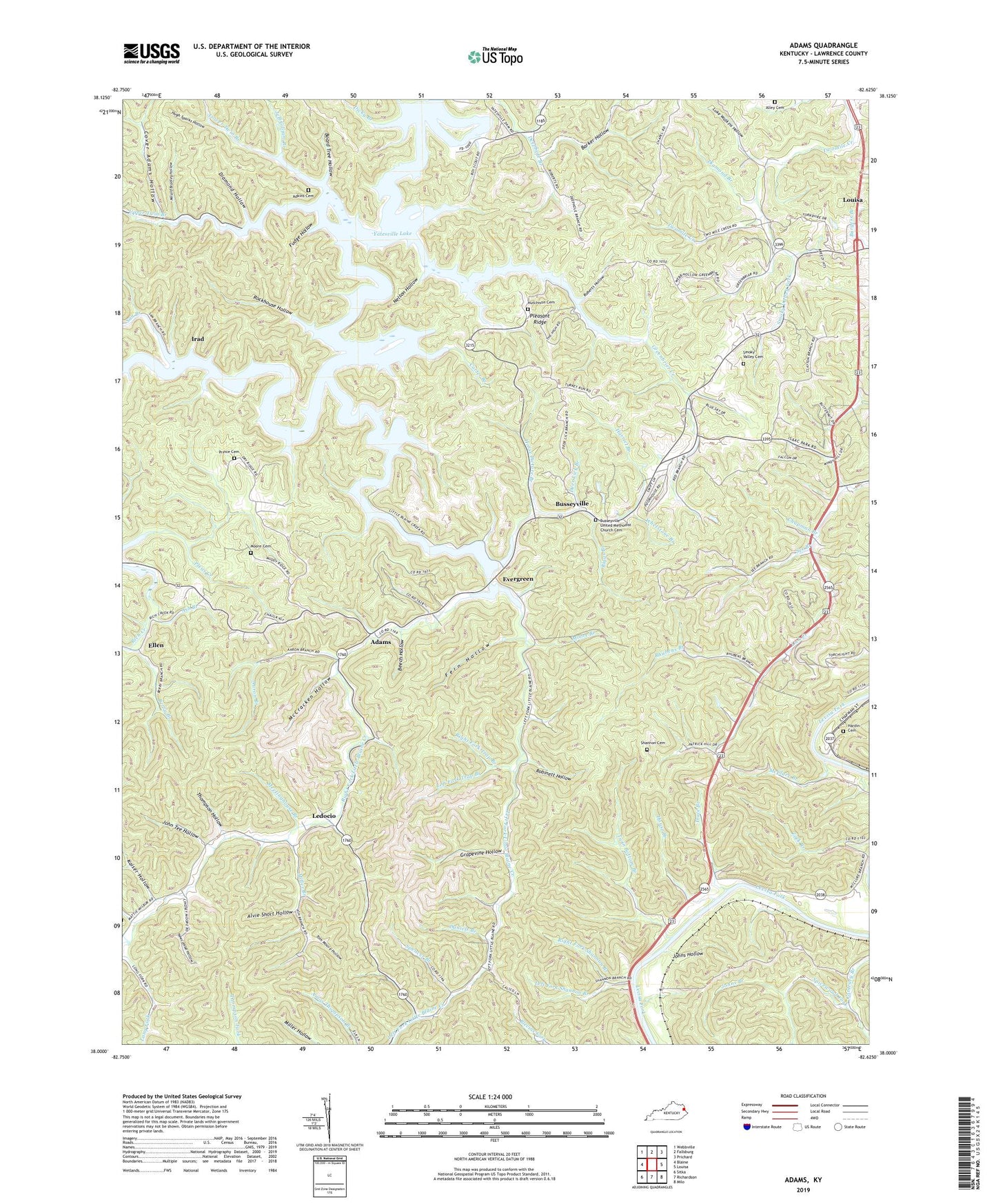
2022 topographic map quadrangle Adams in the state of Kentucky. Scale: 1:24000. Based on the newly updated USGS 7.5' US Topo map series, this map is in the following counties: Lawrence. The map contains contour data, water features, and other items you are used to seeing on USGS maps, but also has updated roads and other features. This is the next generation of topographic maps. Printed on high-quality waterproof paper with UV fade-resistant inks.
Quads adjacent to this one:
West: Blaine
Northwest: Webbville
North: Fallsburg
Northeast: Prichard
East: Louisa
Southeast: Milo
South: Richardson
Southwest: Sitka
This map covers the same area as the classic USGS quad with code o38082a6.
Contains the following named places: Aaron Branch, Adams, Adams Post Office, Adams School, Adkins Cemetery, Alley Cemetery, Alvie Short Hollow, Ash Branch, Barker Boat Ramp, Barker Hollow, Beech Farm, Beech Hollow, Berry Branch, Biggs Branch, Blackburn School, Board Tree Hollow, Busseyville, Busseyville Post Office, Busseyville School, Busseyville United Methodist Church, Busseyville United Methodist Church Cemetery, Carter Branch, Carter Covered Bridge, Carters Chapel, Chapman Branch, Cover Adams Hollow, Daniels Branch, Deephole, Deer Lick Branch, Diamond Branch, Diamond Hollow, Dicky Branch, Dry Ridge Church, Dry Ridge School, Ellen, Ellen Post Office, Evergreen, Evergreen Methodist Church, Evergreen School, Fern Hollow, Fudge Hollow, Grapevine Hollow, Greenbrier Creek, Hardin Cemetery, Harriet Branch, Horse Picture Branch, House Branch, Hugh Sparks Hollow, Hutchison Cemetery, Irad, Irad Post Office, Ivory Post Office, Jeff Gilliam Branch, John Tee Hollow, Johns Branch, Johns Hollow, Jordans Mill, Kaiser Hollow, Lawrence County, Ledocio, Ledocio Post Office, Ledocio Public Bee Hive School, Left Fork Little Blaine Creek, Left Fork Shannon Branch, Left Fork Trap Branch, Little Blaine Creek, Long Branch, Lower Twin Branch, Lower Twin Branch School, Luke Watkins Hollow, Mattie Church, McClure Branch, McCracken Hollow, Meetinghouse Branch, Midway Church, Milard Bradley Hollow, Miller Branch, Moore Branch, Moore Cemetery, Moores Chapel, Nelson Hollow, Newcombe Hollow, Noris Church, Pleasant Ridge, Pleasant Ridge Recreational Area, Pleasant Ridge School, Prince Cemetery, Prince's Mill, Rhubens Branch, Right Fork Little Blaine Creek, Right Fork Shannon Branch, Right Fork Trap Branch, Roberts Hollow, Robinett Hollow, Rockhouse Hollow, San Branch, See Branch, Shannon Branch, Shannon Cemetery, Smoky Valley Cemetery, Smoky Valley Church, Smoky Valley Fork, Spencer Branch, Spicewood Fork, Thompson Hollow, Tom Moore Hollow, Trace Branch, Trap Branch, Twin Bottom Branch, Upper Twin Branch, Webbs Mill, Whetstone Branch, WSAC-FM (Louisa), Yatesville Lake, Yatesville Lake State Park, Yatesville Memorial Gardens, ZIP Codes: 41201, 41230