MyTopo
Louisa Kentucky US Topo Map
Couldn't load pickup availability
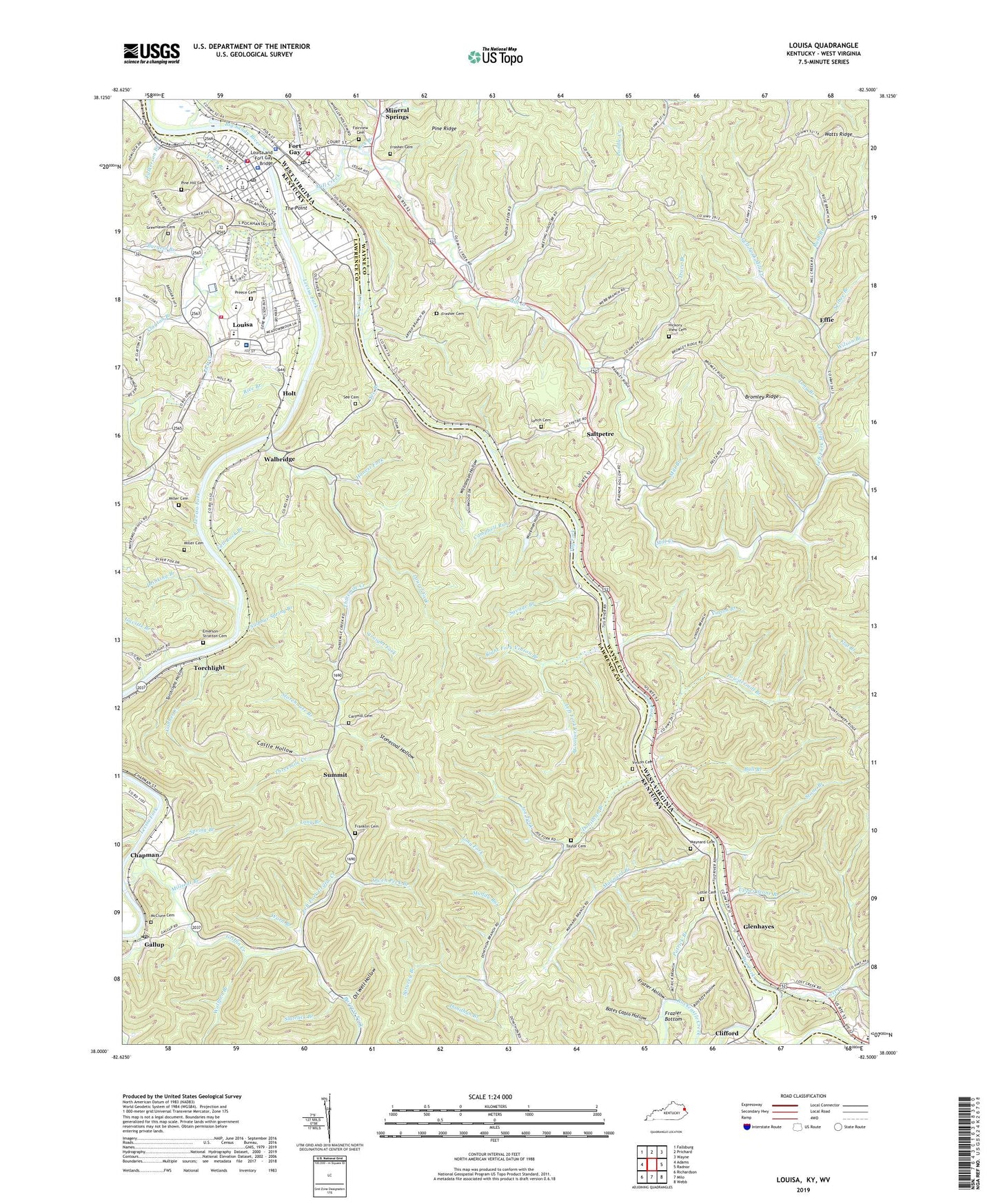
2022 topographic map quadrangle Louisa in the states of Kentucky, West Virginia. Scale: 1:24000. Based on the newly updated USGS 7.5' US Topo map series, this map is in the following counties: Lawrence, Wayne. The map contains contour data, water features, and other items you are used to seeing on USGS maps, but also has updated roads and other features. This is the next generation of topographic maps. Printed on high-quality waterproof paper with UV fade-resistant inks.
Quads adjacent to this one:
West: Adams
Northwest: Fallsburg
North: Prichard
Northeast: Wayne
East: Radnor
Southeast: Webb
South: Milo
Southwest: Richardson
Contains the following named places: Bartram Chapel, Bates Cabin Hollow, Bromley Ridge, Bull Branch, Burgess Branch, Burgess Fork, Campbell Run, Cartmill Cemetery, Castle Hollow, Chapman, Chapman Railroad Station, City of Louisa, Clayton Branch, Clifford, Clifford Post Office, Clifford School, Contrary Branch, Cynthia Chapel, Donathon, Donathon Church, Donathon Post Office, Donathon School, Donithan Branch, Drinking Branch, Effie, Elizabeth Church, Elizabeth Jarrell Church, Eloise Railroad Station, Elouise United Baptist Church, Emerson - Stratton Cemetery, Fairview Cemetery, Fall Rock Branch, Falls of Tug, Field Branch, Fort Gay, Fort Gay Elementary School, Fort Gay PK - 8 School, Fort Gay Police Department, Fort Gay Post Office, Fort Gay Public Library, Fort Gay Volunteer Fire Department, Franklin Cemetery, Frasher Cemetery, Frazier Bottom, Frazier Hollow, Fulkerson Branch, Gallop Railroad Station, Gallop School, Gallup, Gallup Post Office, Gallup-Chapman United Methodist Church, Gavitts Branch, Glenhayes, Gobber Creek, Greenlawn Cemetery, Griffin Creek, Hickory View Cemetery, Holt, Honest Fork, Joe Fork, Laurel Fork, Lawrence County Sheriff's Office, Left Fork Griffin Creek, Left Fork Mill Creek, Left Fork Vinson Branch, Levisa Fork, Lick Branch, Lick Creek, Little Cemetery, Lock and Dam 3, Long Branch, Long Fork, Lost Creek, Louisa, Louisa and Fort Gay Bridge, Louisa Fire Department Station 2, Louisa Fire Station 1, Louisa Police Department, Louisa Post Office, Lower Lick Creek School, Lower Right Fork, Lynch Cemetery, Maynard Branch, Maynard Cemetery, Maynard Post Office, McClure Cemetery, Mill Branch, Mill Creek, Miller Cemetery, Millseat Branch, Mineral Springs, Muddy Run, Northrup Church, Oak Grove Church, Oil Well Hollow, Old Pleasant Church, Owen Peck Branch, Paddle Creek, Patrick Branch, Pecks Railroad Station, Peters Chapel, Pine Hill Cemetery, Pine Ridge, Powdermill Branch, Pratt Branch, Preece Cemetery, Ratcliffe Hollow, Rice Branch, Right Fork Mill Creek, Right Fork Vinson Branch, Rockcastle Creek, Rush Branch, Rush Branch Church, Saltpetre, Savage Branch, See Branch, See Cemetery, See Chapel, Selbee Branch, Slatelick Branch, Smoky Valley, Spring Branch, Sprucey Branch, Stone Branch, Stonecoal Hollow, Storehouse Branch, Straight Fork, Sulphur Spring Branch, Summit, Summit Church, Summit Railroad Station, Summit School, Taylor Cemetery, The Point, Thompson School, Three Rivers Medical Center, Threemile Creek, Tolsia High School, Torchlight, Torchlight Hollow, Tourch Light School, Town Branch, Town of Fort Gay, Trace Branch, Tug Fork, Upper Stone Branch, US Lock Number 1 on the Levisa Fork, US Lock Number 1 Tug River, Vinson Branch, Vinson Cemetery, Vinson Post Office, Walbridge, Walbridge Post Office, Walbridge School, Ward Branch, Williamson Hollow, Wilson Branch, Wilson Chapel, Wolfpen Branch, Workman Hollow, WVKY-AM (Louisa), Zock Branch, ZIP Code: 25514