MyTopo
Grayson Kentucky US Topo Map
Couldn't load pickup availability
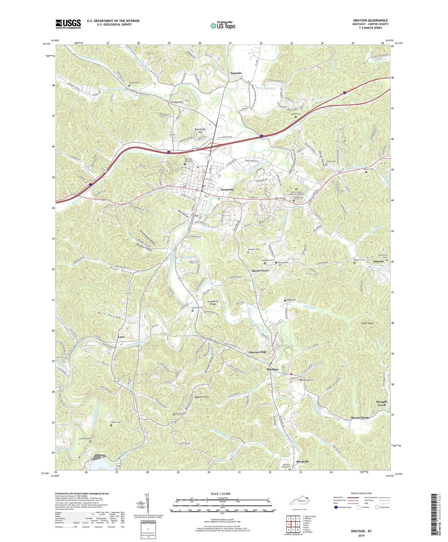
2022 topographic map quadrangle Grayson in the state of Kentucky. Scale: 1:24000. Based on the newly updated USGS 7.5' US Topo map series, this map is in the following counties: Carter. The map contains contour data, water features, and other items you are used to seeing on USGS maps, but also has updated roads and other features. This is the next generation of topographic maps. Printed on high-quality waterproof paper with UV fade-resistant inks.
Quads adjacent to this one:
West: Grahn
Northwest: Tygarts Valley
North: Oldtown
Northeast: Argillite
East: Rush
Southeast: Webbville
South: Willard
Southwest: Bruin
This map covers the same area as the classic USGS quad with code o38082c8.
Contains the following named places: Bald Eagle Hill, Barrett Creek, Barrett Creek Church, Barretts Creek Ford, Beckwith Branch, Beckwith Branch School, Beech Grove, Big Sinking Creek, Black Branch, Blankenship Cemetery, Boggs Cemetery, Bolding Cemetery, Bourbon Hollow, Buckeye School, Burton Cemetery, Camp Robert C. Webb, Canoe Run, Caraway Cemetery, Carter Cemetery, Carter County Emergency Ambulance Service District, Carter County Sheriff's Office, Carter Hollow, City of Grayson, Cresswell Cemetery, Damron Branch, Damron Cemetery Number 2, Dark Hollow, Davy Run, Davy Run School, East Carter County Memory Gardens, Easterling Branch, Easterling Cemetery, Edison Cemetery, Everman Creek, Fairview Hill, Fall Branch, Four Mile School, Fourmile Creek, Fraley Branch, Goebel Cemetery, Goebel Church, Grayson, Grayson Dam, Grayson Division, Grayson Fire Department, Grayson Memorial Cemetery, Grayson Police Department, Grayson Post Office, Greenbrier Ridge, Gum Branch, Hill Hollow, Hitchins, Hitchins Census Designated Place, Hitchins Post Office, Hitchins Volunteer Fire Department, Hudgins Hill Baptist Church, Huff Run, Huff Run Church, Huff Run School, Hunts Knob, Hurricane Hollow, Johns Branch, Katy Branch, Keffer Cemetery, Kentucky Christian College, Leon, Leon Railroad Station, Lindsey Chapel, Little Fork Bridge, Little Fork Little Sandy River, Little Huff Run, Little Sinking Creek, Little Star School, Locust School, Lower Stinson Creek, Lower Wilson School, Mayhew Flats, Meadows Cemetery, Mount Savage, Mount Savage Furnace, Mount Savage Post Office, Mount Savage Railroad Station, Oak Grove Church, Pactolus, Pactolus Furnace, Pactolus United Methodist Church, Pope Hollow, Pope Hollow School, Pope Railroad Station, Powell Creek, Reedville, Reedville Church, Reedville Post Office, Reedville School, Righthand Fork Everman Creek, Robin Run, Savage Memorial Church, Schoolhouse Hollow, Seaton Cemetery, Seaton Railroad Station, Shell Rock School, Stan Branch, Stevens Lake, Stinson, Stinson Church, Stinson School, Straight Creek, Sunrise Valley Golf and Country Club, Tar Kill Branch, The Cross Roads, Tinsley Hill, Town Branch, Union Church, Upper Stinson Creek, Vincent Cemetery, Walker Cemetery, WGOH-AM (Grayson), WKCC-FM (Grayson), Wolf Creek, Wolf Creek Church, Wolf Creek School, Wolfpen Branch, Womack Graveyard, WUGO-FM (Grayson), ZIP Codes: 41143, 41146