MyTopo
Luling Louisiana US Topo Map
Couldn't load pickup availability
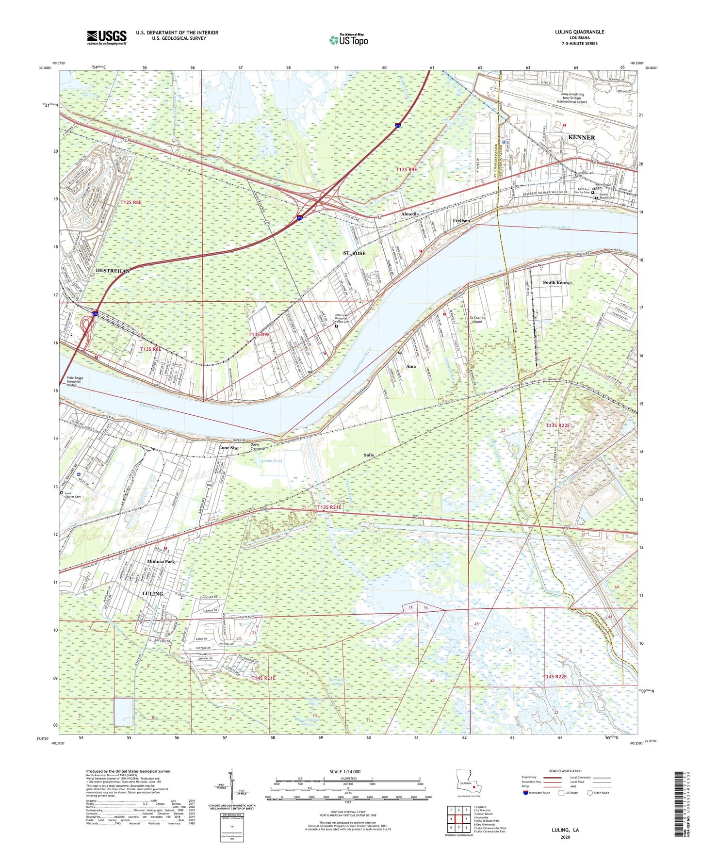
2024 topographic map quadrangle Luling in the state of Louisiana. Scale: 1:24000. Based on the newly updated USGS 7.5' US Topo map series, this map is in the following counties: St. Charles, Jefferson. The map contains contour data, water features, and other items you are used to seeing on USGS maps, but also has updated roads and other features. This is the next generation of topographic maps. Printed on high-quality waterproof paper with UV fade-resistant inks.
Quads adjacent to this one:
West: Hahnville
Northwest: Laplace
North: La Branche
Northeast: Indian Beach
East: New Orleans West
Southeast: Lake Cataouatche East
South: Lake Cataouatche West
Southwest: Des Allemands
This map covers the same area as the classic USGS quad with code o29090h3.
Contains the following named places: A A Songy Sr Kindergarten Center School, Albert Cammon Middle School, Almedia, Ama, Ama Census Designated Place, Ama Park, Ama Post Office, Ama Station, American Cyanamid Company Helistop Heliport, Barton Avenue Church of Christ, Bayou Cypriere Longue, Bayou des Saules, Bell Baptist Church, Bible Center Church, Blessings From Above Daycare Center, Blouin Canal, Boutte Shopping Center, Canal Number Seventeen, Corso, Cousin Canal, Crest Trailer Park, Cross Bayou Canal, Cypress Village Shopping Center, Davis, Davis Crevasse, Davis Plantation, Davis Pond, Destrehan, Destrehan Census Designated Place, Destrehan High School, Destrehan Plantation, Dusuaus Canal, East Bank Head Start Center, East Jefferson Parish Levee District Police Department, East Saint Charles Volunteer Fire Department, Ellington Canal, Fifth African Baptist Church, First Baptist Church, First Union Presbyterian Church, Frellsen, Garland Canal, Grace Kids Day Care Center, Hale Boggs Memorial Bridge, Harry Hurst Middle School, Holy Family Catholic Church, Imtt Field, James Business Park, Jefferson Memorial Gardens Cemetery, Kellogg, Kenner Head Start Center School, King Canal, Lagattuta Park, Lakewood Elementary School, Lanaux Canal, Little Lamb Nursery School, Lone Star, Loquer, Louis Armstrong New Orleans International Airport, Louisa Canal, Luling, Luling Census Designated Place, Luling Elementary School, Luling Living Center, Luling Revetment, Luling United Methodist Church, Luling Volunteer Fire Department, Mimosa Park, Mimosa Park Elementary School, Moisart Heliport, Morgan Park, Morgan Playground, Mount Zion Baptist Church, Mount Zion Church, New Orleans International Airport Fire Station, North Saint Rose Gas Field, Oakland Baptist Church, Ormond Country Club, Outfall Canal, Parish Governing Authority District 2, Parish Governing Authority District 5, Parish Governing Authority District 7, Pecan Grove, Pecan Grove Landing, Pecan Grove School, Peterson Canal, Rehan Wastewater Treatment Plant, Riverbend Business Park, Riverland Mobile Home Park, Rost, Saint Anthony Catholic Church, Saint Charles Borromeo School, Saint Charles Cemetery, Saint Charles Parish, Saint Charles Parish Hospital, Saint Charles Parish Library, Saint Charles Parish Library Saint Rose Branch, Saint Charles Parish Park, Saint Charles Parish Sheriff's Office - Training, Saint Charles Plaza, Saint Charles Specialty Rehabilitation Hospital, Saint Mark Catholic Church, Saint Mary Baptist Church, Saint Rose, Saint Rose Census Designated Place, Saint Rose Elementary School, Saint Rose Landing, Saint Rose Post Office, Saint Rose Volunteer Fire Department District Number 5, Salix, Salvador State Wildlife Management Area, Sauls Canal, Sellers Canal, Sonshine Early Development Center, South Central Professional Development Center, South Kenner, Specialty Rehabilitation Hospital of Luling, St Charles Airport, Stephen J Barbre Middle School, The Church of Jesus Christ of Latter Day Saints, Toddler House II Learning and Development Center, Waggaman Pond, Ward Five, Ward Seven, Ward Two, West Avondale Gas Field, Willowdale Country Club, ZIP Codes: 70031, 70047, 70062, 70087