MyTopo
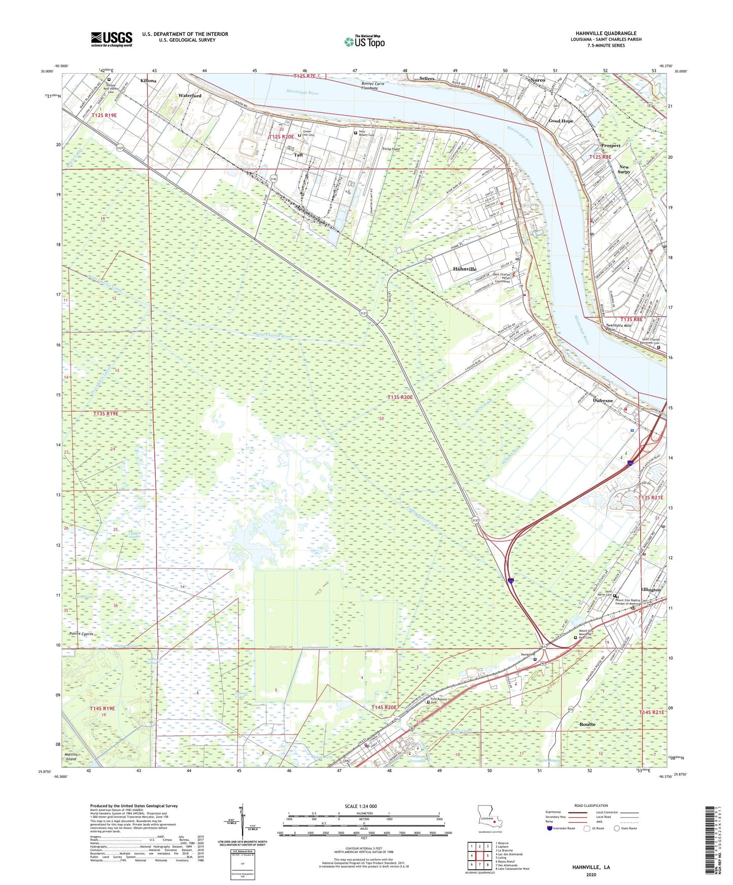
Hahnville Louisiana US Topo Map
Couldn't load pickup availability
2024 topographic map quadrangle Hahnville in the state of Louisiana. Scale: 1:24000. Based on the newly updated USGS 7.5' US Topo map series, this map is in the following counties: St. Charles. The map contains contour data, water features, and other items you are used to seeing on USGS maps, but also has updated roads and other features. This is the next generation of topographic maps. Printed on high-quality waterproof paper with UV fade-resistant inks.
Quads adjacent to this one:
West: Lac des Allemands
Northwest: Reserve
North: Laplace
Northeast: La Branche
East: Luling
Southeast: Lake Cataouatche West
South: Des Allemands
Southwest: Bayou Boeuf
This map covers the same area as the classic USGS quad with code o29090h4.
Contains the following named places: Bird Island, Boutte, Boutte Assembly of God Church, Boutte Census Designated Place, Boutte Christian Academy, Boutte Post Office, Boutte School, Christian Family Fellowship Church, Covenant Church, Cypress Island, Destrehan High School, Destrehan Post Office, Dufresne, E J Landry Sr Alternative School, East Saint Charles Volunteer Fire Department, East Saint Charles Volunteer Fire Department Station 1, Eighty Arpent Canal, Ellington, Ethel Schoeffner Elementary School, Faith Praise and Deliverance Church, Fashion Golf Course, First Baptist Church, Flagville, George Washington Carver Early Learning Center School, Good Hope, Good Hope Landing, Good Hope Missionary Baptist Church, Good Hope Presbyterian Church, Green Hill Cemetery, Hahnville, Hahnville Baptist Church, Hahnville Census Designated Place, Hahnville High School, Hahnville Landing, Hahnville Post Office, Hahnville School, Hahnville Volunteer Fire Department District Number 3, Harvest Time Christian Center, Holy Rosary Cemetery, Holy Rosary Church, Hymel Canal, J B Martin Middle School, Johnson Canal, Johnson Island, Killona Census Designated Place, King Jesus Ministries, Kingdom Hall Church, Lake Des Allemands Oil and Gas Field, Luling Post Office, Martins Island, Marys Canal, Mount Airy Baptist Church, Mount Airy Church, Mount Zion Baptist Church, New Sarpy, New Sarpy Census Designated Place, New Sarpy Elementary School, New Sarpy Kindergarten Center, New Sarpy Post Office, Norco, Norco Census Designated Place, Ormand Landing, Ormond Landing, Ormond Nursing and Care Center, Paradis, Paradis Oil and Gas Field, Paradis Post Office, Parish Governing Authority District 1, Philadelphia Baptist Church, Polete Canal, Prospect, R J Vial Elementary School, R J Vial School, R K Smith Middle School, River of Life Church, Saint Charles Borromeo Cemetery, Saint Charles Church, Saint Charles Parish Library East Regional Branch, Saint Charles Parish Library Hahnville Branch, Saint Charles Parish Park, Saint Charles Parish Police Jury, Saint Charles Parish Satellite Center, Saint Charles Parish Sheriff's Office, Saint Charles Parish Sheriff's Office Communications, Saint Charles United Methodist Church, Saint James United Methodist Church, Saint Marys Cemetery, Saint Matthew Baptist Church, Sellers, Small World Day Care and Learning Center, South Taft Gas Field, Summers Island, Taft, Taft Census Designated Place, Telephone Company Heliport, Triche Field, Tru Vine Baptist Church, Twentysix Mile Point, Vial Canal, Victor Canal, Ville Wastewater Treatment Plant, Ward One, Ward Three, Waterford, Waterford 3 Heliport, Waterford Revetment, West Saint Charles Baptist Church, Young Cemetery, ZIP Codes: 70039, 70057, 70080