MyTopo
Springfield Louisiana US Topo Map
Couldn't load pickup availability
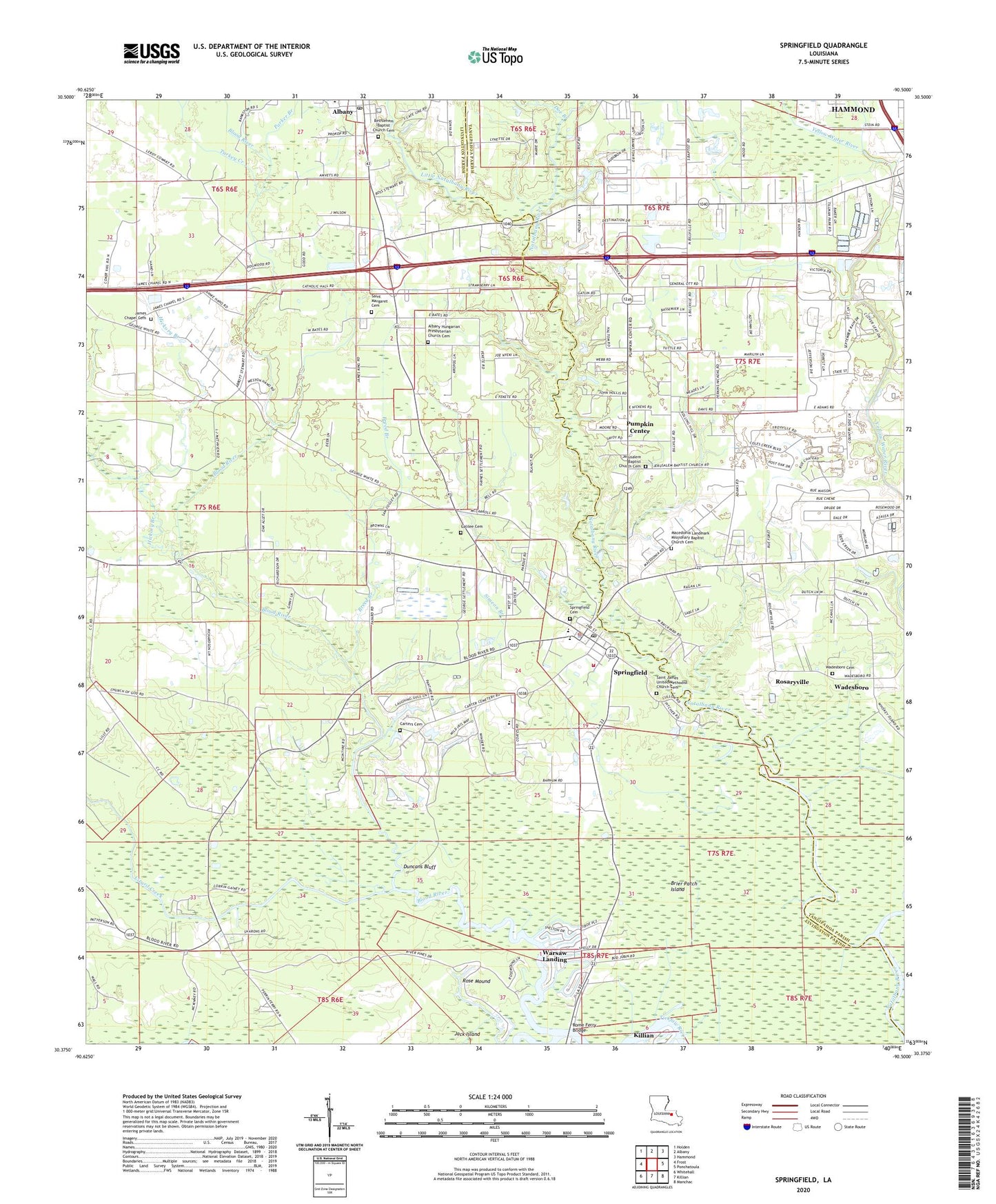
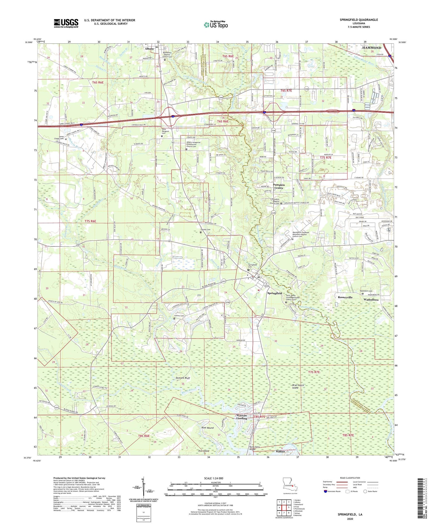
2020 topographic map quadrangle Springfield in the state of Louisiana. Scale: 1:24000. Based on the newly updated USGS 7.5' US Topo map series, this map is in the following counties: Livingston, Tangipahoa. The map contains contour data, water features, and other items you are used to seeing on USGS maps, but also has updated roads and other features. This is the next generation of topographic maps. Printed on high-quality waterproof paper with UV fade-resistant inks.
Quads adjacent to this one:
West: Frost
Northwest: Holden
North: Albany
Northeast: Hammond
East: Ponchatoula
Southeast: Manchac
South: Killian
Southwest: Whitehall
Contains the following named places: Albany High School, Albany Hungarian Presbyterian Church Cemetery, Albany Post Office, Bankstons Mobile Home Park, Bethlehem Baptist Church, Bethlehem Baptist Church Cemetery, Bible Baptist Church, Blockade Landing, Blood River, Blood River Church, Booth Shell Bank, Breed Branch, Brier Patch Island, Butler Bayou, Carter Landing, Carter Plantation, Carter Plantation Golf Course, Carters Cemetery, Cullom Landing, Doe Branch, Duncans Bluff, Faith Gospel Bible Institute, First United Methodist Church of Springfield, Galilee Baptist Church, Galilee Cemetery, Gatlin School, Goodwill Church, Hickory Branch, Holly Church, Hungarian Church, Hungarian School, Hungarian Settlement, Jack Island, James Chapel, James Chapel Cemetery, James Chapel United Methodist Church, Jerusalem Baptist Church, Jim's Mobile Home Park, Landon Mobile Home Park, Little Natalbany River, Lizard Creek, Lobell Farms Dam, Macedonia Church, Mount Olive Baptist Church, Parker Branch, Ponchatoula Creek, Pumpkin Center, Redemption Christian Center, Robinwood, Rome, Rome Ferry Bridge, Romes Ferry, Rosaryville, Rosaryville Spirit Life Center, Rose Mound, Saint James Church, Saint James United Methodist Church Cemetery, Saint Margaret Cemetery, Saint Margarets Church, Simeon Branch, Springfield, Springfield Cemetery, Springfield Elementary School, Springfield Head Start School, Springfield High School, Springfield Middle School, Springfield Police Department, Springfield Post Office, Springfield Volunteer Fire Department, Starnee Church, Tilman Park, Town of Springfield, Trinity Baptist Church, Tucker Landing, Turkey Creek, Vacajun Marina, Village of Albany, Wadesboro Cemetery, Ward Four, Warsaw Landing, Warsaw Marina, Woodland Baptist Church, ZIP Code: 70462