MyTopo
Bath Maine US Topo Map
Couldn't load pickup availability
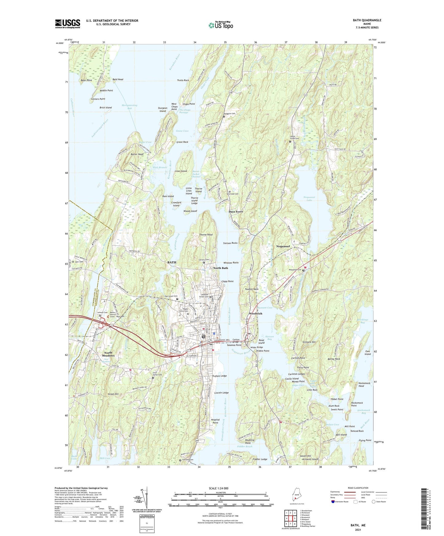
2024 topographic map quadrangle Bath in the state of Maine. Scale: 1:24000. Based on the newly updated USGS 7.5' US Topo map series, this map is in the following counties: Sagadahoc, Cumberland. The map contains contour data, water features, and other items you are used to seeing on USGS maps, but also has updated roads and other features. This is the next generation of topographic maps. Printed on high-quality waterproof paper with UV fade-resistant inks.
Quads adjacent to this one:
West: Brunswick
Northwest: Bowdoinham
North: Richmond
Northeast: Wiscasset
East: Westport
Southeast: Boothbay Harbor
South: Phippsburg
Southwest: Orrs Island
This map covers the same area as the classic USGS quad with code o43069h7.
Contains the following named places: Alum Rock, Arrowsic Island, Arrowsic School, Assembly of God Church, Back River Creek, Bald Head, Barley Neck, Bath, Bath Alliance Church, Bath Center for the Arts, Bath Chamber of Commerce, Bath Country Club, Bath Fire Department, Bath Foursquare Church, Bath Iron Works, Bath Iron Works Fire Department, Bath Middle School, Bath Police Department, Bath Post Office, Bath Regional Technical Center, Bath Regional Vocational Center, Bath Shopping Center, Bath Town Landing, Bean Point, Bowdoinham Wildlife Management Area, Brick Island, Brox Creek, Burnt Jacket Channel, Butler Cove, Butler Head, Calvary Cemetery, Carleton Ledges, Carlton Bridge, Carlton Point, Castle Island, Center Church, Centers Point, Childrens School of Arts and Science, Chocolate Church, Chop Point Camp, Chop Point School, Chops Creek, Chops Crossroads, Chops Point, Church of the Nazarene, City of Bath, Clapp Point, Corliss Street Baptist Church, Crawford Island, Davenport Memorial Building, Davenport Memorial Museum, Days Ferry, Days Ferry Historic District, Dike Newell School, Dike School, Doubling Point, Doubling Point Light Station, Dummer Street Cemetery, Ewe Island, Fairview Cemetery, Ferry Point, Fiddler Ledge, Fiddler Reach, First Apostolic Church, First Baptist Church, First Church of Christ Scientist, First Parish Cemetery, Fisher Mitchell School, Flying Point, Gilmore Hill, Goose Cove, Grace Episcopal Church, Grace Rock, Great Hill, Ham Cemetery, Hanson Bay, Hockomock Head, Hockomock Point, Hodgkins Cemetery, Hospital Point, Huse Memorial School, Hyde School, Kennebec River Light Station, Kennebec School, Laurel Grove Cemetery, Lemont Cemetery, Lime Rock, Lincoln Ledge, Lines Island, Little Lines Island, Littlefield School, Lowell School, Maine Maritime Museum, Maine Maritime Museum Library, Maple Grove Cemetery, Marine Museum, Maritime History Building, Merrymeeting Bay, Middle Point, Mill Island, Mill Point, Money Point, Morse High School, Nequasset, Nequasset Brook, Nequasset Cemetery, Nequasset Lake, Nequasset Lake Dam, Nequsset, New Meadows, North Bath, North Meadows, Oak Grove Cemetery, Palace Cove, Patten Free Library, Peggy Island, Percy and Small Dock, Pleasant Cove, Preble Point, Ram Island, Read Island, Riverside Cemetery, Sagadahoc County, Sagadahoc County Law Library, Sagadahoc County Sheriff's Office, Saint Marys Catholic Church, Sasanoa Point, Sewell Creek, Sewell Hill, Sewell House, Snipe Cove, Stetson Rocks, Sturgeon Island, Swett Point, The Children's Schoolhouse, The Chops Passage, Thorne Head, Thorne Island, Thorne Island Ledge, Tibbet Point, Tomcod Rock, Towesic Neck, Town of West Bath, Town of Woolwich, Trotts Rock, Trufant Ledge, United Church of Christ, United Methodist Church, United States Customs House, Upper Hell Gate, West Bath School, West Bath Volunteer Fire Department, West Branch, West Chops Point, Whiskeag Creek Dam, Whiskeag Pond, Wilder Bridge, Winnegance Causeway Dam, Winnegance Creek, Winnegance Lake, Winslow Rocks, Winter Street Church, Wiskeag Creek, WJTO Radio Tower (Havre De Grace), WJTO-AM (Bath), WMOS-FM (Bath), Woods Island, Woolwich, Woolwich Central School, Woolwich Fire Department, Woolwich Town House, ZIP Codes: 04530, 04579