MyTopo
Boothbay Harbor Maine US Topo Map
Couldn't load pickup availability
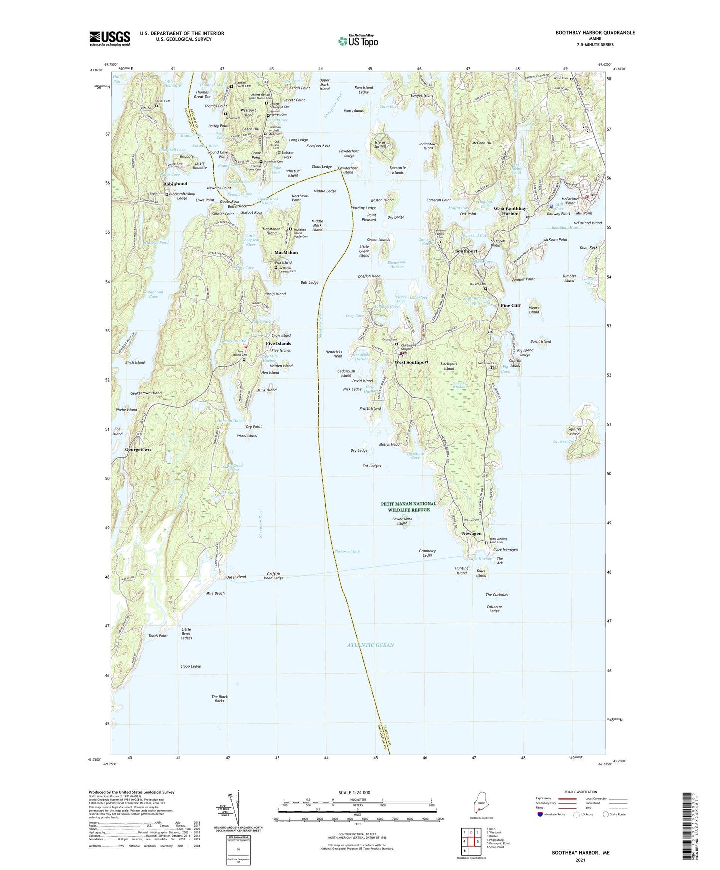
2024 topographic map quadrangle Boothbay Harbor in the state of Maine. Scale: 1:24000. Based on the newly updated USGS 7.5' US Topo map series, this map is in the following counties: Lincoln, Sagadahoc. The map contains contour data, water features, and other items you are used to seeing on USGS maps, but also has updated roads and other features. This is the next generation of topographic maps. Printed on high-quality waterproof paper with UV fade-resistant inks.
Quads adjacent to this one:
West: Phippsburg
Northwest: Bath
North: Westport
Northeast: Bristol
East: Pemaquid Point
Southwest: Small Point
This map covers the same area as the classic USGS quad with code o43069g6.
Contains the following named places: All Saints by the Sea Episcopal Church, Bailey Cove, Bailey Point, Beal Cove, Beals Cemetery, Beech Hill, Bigelow Laboratory and Maine Department of Marine Resources Library, Birch Island, Blacksmithshop Ledge, Blake Cove, Boiler Rock, Boothbay Baptist Church, Boothbay Harbor, Boothbay Harbor Ambulance Service Coast Guard, Boothbay Harbor Memorial Library, Boothbay Harbor Municipal Building, Boothbay Harbor Police Department, Boothbay Harbor Post Office, Boothbay Harbor Region Chamber of Commerce, Boothbay Harbor Volunteer Fire Station, Boothbay Harbor Yacht Club, Boothbay Region Elementary School, Boothbay Region High School, Boothbay Regional Historical Society and Museum, Boston Island, Brook Point, Brooks Cove, Bull Ledge, Burnt Island, Burnt Island Light Station, Cameron Cove, Cameron Point, Camp Sequin, Campbell Cove, Campbell Creek, Cape Harbor, Cape Island, Cape Newagen, Capitol Island, Cat Ledges, Cedarbush Island, Charles Pond, Christmas Cove, Clam Cove, Clam Rock, Clareys Pond, Clous Ledge, Coast Guard Station Boothbay Harbor, Collector Ledge, Cozy Harbor, Cranberry Ledge, Crow Island, Cuckolds Lighthouse, David Island, Deckers Cove, Deep Cove, Dogfish Head, Dry Ledge, Dry Point, Ebenecook Harbor, Factory Cove, First Church of Christ Scientist, Fishermans Wharf, Five Island Cemetery, Five Island Second Baptist Church, Five Islands, Five Mile Harbor, Fog Island, Fourfoot Rock, Fox Island, Georgetown, Georgetown Volunteer Fire Station Five Island, Goose Rock, Goose Rock Passage, Gotts Cove, Gray Homestead Campground, Green Islands, Griffith Head Ledge, Grove Cemetery, Harding Ledge, Harmon Harbor, Harriman Mitchell Stacy Cemetery, Hawks Nest Teen Center, Hen Island, Hendricks Harbor, Hendricks Head, Hendricks Head Light Station, Hendricks Hill Museum, Hogdon Cove, Hunting Island, Ice Pond, Indiantown Island, Indiantown Preserve, Isle of Springs, James Jewett Cemetery, Jewett Cove, Jewett Nelson Blake Moore Cemetery, Jewett Point, Jewett Schweppe Cemetery, Josephine Newman Sanctuary, Juniper Point, Kehail Cemetery, Kehali Point, Knubble, Knubble Bay, Labrador Meadow, Laura E Richards Library, Lions Club, Little Good Harbor, Little Green Island, Little Hell Gate, Little Knubble, Little River, Little River Ledges, Little Sheepscot River, Lobster Rock, Long Cove, Long Ledge, Love Cove, Lowe Point, Lower Mark Island, MacMahan, MacMahan Island, Maddock Cove, Maine Department of Marine Resources Aquarium, Maine Department of Marine Resources Bigelow Laboratory, Malden Island, McCobb Hill, McFarland Island, McFarland Point, McKown Point, McMahan Island Apple Cemetery, McMahan Learned Cemetery, Meadow Shopping Center, Middle Ledge, Middle Mark Island, Mile Beach, Mill Cove, Mill Point, Mill Pond, Mink Island, Moffat Cove, Mollys Head, Mouse Island, Newagen, Newagen Post Office, Newdick Cove, Newdick Point, Nick Ledge, Northeast Point, Oak Point, Old Brooks Cemetery, Outer Head, Phebe Island, Pier 1, Pier 6, Pier 7, Pier 8, Pierce Cove, Pig Cove, Pig Island Ledge, Pine Cliff, Point Pleasant, Powderhorn Island, Powderhorn Ledge, Pratts Island, Railway Point, Ram Island Ledge, Ram Islands, Reid State Park, Riggs Cove, Robinhood, Robinhood Cove, Robinhood Marine Center, Robinson Wharf, Round Cove, Round Cove Point, Saint Andrews Hospital Healthcare Center, Saint Andrews Hospital Medical Library, Sasanoa River, Sawyer Island, Sheepscot Bay, Sheepscot River, Sixfoot Rock, Sloop Ledge, Soldier Point, Southport, Southport Bridge, Southport Central School, Southport Island, Southport Memorial Library, Southport Post Office, Southport Town Hall, Southport Volunteer Main Fire Station, Southport Water Supply Pond, Southport Water Supply Pond Dam, Southport Yacht Club, Spectacle Islands, Spruce Point Chapel, Squirrel Cove, Squirrel Island, Stephen Jewett Cemetery, The Ark, The Black Rocks, The Cuckolds, Thomas Brooks Cemetery, Thomas Cove, Thomas Great Toe, Thomas Point, Todds Point, Town of Boothbay Harbor, Town of Georgetown, Town of Southport, Townsend Gut, Tumbler Island, Turnip Island, Upper Mark Island, Wattons Wharf, West Boothbay Harbor, West Boothbay Harbor Post Office, West Harbor Pond, West Harbor Pond Dam, West Southport, West Southport Post Office, White Cove, Whittum Island, Wilson Cemetery, Wood Island, Wylie Cemetery, YMCA Building, ZIP Codes: 04538, 04548, 04570, 04575, 04576