MyTopo
Gorham Maine US Topo Map
Couldn't load pickup availability
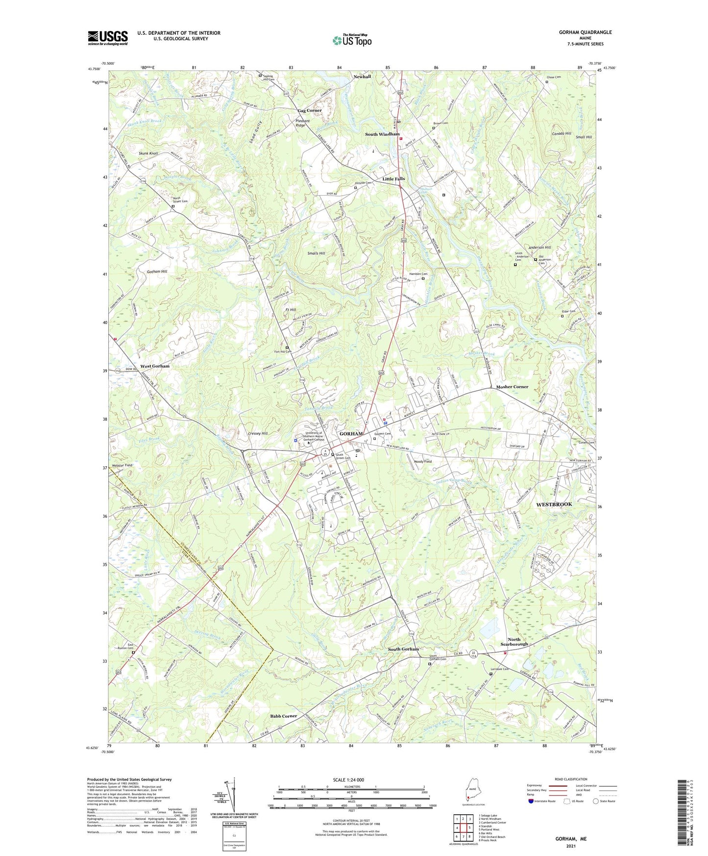
2021 topographic map quadrangle Gorham in the state of Maine. Scale: 1:24000. Based on the newly updated USGS 7.5' US Topo map series, this map is in the following counties: Cumberland, York. The map contains contour data, water features, and other items you are used to seeing on USGS maps, but also has updated roads and other features. This is the next generation of topographic maps. Printed on high-quality waterproof paper with UV fade-resistant inks.
Quads adjacent to this one:
West: Standish
Northwest: Sebago Lake
North: North Windham
Northeast: Cumberland Center
East: Portland West
Southeast: Prouts Neck
South: Old Orchard Beach
Southwest: Bar Mills
Contains the following named places: Anchor Missionary Fellowship Church, Anderson Brook, Anderson Hall, Anderson Hill, Babb Corner, Bailey Hall, Baxter Memorial Library, Black Brook, Brandy Brook, Brooks Student Center, Brown Cemetery, Canada Hill, Charles Shaw Junior High School, Chase Cemetery, Cold Spring Brook, Colley Wright Brook, Community Church, Corthell Hall, Cressey Hill, Deering Brook, Dickey Wood Hall, Douglas Brook, Duck Pond School, East Buxton Cemetery, East Buxton Church, Eastern Cemetery, Elder Cemetery, Elmwood School, Farm Brook, Files Brook, First Parish Congregational Church, Fort Hill, Fort Hill Brook, Fort Hill Cemetery, Gag Corner, Gambo Falls Dam, Gorham, Gorham Campus Historic District, Gorham Campus Library, Gorham Census Designated Place, Gorham Christian Assembly Church, Gorham Country Club, Gorham Fire Department Central Station, Gorham Fire Department West Gorham Station, Gorham High School, Gorham Middle School, Gorham Police Department, Gorham Raceway, Gorham Town Farm, Gorham Town Hall, Gorham Village Plaza Shopping Center, Gotham Hill, Great Falls Elementary School, Gully Brook, Hamblen Brook, Hamblen Cemetery, Highland Cliff Advent Church, Hillside Cemetery, Indian Camp Brook, Inkhorn Brook, John Mitchell Center, Johnson Brook, Land of Nod, Larrabee Cemetery, Lincoln Weeks Brook, Little Falls, Little Falls Baptist Church, Little Falls Census Designated Place, Little Falls Dam, Little Falls School, Little Falls-South Windham Census Designated Place, Little River, Longfellow School, Maine Correctional Center, Maine Forestry Service, Mallison Falls, Mallison Falls Dam, Martin Brook, McLellan House, Milliken Brook, Moody Field, Mosher Brook, Mosher Corner, Narragansett Elementary School, North Branch Little River, North Scarborough, North Street Cemetery, North Street Church, Old Anderson Cemetery, Pleasant Ridge, Presidents House, Robie School, Robie-Andrews Hall, Russell Hall, Saccarappa School, Samborn Brook, Sapling Hill Cemetery, Scarborough Fire Department Station 5 North Scarborough, School Street United Methodist Church, Shad Gully, Skunk Knoll, Skunk Knoll Brook, Small Hill, Smalls Hill, Smith - Anderson Cemetery, South Branch Stroudwater River, South Gorham, South Gorham Baptist Church, South Gorham Cemetery, South Street Cemetery, South Street Historic District, South Windham, South Windham Census Designated Place, South Windham Community Church, South Windham Public Library, State Reformatory for Men, Strout Brook, Tannery Brook, Town of Gorham, University of Southern Maine - Gorham Campus, University of Southern Maine Police Department, Upton-Hastings Hall, Village Elementary School, Ward Brook, Warren Hill Gymnasium, West Gorham, Westbrook City Farm, Westcott Brook, Westerly Winds Golf Course, Whitney School, Windham Fire Rescue Department South Station, Windham Real School, WLVP-FM (Gorham), WMPG-FM (Gorham), Woodward Hall, WRED-AM, ZIP Code: 04038