MyTopo
Portland West Maine US Topo Map
Couldn't load pickup availability
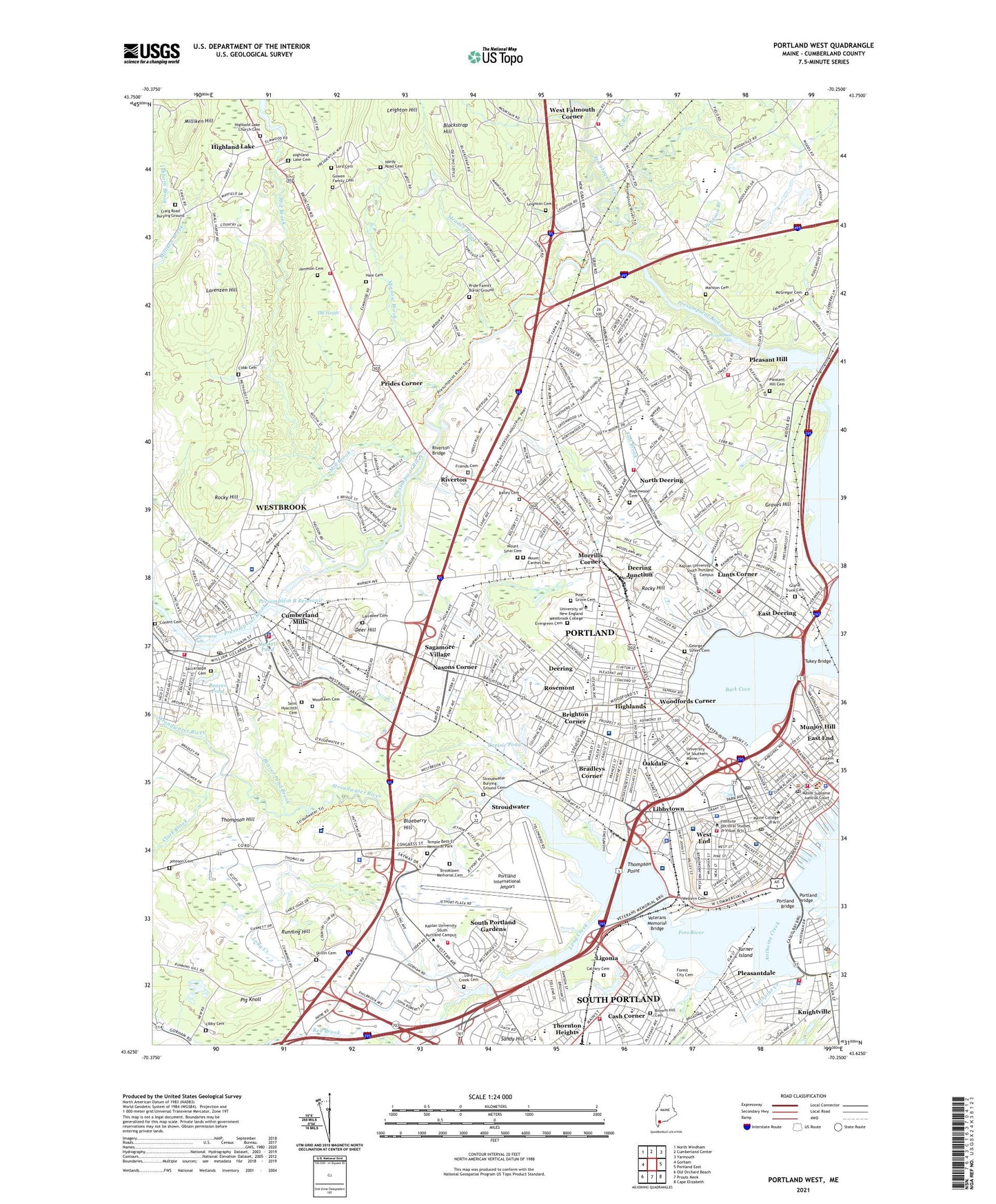
2024 topographic map quadrangle Portland West in the state of Maine. Scale: 1:24000. Based on the newly updated USGS 7.5' US Topo map series, this map is in the following counties: Cumberland. The map contains contour data, water features, and other items you are used to seeing on USGS maps, but also has updated roads and other features. This is the next generation of topographic maps. Printed on high-quality waterproof paper with UV fade-resistant inks.
Quads adjacent to this one:
West: Gorham
Northwest: North Windham
North: Cumberland Center
Northeast: Yarmouth
East: Portland East
Southeast: Cape Elizabeth
South: Prouts Neck
Southwest: Old Orchard Beach
This map covers the same area as the classic USGS quad with code o43070f3.
Contains the following named places: Anthoine Creek, Back Cove, Back Cove Historic District, Back Cove Park, Bailey Cemetery, Barberry Creek, Baxter Pines, Baxter Woods, Beaver Pond, Beaver Pond Brook, Blackstrap Hill, Blueberry Hill, Boothby Square, Bradles Plaza Shopping Center, Bradleys Corner, Bridge Saint School, Bridgton Medical Center, Brighton Corner, Brooklawn Memorial Cemetery, Brown Saint School, Browns Wharf, Butler School, Calvary Cemetery, Capisic Pond, Cash Corner, Chandlers Wharf, Cheverus High School, City of South Portland, City of Westbrook, Clark Brook, Clark Pond, Clark Pond Dam, Cobb Cemetery, Conant Cemetery, Congress Square, Congress Square Park, Cornerbrook Shopping Center, Craig Road Burying Ground, Crocketts Corner, Cumberland Dam, Cumberland Mills, Cumberland Mills Historic District, Cumberland Wharf, Cummings School, Deer Hill, Deering, Deering High School, Deering Junction, Deering Oaks Park, Deering Street Historic District, East Branch Piscataqua River, East Deering, Eastern Cemetery, Edward Payson Park, Evergreen Cemetery, Fall Brook, Falmouth High School, Fore River Sanctuary, Forest Avenue Plaza Shopping Center, Forest City Cemetery, Fort Allen Park, Fort Sumner Park, Friends Cemetery, Garrison Hills Estates, George Street Cemetery, Gowen Family Cemetery, Grand Trunk Cemetery, Graves Hill, Graves School, Greater Portland Christian School, Grubb Hill, Hadlock Field, Hale Cemetery, Hardy Cemetery, Haskell Pond, Henry Wadsworth Longfellow Monument, Highland Lake, Highland Lake Cemetery, Highland Lake Church Cemetery, Highland Lake Dam, Highlands, Hinckley Park, Hobsons Wharf, Huston School, Jack Junior High School, James Otis Kaler Elementary School, Jameson Cemetery, Johnson Branch, Johnson Cemetery, King Middle School, Knightville, Larrabee Cemetery, Leighton Cemetery, Leighton Hill, Libbytown, Ligonia, Lincoln Middle School, Lincoln Park, Lone Creek Village, Long Creek, Long Wharf, Longfellow Elementary School, Longfellow Square, Lorenzen Hill, Lunts Corner, Lyman Moore Middle School, Maine Eye and Ear Infirmary, Maine Medical Center, Mall Plaza Shopping Center, Maplewood Cemetery, Marineast, Marston Cemetery, McGregor Cemetery, Meader Brook, Mercy Hospital Express Care, Mill Brook, Mill Creek Park, Mill Creek Shopping Center, Milliken Hill, Minnow Brook, Monument Square, Monument Square Shopping Center, Morrills Corner, Mount Carmel Cemetery, Mount Sinai Cemetery, Nasons Corner, Neal Dow Memorial, New England Rehabilitation Hospital of Portland, North Branch, North Deering, North Gate Shopping Center, Northern Light Mercy Hospital - State Street, Oakdale, Ocean Avenue School, Old Port Exchange, Osteopathic Hospital of Maine, Park Street Row, Peary School, Pig Knoll, Pine Grove Cemetery, Piscataqua River, Pleasant Hill, Pleasant Hill Cemetery, Pleasantdale, Portland, Portland Bridge, Portland Downtown Historic District, Portland East Shopping Center, Portland Fish Pier, Portland International Jetport, Portland Pier, Portland Stadium, Portland Stove Foundry, Portland Waterfront Historic District, Post Office Plaza, Presumpscot Falls, Presumpscot Park, Presumpscot River Reservoir, Pride Family Burial Ground, Prides Corner, Red Brook, Redbank Village School, River Meadow Golf Course, Riverside Golf Course, Riverton, Riverton Bridge, Rocky Hill, Rosemont, Running Hill, Rye Pond, Sable Oaks Golf Club, Saccarappa Cemetery, Saccarappa Dam, Saccarappa Falls, Sagamore Village, Saint Hyacinth Cemetery, Small Brook, South Portland Gardens, South Portland Municipal Golf Course, Spring Harbor Hospital, Spring Street Historic District, Standpine Park, State Street Hospital, Stroudwater, Stroudwater Burying Ground Cemetery, Stroudwater Dam, Stroudwater Historic District, Stroudwater River, Stroudwater River Reservoir, Summit View Park, Super Cub Field, The Four Corners, The Heath, Thompson Hill, Thompson Point, Tommys Park, Town of Falmouth, Tukey Bridge, Turner Island, Twin Falls Golf Club, Union Station Plaza Shopping Center, Union Wharf, Uptown Artwork, Vaughans Bridge, Veterans Memorial Bridge, Village of Halidon, Waynflete School, WBAE-AM (Portland), West End, West Falmouth, West Falmouth Corner, West Falmouth Station, West Gate Shopping Center, Westbrook, Westbrook College Historic District, Western Cemetery, Western Promenade, Western Promenade Historic District, WGAN Radio Tower (Havre De Grace), WGAN-AM (Portland), WLOB-AM (Portland), WLPZ-AM (Westbrook), WMGX-FM (Portland), Woodfords, Woodfords Corner, Woodlawn Cemetery, WPOR Radio Tower (Havre De Grace), Wrights Wharf, WYNZ-FM (Westbrook), ZIP Codes: 04092, 04101, 04102, 04103, 04105, 04106