MyTopo
Standish Maine US Topo Map
Couldn't load pickup availability
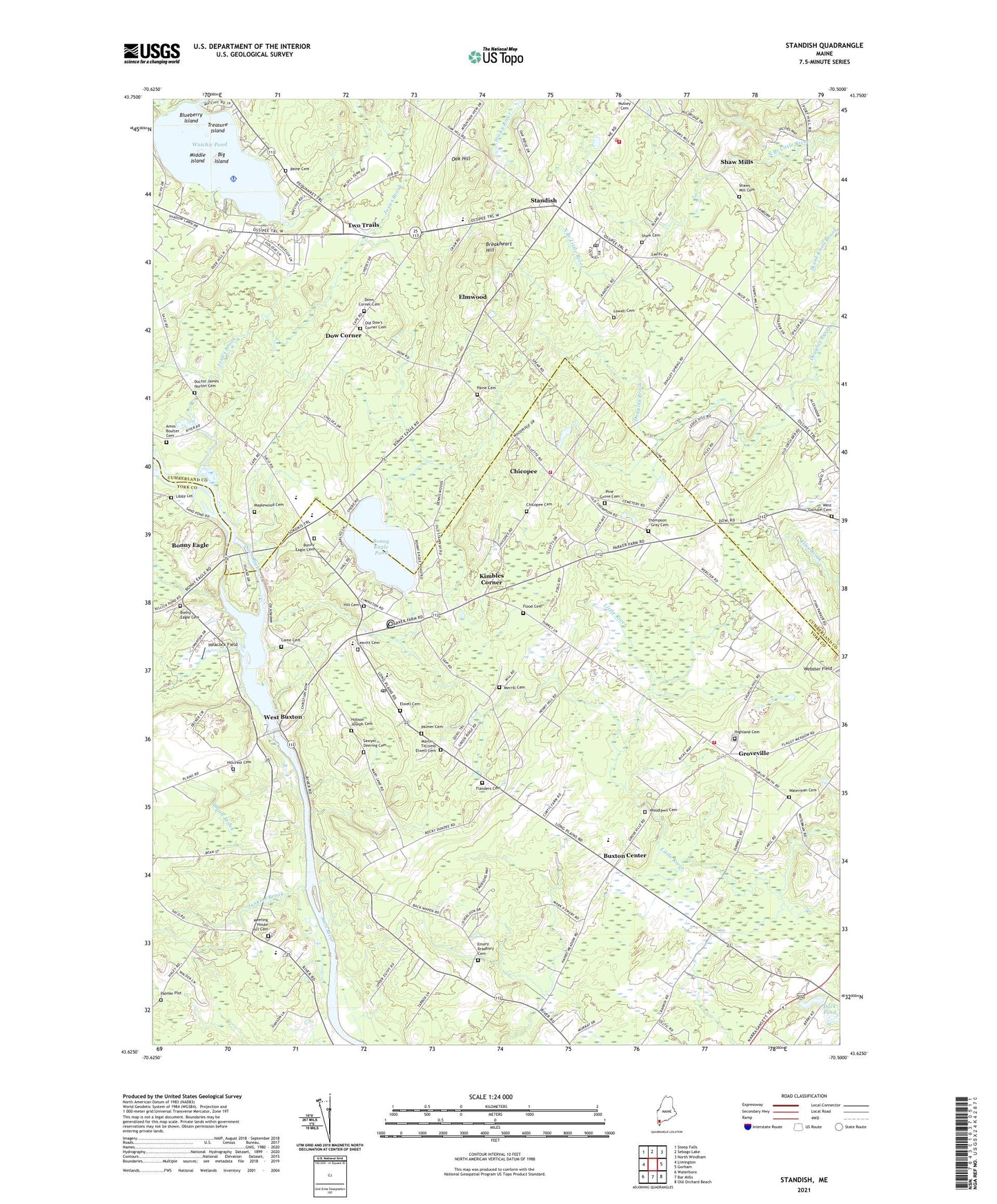
2024 topographic map quadrangle Standish in the state of Maine. Scale: 1:24000. Based on the newly updated USGS 7.5' US Topo map series, this map is in the following counties: York, Cumberland. The map contains contour data, water features, and other items you are used to seeing on USGS maps, but also has updated roads and other features. This is the next generation of topographic maps. Printed on high-quality waterproof paper with UV fade-resistant inks.
Quads adjacent to this one:
West: Limington
Northwest: Steep Falls
North: Sebago Lake
Northeast: North Windham
East: Gorham
Southeast: Old Orchard Beach
South: Bar Mills
Southwest: Waterboro
This map covers the same area as the classic USGS quad with code o43070f5.
Contains the following named places: Big Island, Blake School, Blueberry Island, Boggs Mill School, Bonney Eagle Dam, Bonny Eagle, Bonny Eagle Cemetery, Bonny Eagle High School, Bonny Eagle Middle School, Bonny Eagle Pond, Breakheart Hill, Buxton, Buxton Center, Buxton Center Baptist Church, Buxton Center Elementary School, Buxton Fire - Rescue Department Station 1, Buxton Fire - Rescue Department Station 3, Buxton Post Office, Came Cemetery, Chicopee, Chicopee Cemetery, Daniel Marrett House Museum, Dearborn School, Doctor James Norton Cemetery, Douglass Seaplane Base, Dow Corner, Dows Corner Cemetery, Duck Pond, Elmwood, Elwell Cemetery, Emery Bradbury Cemetery, Flanders Cemetery, Flood Cemetery, Frank Jewett School, George E Jack School, Groveville, Heacock Field, Highland Cemetery, Hill Cemetery, Hillcrest Cemetery, Hobson Joseph Cemetery, Hollis Elementary School, Hollis High School, Jack Memorial School, Josies Brook, Junkins Brook, Kimbles Corner, Leavitt Cemetery, Libby Lot, Living Waters Christian Church, Living Waters Christian School, Lowell Cemetery, Maplewood Cemetery, Martin - Titcomb Elwell Cemetery, Meeting House Hill Cemetery, Merrill Cemetery, Middle Island, Nfi North - Beacon House School, North Church, Oak Hill, Old Dow's Corner Cemetery, Old Red Church, Paine Cemetery, Palmer Cemetery, Palmer Plot, Pine Grove Cemetery, Saco River Reservoir, Samuel D Hanson School, Sawyer Deering Cemetery, Shadigee School, Shaw Cemetery, Shaw Mills, Shaws Mill Cemetery, Smith Brook, South Standish School, Standish, Standish Baptist Academy, Standish Census Designated Place, Standish Congregational Church, Standish Fire / EMS Department Central Station, Standish Post Office, Thompson - Gray Cemetery, Tory Hill Meeting House, Town of Buxton, Town of Hollis, Treasure Island, Two Trails, Tylers Corner, Watchic Pond, Waterman Cemetery, Webster Field, West Buxton, West Buxton Dam, West Buxton Public Library, West Gorham Cemetery, WLAM-AM (Gorham), Woodlawn Cemetery, ZIP Codes: 04042, 04093