MyTopo
Kennebunk Maine US Topo Map
Couldn't load pickup availability
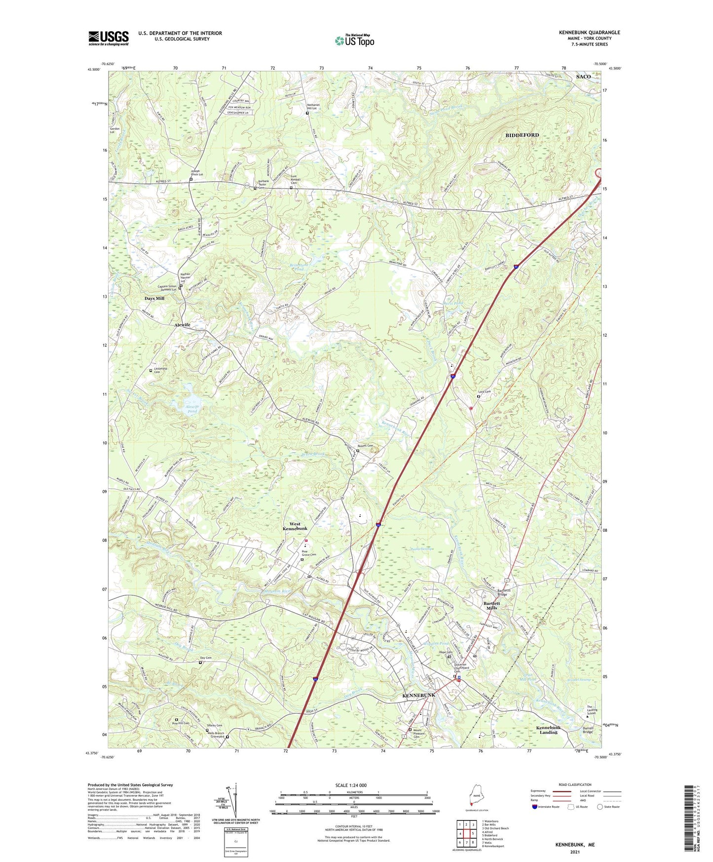
2024 topographic map quadrangle Kennebunk in the state of Maine. Scale: 1:24000. Based on the newly updated USGS 7.5' US Topo map series, this map is in the following counties: York. The map contains contour data, water features, and other items you are used to seeing on USGS maps, but also has updated roads and other features. This is the next generation of topographic maps. Printed on high-quality waterproof paper with UV fade-resistant inks.
Quads adjacent to this one:
West: Alfred
Northwest: Waterboro
North: Bar Mills
Northeast: Old Orchard Beach
East: Biddeford
Southeast: Kennebunkport
South: Wells
Southwest: North Berwick
This map covers the same area as the classic USGS quad with code o43070d5.
Contains the following named places: Alewife, Alewife Pond, Arundel Fire - Rescue Department, Arundel Skillings Community Residence Sweetser, Bartlett Mills, Bartletts Bridge, Bibber Memorial Chapel, Brick Store Museum, Brimstone Pond, Burbank Taylor Cemetery, Burnham School, Captain Simon Dennett Lot, Carlisle Brook, Christ Church, Davis Pond, Day Brook, Day Cemetery, Days Mill, Duck Brook, Durell School, Durrell Bridge, East Outlet, Edith Cleaves Barry Library, First Church of Christ Scientist, First Parish Unitarian Church, Full Gospel Church, Holy Cross Lutheran Church, Hope Cemetery, Irving School, Joseph Chick Lot, Kennebunk, Kennebunk Baptist Church, Kennebunk Census Designated Place, Kennebunk Elementary School, Kennebunk Fire and Rescue Central Station, Kennebunk Fire and Rescue West Kennebunk Station, Kennebunk Free Library, Kennebunk High School, Kennebunk Historic District, Kennebunk Landing, Kennebunk Police Department, Kennebunk Post Office, Kennebunk Recycling Center, Kennebunk Town Hall, Lafayette Park, LIttlefield Burial Lot 21, Littlefield Cemetery, Lord Cemetery, Lunt Kimball Cemetery, Middle School of the Kennebunks, Mildred L Day School, Mount Pleasant Cemetery, Mousam River Campground, Nathan Hanson Lot, Nathaniel Hill Lot, North Chapel, North Chapel School, Parsons Field, Pine Grove Cemetery, Punky Swamp, Rogers Park, Rotary Park, Russell Cemetery, Saint Andrews Presbyterian Church, Saint Monicas Catholic Church, Sea Road School, Shoppers Village Shopping Center, Storer Mansion, Sucker Brook, Swan Pond Creek, Taylor-Barry House, The Landing School, The New School, Town of Arundel, Town of Kennebunk, Tthe First Apostolic Church of Biddeford, Unitarian Churchyard Cemetery, Ward Brook, Wedding Cake House, West Kennebunk, West Kennebunk Census Designated Place, West Kennebunk Post Office, West Kennebunkport United Methodist Church, Wiggins Pond, Yankeeland Campground, ZIP Code: 04043