MyTopo
Phippsburg Maine US Topo Map
Couldn't load pickup availability
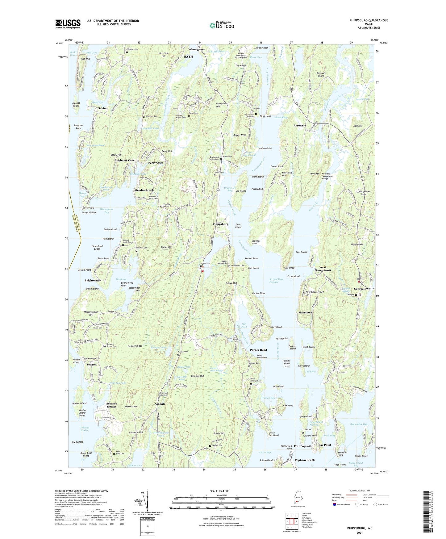
2021 topographic map quadrangle Phippsburg in the state of Maine. Scale: 1:24000. Based on the newly updated USGS 7.5' US Topo map series, this map is in the following counties: Sagadahoc, Cumberland. The map contains contour data, water features, and other items you are used to seeing on USGS maps, but also has updated roads and other features. This is the next generation of topographic maps. Printed on high-quality waterproof paper with UV fade-resistant inks.
Quads adjacent to this one:
West: Orrs Island
Northwest: Brunswick
North: Bath
Northeast: Westport
East: Boothbay Harbor
South: Small Point
Southwest: Bailey Island
Contains the following named places: Albert F Totman Library, Alfered Lee Farm Cemetery, Arrowsic, Arrowsic-Georgetown Bridge, Ashdale, Atkins Bay, Back Cove, Back River, Bald Head, Barlett Family Cemetery, Basin Island, Basin Point, Batchelder Hill, Bay Creek, Bay Point, Birch Point, Birchwood Pond, Blaisdell Pond, Bluff Head, Bowie Hill, Bragdon Rock, Bridge Hill, Brighams Cove, Brightwater, Burnt Coat Island, Bushy Island, Butler Cemetery, Campbell Pond, Clark Cemetery, Cox Head, Crow Islands, Cushman Hill, Cutting Creek, Dam Cove, Dam Cove Creek, Denny Reed Point, Dix Island, Dromore Cemetery, Drummond Cemetery, Drummond Cutting Cemetery, Drummore Bay, Dry Ledges, Duley Pond, Eaton Cemetery, Elbow Hill, Elwell Point, Fisher Eddy, Fort Baldwin State Historic Site, Fort Popham, Fort Popham Lighthouse, Fort Popham State Historic Site, Fred Wyman Cemetery, Fuller Mountain, Georgetown Central School, Georgetown Historical Society Library, Georgetown Island, Georgetown Post Office, Georgetown Volunteer Central Fire Station, Gilbert Head, Gilman and Bliston Cemetery, Goat Island, Green Point, Hall Hill, Harbor Island, Harbor Island Point, Harris Cemetery, Hatch Point, Heal Eddy, Hen Island, Hen Island Ledge, Higgins Mountain, Hillside Cemetery, Houghton Pond, Houghton Pond Dam, Hunnewell Point, Hutchins - Small Cemetery, Hutchins Cemetery, Indian Point, J R Clifford Cemetery, Jack Rock, Jennys Nubble, Kelley Family Cemetery, Kennebec Point, Lamb Island, Lee Cemetery, Lee Island, Lithgow Morse Farms Burying Ground, Lithgow Rock, Little Cox Head, Lombard Cemetery, Long Island, Long Island Narrows, Marine Cemetery, Marr Island, Marrtown, Meadowbrook, Meadowbrook Camping Area, Meetinghouse Hill, Meetinghouse Pond, Merritt Island, Merritt Mountain, Merry Cove, Mill Cove, Mill Pond, Minot Creek, Morse Cove, Newtown Creek, Newtown Hill, North Creek, North Sugarloaf Island, Oak Cemetery, Old Mica Mine, Old Mill Pond, Old West Bath Meeting House, Parker Flats, Parker Head, Parker Head Creek, Parker Head Swamp, Pasture Brook, Pasture Ridge, Perkins Island, Perkins Island Ledge, Perkins Island Light Station, Perry Cove, Perry Hill, Pettis Rocks, Phippsburg, Phippsburg Elementary School, Phippsburg Fire Station Rescue Department, Phippsburg Historical Museum, Phippsburg Police Department, Phippsburg Post Office, Phippsburg Town Office, Pitchpine Hill, Popham Beach, Ram Island, Ram Island Light, Reges Hill, Rich Hill, Rogers Neck, Rogers Neck Pond, Rogers Neck Pond Dam, Rollins Cemetery, Sabino, Sabino Head, Sagadahoc Bay, Sam Day Hill, Samuel Small Cemetery, Seal Island, Seal Rocks, Sebasco, Sebasco Estates, Sebasco Harbor, Sebasco School, Sebasco School Cemetery, Sewell Pond, Small Point Church, Sprague Pond, Squirrel Point, Squirrel Point Light Station, Striped Bass Passage, Swett Marsh, Tarrs Mountain, The Basin, The Reach, Timothy Bowker Cemetery, Todd Bay, Tottman Cove, Town of Arrowsic, Traffton Meadow, Wah-Tuh Lake, Wah-Tuh Lake Dam, Weasel Point, West Bath Church, West Georgetown, West Georgetown Hill, West Point Cemetery, West Point Church, West Point School, West Side Hill, William Rogers Cemetery, Winnegance, Winnegance Bay, Work Lee Cemetery, Wyman Bay, Wyman Cemetery, Wynburg, ZIP Code: 04562