MyTopo
Portland East Maine US Topo Map
Couldn't load pickup availability
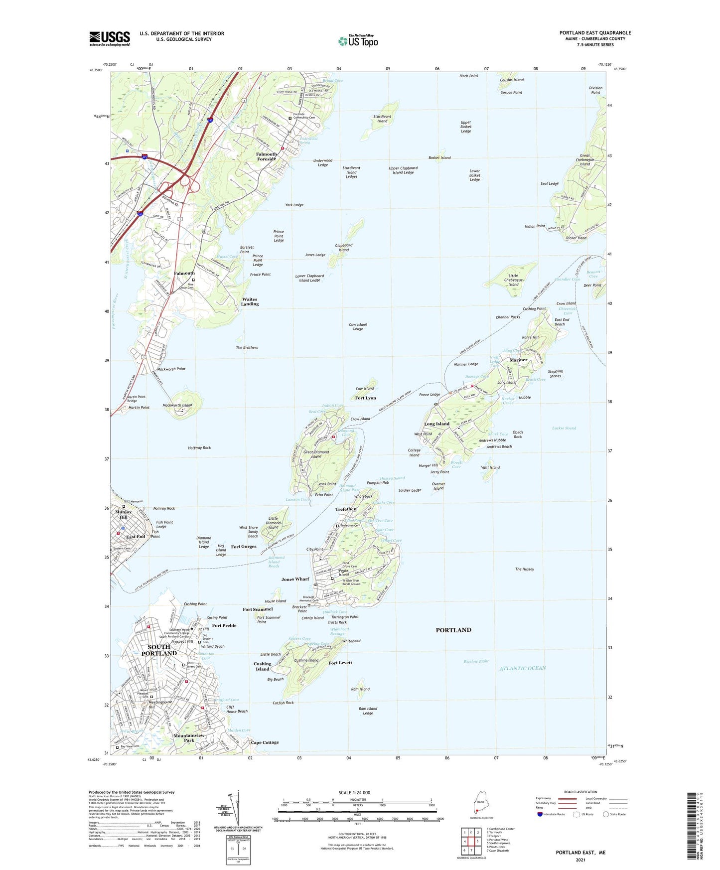
2021 topographic map quadrangle Portland East in the state of Maine. Scale: 1:24000. Based on the newly updated USGS 7.5' US Topo map series, this map is in the following counties: Cumberland. The map contains contour data, water features, and other items you are used to seeing on USGS maps, but also has updated roads and other features. This is the next generation of topographic maps. Printed on high-quality waterproof paper with UV fade-resistant inks.
Quads adjacent to this one:
West: Portland West
Northwest: Cumberland Center
North: Yarmouth
Northeast: Freeport
East: South Harpswell
South: Cape Elizabeth
Southwest: Prouts Neck
Contains the following named places: Andrews Beach, Andrews Nubble, Bartlett Point, Basket Island, Basket Island Light, Basket Island Preserve, Beach Cove, Bennett Cove, Big Beach, Brackett Memorial Cemetery, Brackett Point, Breakwater Marina, Broad Cove, Brown Elementary School, Cape Cottage, Casco Bay Ferry, Casco Bay Naval Auxiliary Air Facility, Catfish Rock, Catnip Island, Centerboard Yacht Club, Chandler Cove, Chandler Cove Landing, Channel Crossing Marina, Channel Rocks, Chebeague Island School, Chenery Brook, Chivericks Cove, City of Portland, City Point, Clapboard Island, Clapboard Island Light, Cleaves Landing, Cliff House Beach, Coast Guard Base South Portland, College Island, Cottage Farm School, Cow Island, Cow Island Ledge, Crow Island, Crow Island Light, Cushing Island, Cushing Island Landing, Cushing Point, Custom House Wharf, D W Lunt School, Danford Cove, Deer Point, Diamond Cove, Diamond Island Ledge, Diamond Island Pass, Diamond Island Roads, Division Point, Dora Small Elementary School, Dorseys Cove, Doughty Landing, East End, East End Beach, Echo Point, Echo Pond, Elm Tree Cove, Emerson School, Engineers Wharf, Evergreen Landing, Falmouth, Falmouth Census Designated Place, Falmouth Foreside, Falmouth Foreside Census Designated Place, Falmouth Shopping Center, Falmouth Town Forest, Ferry Village, First Civic Monument, Fish Point, Fish Point Ledge, Fore River, Foreside Community Cemetery, Forest City Landing, Forrest City Landing, Fort Allen Park, Fort Gorges, Fort Hill, Fort Levett, Fort Lyon, Fort McKinley Historic District, Fort Preble, Fort Scammel, Fort Scammel Point, Governor Baxter School for the Deaf, Great Diamond Island, Great Diamond Island Landing, Great Ledge Cove, Hadlock Cove, Halfway Rock, Harbor Grace, Henley School, Hill School, Hog Island Ledge, Holy Cross School South Portland, House Island, House Island Light, Hunger Hill, Hussey Sound, Hutchins School, Indian Cove, Indian Point, Jerry Point, Jones Landing Marina, Jones Ledge, Jones Wharf, Josiahs Cove, Kimball Brook, Lamson Cove, Little Beach, Little Chebeague Island, Little Diamond Island, Little Diamond Island Landing, Little Diamond Island Light, Little Diamond Island Observatory, Long Cove, Long Island, Long Island Elementary School, Loveitts Field, Lower Basket Ledge, Lower Clapboard Island Ledge, Luckse Sound, Mackworth Island, Mackworth Point, Maiden Cove, Maine State Pier, Marada Adams School, Marine Shipyard, Mariner, Mariner Ledge, Martin Point, Martin Point Bridge, McKinley Estates, Meetinghouse Hill, Mill Creek, Mount Pleasant Cemetery, Mountainview Park, Munjoy Hill, Mussel Cove, Norton Brook, Nubble, Obeds Rock, Old Port, Old Settlers Cemetery, Overset Island, Peaks Island, Peaks Island Elementary School, Peaks Island Ferry, Peaks Island Marina, Pine Grove Cemetery, Pine Grove Child Development Center, Pine Grove Child Development Center School, Plummer-Motz School, Pomroy Rock, Ponce Landing, Ponce Ledge, Pond Grove Cemetery, Portland Breakwater Light, Portland Country Club, Portland Harbor, Portland Municipal Boat Launch, Portland Observatory, Portland Yacht Services Complex, Presumpscot River, Prince Point, Prince Point Ledge, Prospect Hill, Pumpkin Knob Light, Pumpkin Nob, Ram Island, Ram Island Ledge, Ram Island Ledge Light Station, Ricker Head, Rock Point, Rohrs Hill, Roosevelt School, Scitterygusset Creek, Seal Cove, Seal Ledge, Shark Cove, Ship Cove, Simonton Cove, Soldier Ledge, South Portland, South Portland Municipal Boat Launch, Southern Maine Community College - South Portland Campus, Southern Maine Vocational Technical Institute Pier, Spar Cove, Spicers Cove, Spring Cove, Spring Point, Spring Point Ledge Lighthouse, Spring Point Marina, Spring Point Shoreway, Spruce Point, State Pier, Stepping Stones, Sturdivant Island, Sturdivant Island Ledges, Sunset Landing, Sunset Marina, The Brothers, The Hussey, Torrington Point, Trefethen, Trefethen Cemetery, Trotts Rock, Trout Brook, Underwood Ledge, Underwood School, Underwood Spring, United States Marine Hospital, Upper Basket Ledge, Upper Clapboard Island Ledge, Vaill Island, Waites Landing, West Point, West Shore Sandy Beach, Whaleback, Wharf Cove, Whitehead, Whitehead Passage, Willard Beach, Willard School, Willard Square, Wreck Cove, Ye Olde Trott Burial Ground, York Landing, York Ledge, ZIP Codes: 04050, 04108, 04109, 04110