MyTopo
South Harpswell Maine US Topo Map
Couldn't load pickup availability
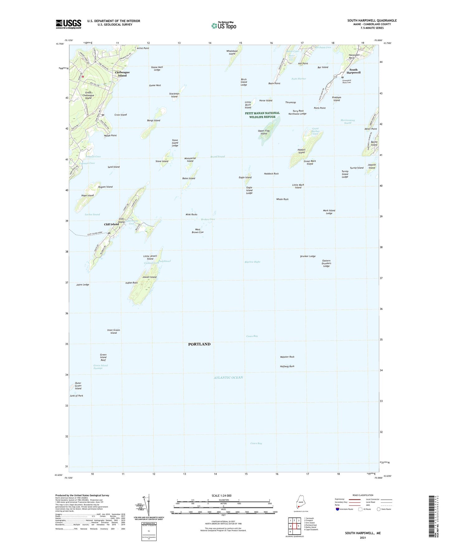
2024 topographic map quadrangle South Harpswell in the state of Maine. Scale: 1:24000. Based on the newly updated USGS 7.5' US Topo map series, this map is in the following counties: Cumberland. The map contains contour data, water features, and other items you are used to seeing on USGS maps, but also has updated roads and other features. This is the next generation of topographic maps. Printed on high-quality waterproof paper with UV fade-resistant inks.
Quads adjacent to this one:
West: Portland East
Northwest: Yarmouth
North: Freeport
Northeast: Orrs Island
East: Bailey Island
Southwest: Cape Elizabeth
This map covers the same area as the classic USGS quad with code o43070f1.
Contains the following named places: Abner Point, Admiral Robert E Peary Home Museum, Artist Point, Ash Point, Ash Point Cove, Bangs Island, Bar Island, Basin Point, Basion Cove Falls, Bates Island, Birch Island Ledge, Broad Sound, Broken Cove, Casco Bay, Central Landing, Chebeague Island, Chebeague Island Fire Department, Chebeague Island Library, Chebeague Island Post Office, Chebeague Island Rescue Squad, Cliff Island, Cliff Island Landing, Cliff Island Library, Cliff Island Post Office, Cliff Island School, Cocktail Cove, Coleman Cove, Crow Island, Drunker Ledge, Drunkers Ledge Beacon, Eagle Island, Eagle Island Ledge, Eastern Drunkers Ledge, Fishermans Cove, Goose Nest, Goose Nest Ledge, Graveyard Point Cemetery, Great Chebeague Golf Club, Great Chebeague Island, Great Harbor Cove, Great Mark Island, Green Island Passage, Green Island Reef, Haddock Rock, Halfway Rock, Halfway Rock Light, Harpswell Neck, Haskell Island, Hope Island, Horse Island, Indian Rock, Inner Green Island, Jaquish Gut, Jaquish Island, Jenks Landing, Jewell Island, Johns Ledge, Johnson Cove, Junk of Pork, Little Birch Island, Little Jewell Island, Little Mark Island, Lobstermans Statue, Mackerel Cove, Mark Island Ledge, Merriconeag Sound, Ministerial Island, Mink Rocks, Monument Light, Northwest Ledge, Outer Green Island, Pinkham Island, Potts Harbor, Potts Point, Punchbowl, Rogues Island, Sand Island, South Harpswell, Stave Island, Stave Island Ledge, Stockman Island, Thrumcap, Torry Rock, Town of Chebeague Island, Town of Long Island, Turnip Island, Turnip Island Ledge, Upper Flag Island, Waldo Point, Webster Rock, West Brown Cow, Western Landing, Whale Rock, ZIP Codes: 04017, 04019