MyTopo
Salsbury Cove Maine US Topo Map
Couldn't load pickup availability
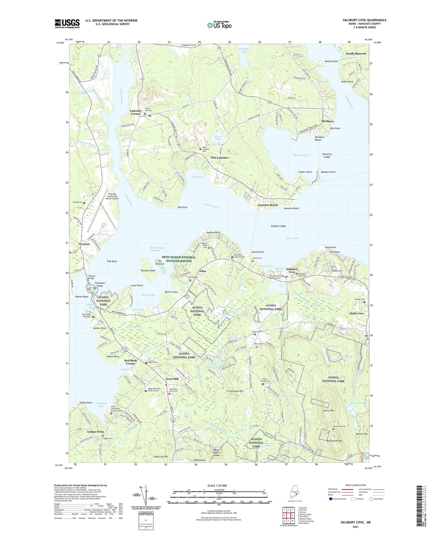
2021 topographic map quadrangle Salsbury Cove in the state of Maine. Scale: 1:24000. Based on the newly updated USGS 7.5' US Topo map series, this map is in the following counties: Hancock. The map contains contour data, water features, and other items you are used to seeing on USGS maps, but also has updated roads and other features. This is the next generation of topographic maps. Printed on high-quality waterproof paper with UV fade-resistant inks.
Quads adjacent to this one:
West: Newbury Neck
Northwest: Ellsworth
North: Hancock
Northeast: Sullivan
East: Bar Harbor
Southeast: Seal Harbor
South: Southwest Harbor
Southwest: Bartlett Island
Contains the following named places: Acadia Information Center, Acadia Zoo, Aunt Betseys Brook, Bar Harbor Ambulance Town Hill Station, Bar Harbor Campground, Bar Harbor Fire Department Town Hill Station, Bar Harbor Golf Course, Barcadia Camping Resort, Beaver Ponds, Berry Cove, Blagden Preserve, Blunts Point, Blunts Pond, Breakneck Brook, Breakneck Ponds, Burns Richardson Burial Ground, Church of Our Father Episcopal Church, Clark Cove, Crippens Brook, East Lamoine, East Lamoine Cemetery, Eastern Bay, Eden, Eden Baptist Church, Emery Cemetery, Emery Cove, Emery Family Burial Ground, Eno Pines, Fawn Pond, Federated Church, Forest Hill Cemetery, Fosters Brook, Fosters Pond, Fosters Pond Dam, Fountain of Life Foursquare Church, French Hill Brook, French Hill Pond, Frenchmans Hill, Fresh Meadow, Googins Ledge, Hadley Cemetery, Hadley Point, Hadley Point Cemetery, Hadleys Point Campground, Hamilton Pond, Hamilton Pond Dam, Hamilton Station, Hamilton Station Cemetery, Hancock County-Bar Harbor Airport, Haynes Point, Higgins Cemetery, Higgins Marcyes Burial Ground, Hillside Cemetery, Hulls Cove, Hulls Cove Post Office, Indian Point, Ireson Hill, Israel Point, Jones Marsh, Jordan River, Kitteredge Brook, Lake Wood, Lamoine Baptist Church, Lamoine Beach, Lamoine Beach Marina, Lamoine Consolidated School, Lamoine Corner, Lamoine State Park, Lamoine Volunteer Fire Department, Leland Cemetery, Leland Point, Long Heath, Marlboro, Marlboro Beach, McFarland Hill Trail, McFarland Mountain, Meadow Point, Mosely Point, Mount Desert Island Camping Resort, Mount Desert Island Laboratory, Mount Desert Narrows, Mountain View Cemetery, Narrows Too Camping Resort, Naval Auxiliary Air Station Bar Harbor, Negro Point, Newman Grave, Northeast Creek, Northwest Cove, Oceanarium Bar Harbor, Old County Road Cemetery, Old Mill Brook, Old Point, Oldhouse Cove, Paine Cemetery, Patty Lot Hill, Peach Family Cemetery, Pecks Point, Prays Brook, Raccoon Cove, Red Rock Corner, Salisbury Cove Cemetery, Salsbury Cove, Salsbury Cove Post Office, Salt Pond, Sand Point, Shooting Ledge, Skillings River, Spruce Point, Spruce Valley Campground, Stony Brook, Sunken Heath, The Heath, The Ovens, The Twinnies, Thomas Bay, Thomas Cemetery, Thomas Island, Thompson Island, Thompson Island Information Center, Timber Point, Town Hill, Town Hill Federated Church, Town of Bar Harbor, Town of Lamoine, Trap Rock, Trenton, Trenton Baptist Church, Trenton Bridge, Trenton Business Park, Trenton Elementary School, Trenton School, Trenton Town Offices, Trenton Volunteer Fire Department, West Eden Schoolhouse, Woodland Park Campground, Youngs Mountain, ZIP Codes: 04609, 04644