MyTopo
Ellsworth Maine US Topo Map
Couldn't load pickup availability
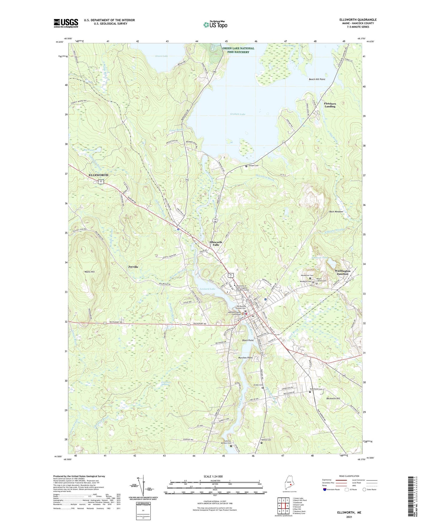
2024 topographic map quadrangle Ellsworth in the state of Maine. Scale: 1:24000. Based on the newly updated USGS 7.5' US Topo map series, this map is in the following counties: Hancock. The map contains contour data, water features, and other items you are used to seeing on USGS maps, but also has updated roads and other features. This is the next generation of topographic maps. Printed on high-quality waterproof paper with UV fade-resistant inks.
Quads adjacent to this one:
West: Branch Lake
Northwest: Green Lake
North: Beech Hill Pond
Northeast: Eastbrook
East: Hancock
Southeast: Salsbury Cove
South: Newbury Neck
Southwest: Blue Hill
This map covers the same area as the classic USGS quad with code o44068e4.
Contains the following named places: American Legion Hall, Archer Brook, Back Meadow, Beckwith Hill, Beech Hill Point, Beechland Cemetery, Big Pond, Birdsacre Wildlife Sanctuary, Black Point, Branch Lake Stream, Camp Dry-Kye, Card Brook, Christian Ridge Church of God, City of Ellsworth, Colonel Black Mansion Museum, County Ambulance, Cushmans Meadow, Day Brook, Deadman Brook, Doctor Charles C Knowlton School, Downeast Health Services, Ellsworth, Ellsworth Area Chamber of Commerce, Ellsworth Church, Ellsworth City Hall, Ellsworth Dam, Ellsworth Elementary Middle School, Ellsworth Falls, Ellsworth Fire Station, Ellsworth High School, Ellsworth Historical Society Building, Ellsworth Jail, Ellsworth Middle School, Ellsworth Police Department, Ellsworth Post Office, Ellsworth Power House, Ellsworth Public Library, Ellsworth Shopping Center, Ellsworth United Methodist Church, Ellsworth Water Company Dam, Ellsworth Waterford Park and Marina, Emmanuel Baptist Church, Family Bible Church, Federal Building, First Church of Christ Scientist, First Congregational Church, Fletchers Landing, Full Gospel Church, Fullerton Milliken Cemetery, General Bryant E Moore School, Gilpatrick Brook, Graham Lake Dam, Great Meadow, Green Lake National Fish Hatchery, Greys Brook, Hancock County Auditorium, Hancock County Cooperative Extension Service Building, Hancock County Courthouse, Hancock County Jail, Hancock County Law Library, Hancock County Regional Planning Commission, Hancock County Sheriff's Office, Hancock County Technical Center School, Hapworth Brook, Jordan Cemetery, Joyville, Juniper Cemetery, Kids Peace - Graham Lake Campus, Kidspeace National Centers of New England, Leonard Lake, Life Christian Academy, Little Meadow Brook, MacKenzie Cemetery, Maine Coast Mall Shopping Center, Maine Coast Memorial Hospital, Maine Department of Social Services, Maine State Department of Transportation Building, Maine State Police Troop J, Meadow Brook, Moore Brook, Mount Calvary Cemetery, Murches Point, Old Burying Ground Cemetery, Old Hancock County Building, Patten Stream, Puffin Square Mall Shopping Center, Rankin Brook, Remick Cemetery, Saint Andrew Lutheran Church, Saint Dunstans Episcopal Church, Saint Joseph Catholic Church, Saint Thomas Anglican Church, Sawpit Brook, Seventh Day Adventist Church, Shackford Brook, Simmons Pond, Stanwood Homestead Museum and Wildlife Sanctuary, Temple Christian Academy, The Church of Jesus Christ of Latter Day Saints, Timberland Acres Recreational Vehicle Park, Union Congregational Church of Ellsworth Falls, Unitarian Universalist Church, United Baptist Church, University of Maine Augusta Ellsworth Center, Washington Junction, Watts Hill, White Birches Golf Course, Whittaker Brook, Woodbine Cemetery