MyTopo
Bartlett Island Maine US Topo Map
Couldn't load pickup availability
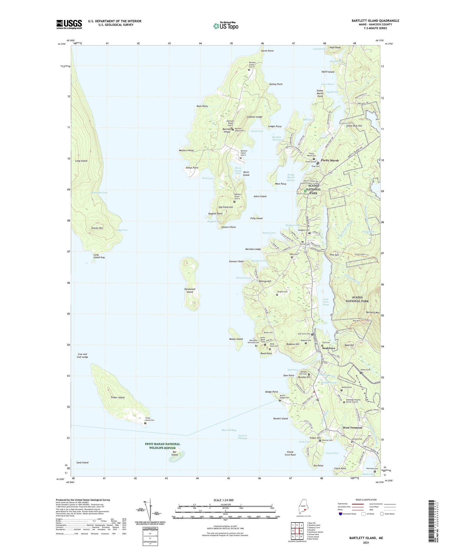
2024 topographic map quadrangle Bartlett Island in the state of Maine. Scale: 1:24000. Based on the newly updated USGS 7.5' US Topo map series, this map is in the following counties: Hancock. The map contains contour data, water features, and other items you are used to seeing on USGS maps, but also has updated roads and other features. This is the next generation of topographic maps. Printed on high-quality waterproof paper with UV fade-resistant inks.
Quads adjacent to this one:
West: Brooklin
Northwest: Blue Hill
North: Newbury Neck
Northeast: Salsbury Cove
East: Southwest Harbor
Southeast: Bass Harbor
South: Swans Island
Southwest: Stinson Neck
This map covers the same area as the classic USGS quad with code o44068c4.
Contains the following named places: Alleys Point, Auto Museum, Babbidge Murphy Burial Ground, Backside Redemption Church, Bald Hill, Bald Mountain, Bar Island, Bartlett Island, Bartlett Island Cemetery 1, Bartlett Island Cemetery 2, Bartlett Island Cemetery 3, Bartlett Island Cemetery 6, Bartlett Island Number 5 Cemetery, Bartlett Narrows, Benjamin Norwood Cemetery, Billings Hill, Birch Island, Birch Island Cove, Butlers Hill, Center, Center Cemetery, Center School, Clark Point, Cornerstone Church, Cow and Calf Ledge, Crystal Cove, Deep Cove, Dix Point, Dodge Point, Dogfish Cove, Dogfish Point, Dow Point, Duck Cove, Duck Cove Brook, Duck Pond, Duck Pond Brook, Dunhams Cove, Eastern Passage, Eastern Point, Flye Cemetery, Fogg Cove, Folly Island, Galley Point, Goose Cove, Goose Cove Rock, Goose Marsh, Goose Marsh Point, Goose Marsh Pond, Great Cove, Hardwood Island, High Head, Hillrest Cemetery, Hodgdon Brook, Hodgdon Cemetery, Hodgdon Pond, Hodgon Cove, James Reed Cemetery, Johns Island, Kelley Cemetery, Langley Cemetery, Latty Cove, Ledges Point, Long Island Hub, Lookout Ledge, Merman Ledge, Mill Cove, Moose Island, Murphy Cemetery, Murphy Hill, Murphy Hill Cemetery, Murphy Swamp, North Point, Norwood Cemetery, Norwood Ridge, Ober Cemetery, Old Field Hill, Pine Hill, Pomroy Cemetery, Pray Cemetery, Pretty Marsh, Pretty Marsh Cemetery, Pretty Marsh Harbor, Prettymarsh Picnic Area, Reed Point, Reed Point Cemetery, Robbins Cemetery, Robbins Hill, Rock Point, Round Pond, Rumell Island, Rumill Dodge Cemetery, Saint Andrews Church, Sand Island, Sawyers Cove, Seal Cove, Seal Cove Cemetery, Seal Cove Dam, Seal Cove Pond, Seal Cove Post Office, Smith Graves, Somes Cove, South Face Trail, Southwest Harbor Tremont Volunteer Ambulance Seal Cove, Squid Cove, Squid Island, Steves Hill, Steward Brook, Stewart Cove, Stewart Head, The Hub, Tinker Brook, Tinker Hill, Tinker Island, Tinker Island Cemetery, Town of Tremont, Tremont Church, Tremont Volunteer Fire Department Seal Cove Station, Uncle Dick Hill, Webster Brook, West Point, West Tremont, West Tremont Post Office, Western Point, ZIP Code: 04674