MyTopo
Southwest Harbor Maine US Topo Map
Couldn't load pickup availability
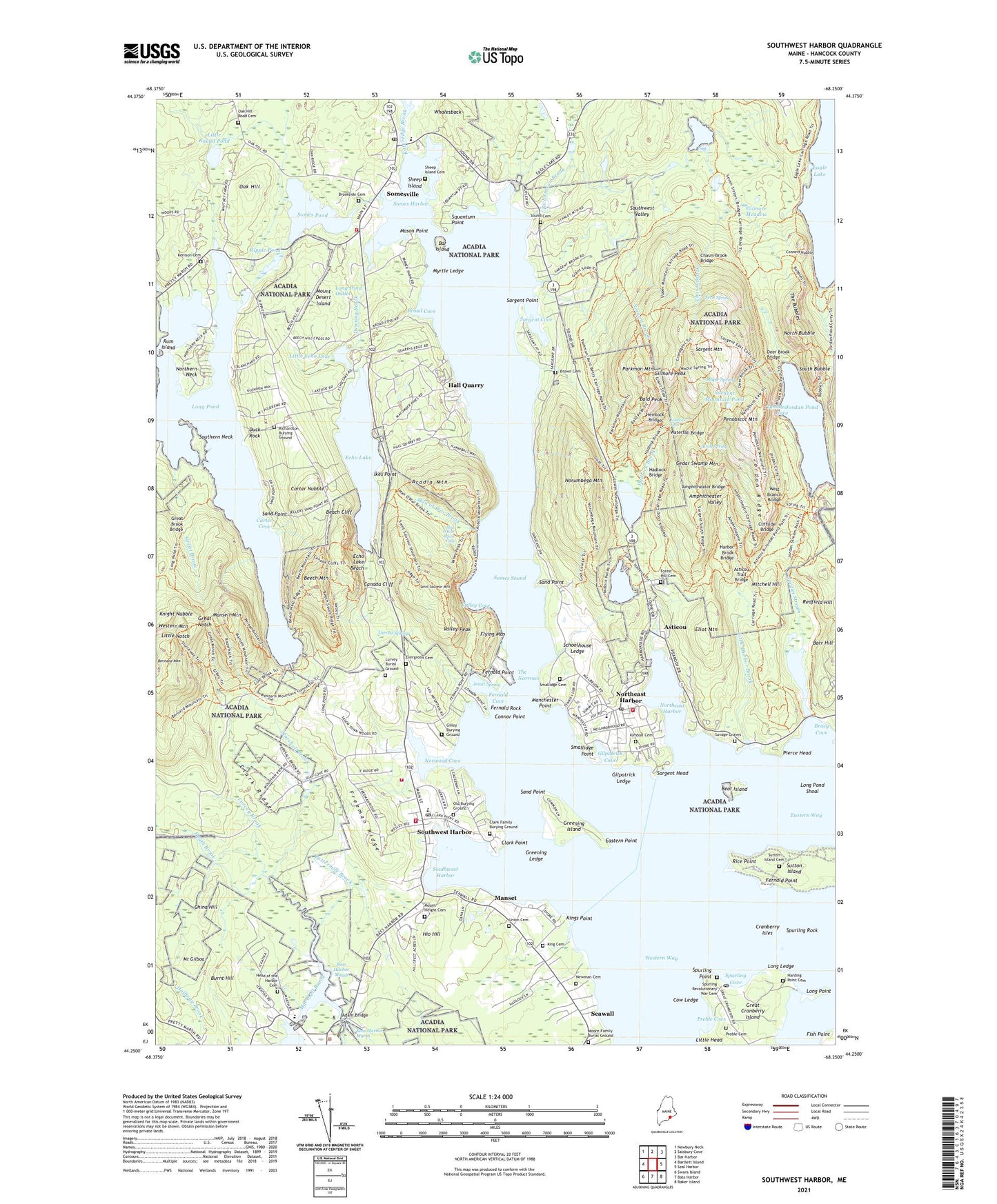
2024 topographic map quadrangle Southwest Harbor in the state of Maine. Scale: 1:24000. Based on the newly updated USGS 7.5' US Topo map series, this map is in the following counties: Hancock. The map contains contour data, water features, and other items you are used to seeing on USGS maps, but also has updated roads and other features. This is the next generation of topographic maps. Printed on high-quality waterproof paper with UV fade-resistant inks.
Quads adjacent to this one:
West: Bartlett Island
Northwest: Newbury Neck
North: Salsbury Cove
Northeast: Bar Harbor
East: Seal Harbor
Southeast: Baker Island
South: Bass Harbor
Southwest: Swans Island
This map covers the same area as the classic USGS quad with code o44068c3.
Contains the following named places: Acadia Mountain, Acadia Mountain Trail, Acadia National Park, Amphitheater Trail, Amphitheater Valley, Asticou, Asticou Azalea Garden, Asticou Landing, Asticou Terrace Dock, Asticou Terraces, Asticou Trail, Aunt Betty Pond, Bald Peak, Bald Peak Trail, Bar Island, Bass Harbor Marsh, Beach Cliff, Beals Wharf, Bear Island, Beech Cliff Ladder Trail, Beech Cliff Loop, Beech Mountain, Beech Mountain Trail, Beech Mountain West Ridge Trail, Bernard Mountain, Birch Spring Trail, Bracy Cove, Broad Cove, Brookside Cemetery, Browns Brook, Bubble Gap Trail, Burnt Hill, Buttermilk Brook, C J Halls Quarries, Canada Cliff, Canada Ridge Trail, Carter Cove, Carter Nubble, Causeway Golf Course, Cedar Swamp Mountain, Chasm Brook, China Hill, Clark Point, Clark Ridge, Clifton Dock, Coast Guard Station Southwest Harbor, Cold Brook Trail, Conners Nubble, Conners Nubble Trail, Connor Point, Cow Ledge, Cranberry Isles Town Dock, Deer Brook Trail, Denning Brook, Duck Rock, Eagle Lake, Eagle Lake Trail, Eastern Point, Echo Lake, Echo Lake Beach, Echo Lake Dam, Eliot Mountain, Eliot Mountain Trail, Fernald Cove, Fernald Point, Fernald Rock, Fish Point, Flying Mountain, Flying Mountain Trail, Forest Hill Cemetery, Freeman Ridge, Gilley Burying Ground, Gilley Field, Gilmore Meadow, Gilmore Peak, Gilpatrick Cove, Gilpatrick Ledge, Grandgent Trail, Great Brook, Great Long Pond Trail, Great Notch, Great Notch Trail, Greening Island, Greening Ledge, Hadlock Brook, Hadlock Brook Trail, Hadlock Falls, Hadlock Lower Dam, Hadlock Upper Dam, Hall Quarry, Harbor Brook Trail, Heath Brook, Hinckley Great Harbor Marina, Hio Hill, Ikes Landing, Ikes Point, Jordan Cliffs Trail, Jordan Pond, Jordan Pond East Side Trail, Jordan Pond Shore Trail, Jordan Pond Trail, Jordan Pond West Side Trail, Jordan Ridge, Jordan Stream, Kimball Cemetery, Kings Point, Knight Nubble, Little Echo Lake, Little Harbor Brook, Little Harbor Brook Trail, Little Head, Little Notch, Little Round Pond, Long Ledge, Long Point, Long Pond, Long Pond Dam, Long Pond Outlet, Long Pond Shoal, Lower Hadlock Pond, Lurvey Brook, Man of War Brook, Man O'War Brook Falls, Manchester Point, Mansell Mountain, Mansell Mountain Trail, Manset, Maple Spring Trail, Marshall Brook, Mason Point, Mill Field, Mitchell Hill, Mount Desert Campground, Mount Desert Island, Mount Desert Municipal Pier, Mount Desert Town Wharf, Mount Desert Yacht Yard, Mount Gilboa, Mount Height Cemetery, Myrtle Ledge, North Bubble, North Bubble Trail, North Ridge Trail, Northeast Harbor, Northeast Harbor Census Designated Place, Northeast Harbor Golf Course, Northeast Harbor Marina, Northern Neck, Norumbega Mountain, Norumbega Mountain Trail, Norwood Cove, Norwood Cove Dam, Oak Hill, Old Canada Cliff Trail, Old Spring Trail, Outer Beech Mountain Trail, Parkman Mountain, Parkman Mountain Trail, Penobscot Mountain, Penobscot Mountain Trail, Perpendicular Trail, Pierce Head, Preble Cemetery, Preble Cove, Razorback Trail, Rice Point, Richardson Brook, Ripple Pond, Rum Island, Saint Sauveur Mountain, Saint Saveur Mountain Trail, Sand Point, Sargent Brook, Sargent Cove, Sargent Head, Sargent Mountain, Sargent Mountain Pond, Sargent Mountain South Ridge Trail, Sargent Mountain Trail, Sargent Point, Schoolhouse Ledge, Seawall, Sheep Island, Sluiceway Trail, Smallidge Point, Smugglers Den Campground, Somes Harbor, Somes Pond, Somes Pond Outlet, Somes Pond Outlet Dam, Somes Sound, Somes Sound View Campground, Somesville, Somesville Historic District, Sound, South Bubble, South Bubble Trail, South Ridge Trail, Southern Neck, Southwest Harbor, Southwest Harbor Census Designated Place, Southwest Shoppes Plaza Shopping Center, Southwest Valley, Spurling Cove, Spurling Point, Spurling Rock, Squantum Point, Sutton Island, The Bubbles, The Narrows, Thuya Garden, Town of Mount Desert, Town of Southwest Harbor, Tremont, Tumbledown Cove, Union Cemetery, Upper Hadlock Pond, Valley Cove, Valley Cove Trail, Valley Peak, Valley Peak Trail, Valley Trail, Water Company Dam, Western Mountain, Western Mountain Ridge Trail, Western Mountain South Face Trail, Westside Market Plaza Shopping Center, Whalesback, White Birches Campground, Whiting and Allen Quarries, ZIP Codes: 04625, 04660, 04662, 04675, 04679