MyTopo
Annapolis Maryland US Topo Map
Couldn't load pickup availability
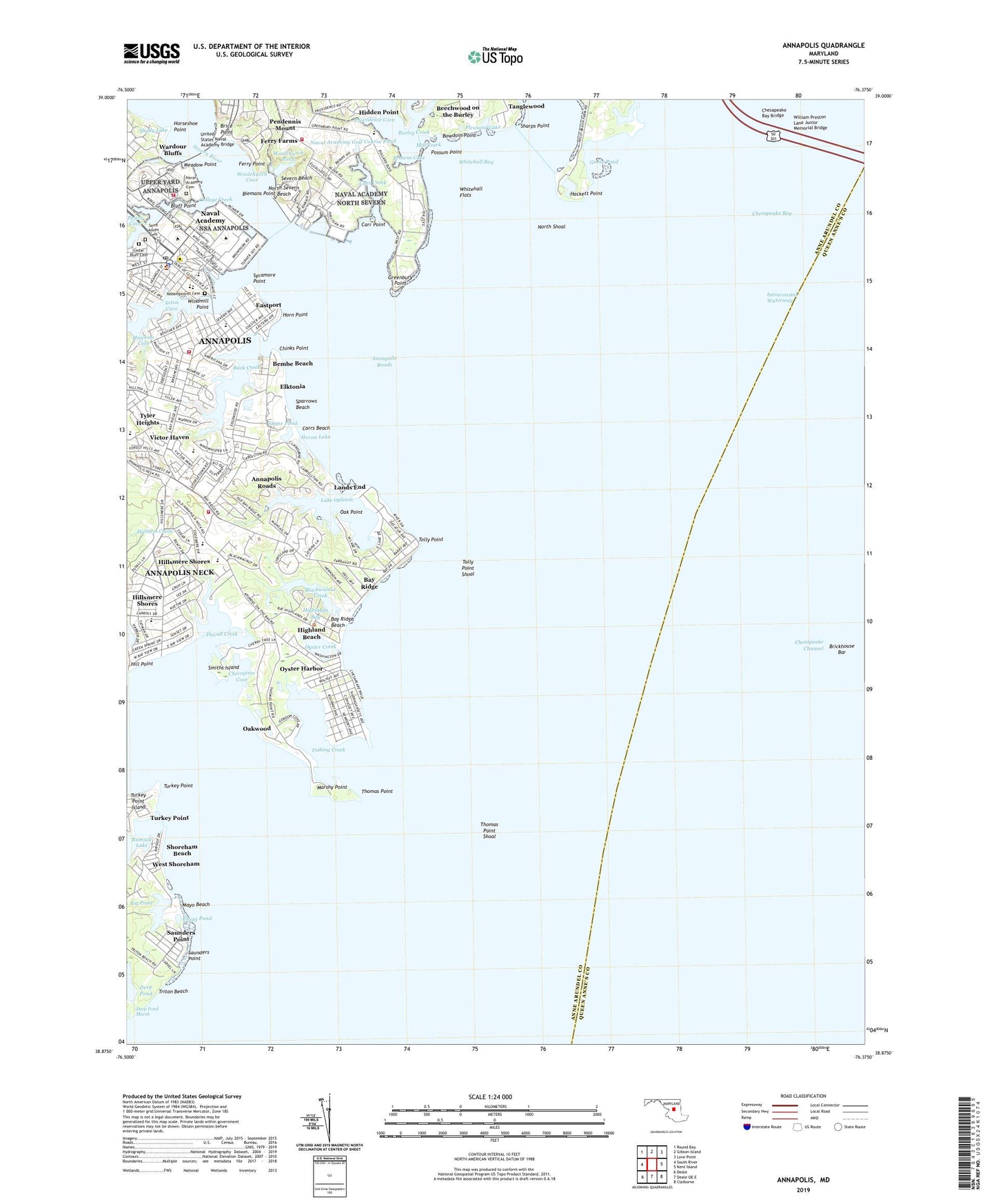
2023 topographic map quadrangle Annapolis in the state of Maryland. Scale: 1:24000. Based on the newly updated USGS 7.5' US Topo map series, this map is in the following counties: Anne Arundel, Queen Anne's. The map contains contour data, water features, and other items you are used to seeing on USGS maps, but also has updated roads and other features. This is the next generation of topographic maps. Printed on high-quality waterproof paper with UV fade-resistant inks.
Quads adjacent to this one:
West: South River
Northwest: Round Bay
North: Gibson Island
Northeast: Love Point
East: Kent Island
Southeast: Claiborne
South: Deale OE E
Southwest: Deale
This map covers the same area as the classic USGS quad with code o38076h4.
Contains the following named places: Acton Cove, Alumni Hall, Alumni House, Anchorage, Annapolis, Annapolis City Dock, Annapolis Cove, Annapolis Elementary School, Annapolis Golf Course, Annapolis Harbor, Annapolis Landing Marina, Annapolis Neck Census Designated Place, Annapolis Opera House, Annapolis Post Office, Annapolis Roads, Annapolis Roads Club, Annapolis Sailing School, Annapolis Yacht Basin, Annapolis Yacht Club, Anne Arundel County Courthouse, Arundel on the Bay, Arundel on the Bay Post Office, Back Creek, Bancroft Hall, Banneker-Douglass Museum of Afro-American Life and History, Bay Bridge Market Place Shopping Center, Bay Forest Shopping Center, Bay Ridge, Bay Ridge Beach, Bay Ridge Post Office, Bay View Heights, Beechwood on the Burley, Bembe Beach, Beverly-Triton Beach Park, Biemans Point, Big Pond, Blackwalnut Cove, Blackwalnut Creek, Bloomsbury Square, Bluff Point, Bowdoin Point, Brice Point, Brickhouse Bar, Browns Cove, Burley Creek, Campbell Parking Lot, Carr Creek, Carr Point, Carrs Beach, Cedar Bluff Cemetery, Chase Pond, Chase-Stone Parking Lot, Chauvenet Hall, Cherrytree Cove, Chesapeake Bay Bridge, Chesapeake Harbour, Chinks Point, Chrisland at Annapolis Cove, Church Circle, College Creek, Colonial Annapolis Historic District, Colonial Manor Estates, Colony Hills, Dahlgren Hall, Deep Pond Marsh, Dewey Field, Dungan Basin, Duvall Creek, Eastport, Eastport Elementary School, Eastport Post Office, Eastport Shopping Center, Eastport Terrace, Eastport-Annapolis Neck Branch Library, Elktonia, Farragut Field, Ferry Farms, Ferry Point, Fire Station Number 2, Fishing Creek, Fishing Creek Farms, Flagg Pond, Forrest Sherman Field, Fort Severn, Georgetown East, Georgetown East Elementary School, Goose Pond, Governors Mansion, Greenbury Point, Greenbury Point Shoal Light, Hackett Point, Hawkins Cove, Hendrix Oceanography Laboratory, Herndon Monument, Heron Lake, Hidden Point, Highland Beach, Highland Beach Post Office, Highlands Bay, Hill Point, Hillsmere Elementary School, Hillsmere Estates, Hillsmere Shores, Hillsmere Shores Census Designated Place, Horn Point, Horseshoe Point, Hubbard Hall, Ingram Field, John T Harrison Health Center, Jonas Green State Park, Key School, Keys Farm, King Hall, Kitty Creek, Lake Hillsmere, Lake Ogleton, Lands End, Leahy Hall, Little Burley Creek, Luce Hall, Macdonough Hall, Mahan Hall, Mariners Point, Market Place Shopping Center, Market Slip, Marshy Point, Maryland State House, Maryland World War II Memorial, Maury Hall, Mayo Beach, Mayo Beach Park, Meadow Point, Mears Marina, Mellon Parking Lot, Michelson Hall, Mill Creek, Mitscher Hall, Naval Academy Cemetery, Naval Academy Census Designated Place, Naval Academy Golf Course, Naval Academy Golf Course Pond, Naval Academy Museum, Naval Academy Post Office, Naval Academy Primary School, New Point, Nimitz Library, North Severn Beach, North Shoal, Oak Point, Oakwood, Old Annapolis Neck, Old Womans Cove, Olde Towne Marina, Oyster Creek, Oyster Harbor, Pendennis Mount, Peters Cove, Pleasant Lake, Port Annapolis Marina, Possum Point, Preble Hall, Providence, Providence Cove, Radford Terrace, Ramsay Lake, Redemptorist Cemetery, Rickover Hall, Ridge Park, Rip Miller Field, Robert Crown Sailing Center, Round View, Saint Annes Cemetery, Saint Annes Day School of Annapolis, Saint John's College, Saint Mary's Elementary School, Saint Mary's High School, Saint Marys Middle School, Sampson Hall, Santee Basin, Saunders Point, Seafarers Yacht Club, Severn Beach, Severn River, Shady Lake, Sharps Point, Shoreham Beach, Smiths Creek, Smiths Island, South River, Spa Creek, Spa Creek Anchorage, Sparrows Beach, Sycamore Point, Tanglewood, The Learning Community, Thomas Point, Thomas Point Park, Thomas Point Shoal, Thomas Point Shoal Lighthouse, Timber Creek, Tolly Point, Tolly Point Shoal, Town of Highland Beach, Triton Beach, Truxton Park, Turkey Point, Tyler Heights, Tyler Heights Elementary School, United States Naval Academy, United States Naval Academy Bridge, Van Buren Street Baptist School, Vandergrift Cutter Shed, Venice Beach, Victor Haven, Victualling Warehouse Maritime Museum, Walnut Lake, WANN-AM (Annapolis), Ward Hall, Wardour, Wardour Bluffs, Watergate, Watergate Village, West Annapolis, West Shoreham, Whitehall Bay, Whitehall Creek, Whitehall Flats, Wilshire, Windmill Point, Woolchurch Cove, Woolchurch Pond, Worden Field, Worthington Basin, ZIP Codes: 21402, 21403