MyTopo
Finksburg Maryland US Topo Map
Couldn't load pickup availability
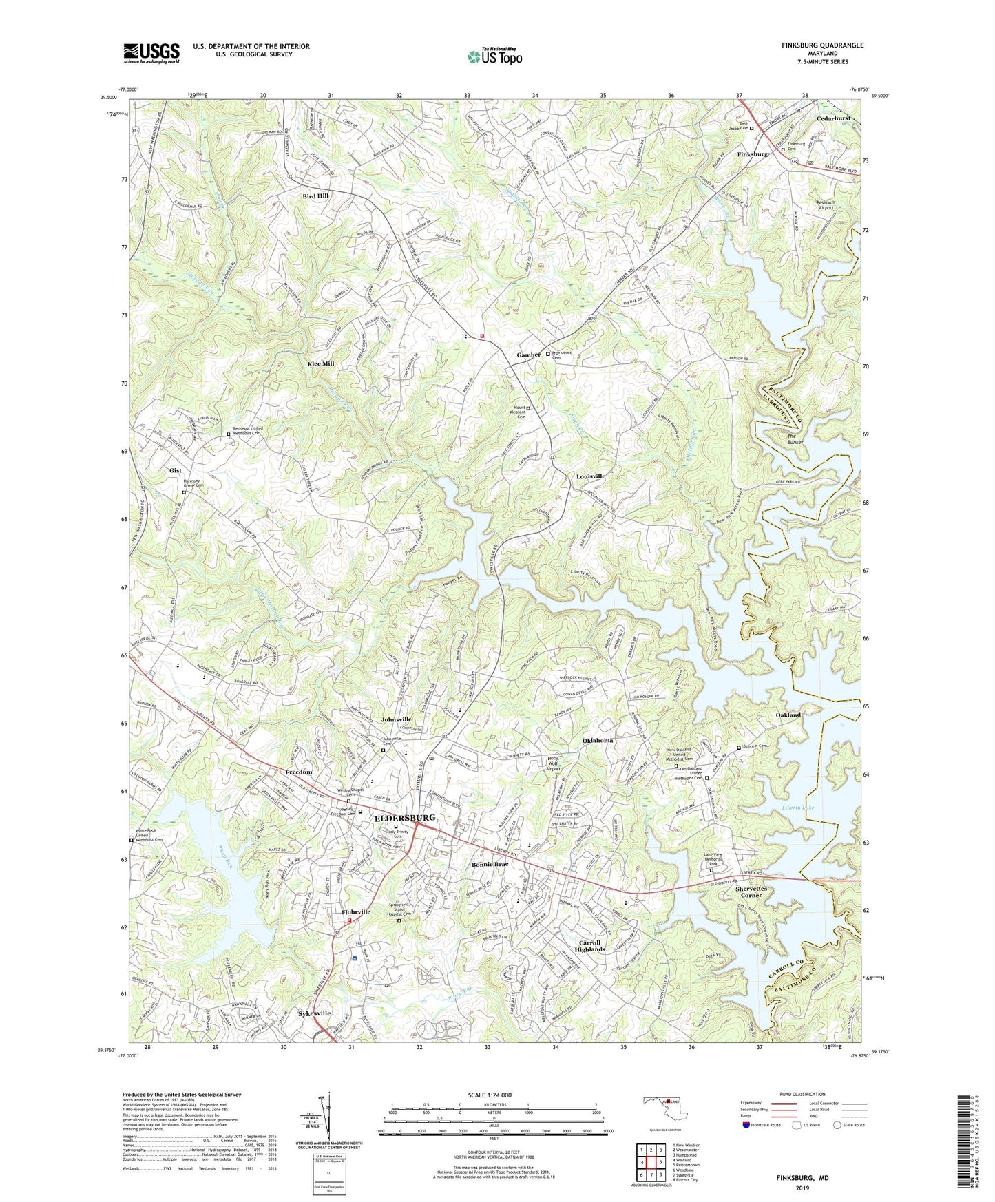
2023 topographic map quadrangle Finksburg in the state of Maryland. Scale: 1:24000. Based on the newly updated USGS 7.5' US Topo map series, this map is in the following counties: Carroll, Baltimore. The map contains contour data, water features, and other items you are used to seeing on USGS maps, but also has updated roads and other features. This is the next generation of topographic maps. Printed on high-quality waterproof paper with UV fade-resistant inks.
Quads adjacent to this one:
West: Winfield
Northwest: New Windsor
North: Westminster
Northeast: Hampstead
East: Reisterstown
Southeast: Ellicott City
South: Sykesville
Southwest: Woodbine
This map covers the same area as the classic USGS quad with code o39076d8.
Contains the following named places: Almond Valley, Arrington Estates, Babel Heights, Bar-Klee Estates, Beachmont Estates, Beaver Run, Beaver Run Fish and Game Club, Bennett Cemetery, Berkley Estates, Beth Jacob Cemetery, Bethesda Church, Bethesda United Methodist Cemetery, Bird Hill, Bird Hill Estates, Bollingers Mills, Bonnie Brae, Branton Manor, Brass Eagle Estates, Brimfield, Buckingham Manor, Candlewick, Carmae Acres, Carolyn Orchards, Carroll County Fire Department Station 12 Sykesville Freedom District Fire Department, Carroll County Fire Department Station 13 Gamber and Community Fire Company, Carroll County Gun Club, Carroll County Public Library - Eldersburg Branch, Carroll Dale, Carroll Highlands, Carroll Park, Carroll Square, Carroll Winde, Carrolltown Mall Shopping Center, Carrolltowne, Carrolltowne Elementary School, Cedarhurst, Centennial Homestead, Century High School, Charolais Acres, Cherry Corner, Cherry Tree Hills, Christiana Estates, Clipper Hill Estates, Cold Saturday, Collins Estates, Comet Roller Mills, Cooks Branch, Copper Ridge Nursing Home, Deep Valley, Deer Park Bible Church, Deer Park Estates, Deer Park Ridge, Dewberry Estates, District 5 Freedom, Eldersburg, Eldersburg Business Center, Eldersburg Census Designated Place, Eldersburg Elementary School, Eldersburg Plaza Shopping Center, Emerald Valley, Fairhaven, Fairhaven Assisted Living Center, Fieldcrest, Finksburg, Finksburg Cemetery, Finksburg Industrial Park, Finksburg Plaza Shopping Center, Finksburg Post Office, Flagg Meadows, Flohrville, Flohrville United Methodist Church, Folly Farms, Forest Hill Farms, Forest Oaks, Four Seasons, Freedom, Freedom Church, Freedom District Elementary School, Freedom Forest, Freedom Village, Friendship School, Gamber, Gill Estates, Gist, Grand View, Grassmere Estates, Greenleaf, Haight, Hammonds Estates, Harmony Grove Cemetery, Harmony Grove Church, Harvest Farms, Hawk Ridge, High Ridge, Hilltop, Hoby Wolf Airport, Holmes Park, Holy Trinity Cemetery, Holy Trinity Episcopal Church, Home Farm, Irongate, Joe Branch, Johnsville, Johnsville Cemetery, Johnsville Senior Citizens Center, Johnsville United Methodist Church, Ken-Mar Manor, Keysers Run, Kingdom Hall of Jehovahs Witnesses, Kirkner Estates, Klee Mill, Klees Mill Terrace, Knoll View Acres, Knollers Woods, Lake Hills, Lake View Memorial Park, Lakeland Heights, Lakeview, Lakeview Trailer Park, Lakeview Village, Liberty Dam, Liberty High School, Liberty Lake, Liberty Lake Hills, Liberty Manor, Liberty View Farms, Linton Springs, Linton Springs Elementary School, Little Morgan Run, Locust Run, London Bridge Estates, Long Meadows, Longview Heights, Louisville, Lynn Lee, Maple Haven, Marthas Legacy, Mechanicsville Elementary School, Melstone Valley, Merryman Heights, Middle River Volunteer Ambulance Rescue Company Station 52, Middle Run, Miners Ridge, Morgan Run, Morgan Run Environmental Area, Mount Pleasant Cemetery, Mount Pleasant Church, Mount Zion United Methodist Church, My Ladies Manor, New Oakland Church, New Oakland United Methodist Cemetery, Nicodemus Heights, Nora Valley, Norris Run, North Branch, Oakland, Oakland Hills, Oakland United Methodist Church, Obretch Estates, Oklahoma, Oklahoma Park, Oklahoma Road Middle School, Old Home Estates, Old Oakland United Methodist Cemetery, Parkfield, Parkside, Patriots Choice, Peach Mill Estates, Piney Ridge Elementary School, Piney Ridge Village, Piney Run Dam, Piney Run Lake, Piney Run Park, Piney Valley Estates, Presidential Park, Providence Cemetery, Providence Church, Prugh Branch, Red Oak Hills, Red Oak Hills West, Reservoir Airport, Ricketts Ridge, Ridgely Park, Ridgemar, Roaring Run Community Park, Rocky Acres, Saint Josephs Catholic Church, Saint Stephen's Classical Christian Academy, Sherlock Holmes Estates, Shervettes Corner, Ski Acres, South Carroll Commerce Park, South Carroll Commercial Park, South Carroll Medical Center, Springfield Hospital Center Post Office, Springfield Roller Mills, Springfield State Hospital Cemetery, Springfield State Hospital Center, Squires, Starview Estates, Strawbridge Estates, Strawbridge Home for Boys, Sumor Estates, Sunset Hill, Sweet Air, Sykesville Post Office, The Bunker, The Hemlocks, True Estates, Tylers Summit, Walnut Park Industrial Park, Waters Edge, Wellwood, Wesley - Freedom Cemetery, Wesley Chapel, Wesley Chapel Cemetery, White Pine Acres, White Pines Trailer Park, White Rock Church, White Rock United Methodist Cemetery, Wilson Terrace, Worth Acres, Wright Acres, Yellow Pine Estates, Zion Church, ZIP Codes: 21048, 21784