
MyTopo
Mechanicsville Maryland US Topo Map
Couldn't load pickup availability
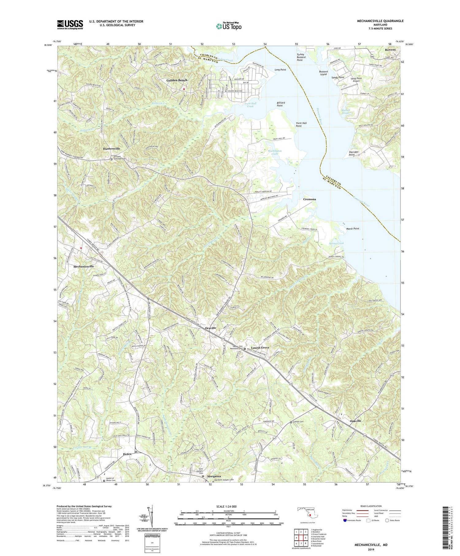
2019 topographic map quadrangle Mechanicsville in the state of Maryland. Scale: 1:24000. Based on the newly updated USGS 7.5' US Topo map series, this map is in the following counties: St. Mary's, Calvert, Charles. The map contains contour data, water features, and other items you are used to seeing on USGS maps, but also has updated roads and other features. This is the next generation of topographic maps. Printed on high-quality waterproof paper with UV fade-resistant inks.
Quads adjacent to this one:
West: Charlotte Hall
Northwest: Hughesville
North: Benedict
Northeast: Prince Frederick
East: Broomes Island
Southeast: Hollywood
South: Leonardtown
Southwest: Rock Point
Contains the following named places: All Faith Episcopal Cemetery, All Faith Episcopal Church, Big Oak, Billiard Point, Birch Manor, Burning Oaks, Buzzard Island, Buzzard Island Creek, Cellar Hill, Coatigan Run, Cooney Neck Estate, Cremona, Cremona Creek, De La Brooke, District 5 Mechanicsville, Dukes Wharf, Follywoods, Forrest Hall, Forrest Hall Estates, Galilee Cemetery, Galilee Church, Golden Beach, Golden Beach Census Designated Place, Gospel Light Baptist Academy, Gravely Knoll School, Harpers Corners, Helen, Helen Estates, Helen Farmettes, Helen Post Office, Hidden River, Holly Acres, Horse Landing, Horse Landing Creek, Huntersville, Immaculate Conception Catholic Church, Indian Creek, Indian River Estates, Killpeck Creek, King-Kennedy Estates, Laurel Grove, Laurel Grove Park, Leming, Living Word Community Church, Locks Swamp Creek, Long Point, Loveville Acres, Margaret Brent Middle School, Marsh Point, Mechanicsville, Mechanicsville Census Designated Place, Mechanicsville Volunteer Fire Department Company 2, Mechanicsville Volunteer Fire Department Company 22, Mechanicsville Volunteer Rescue Squad, Morganza, Morsell Creek, Mother Catherine Spalding Elementary School, Mount Zion Methodist Cemetery, Mount Zion United Methodist Church, Mud Creek, Oaks School, Oakville, Oakville Elementary School, Oakville Post Office, Old Saint Joseph's Cemetery, Oraville, Oraville Post Office, Parson Home, Patuxent Knolls, Persimmon Creek, Pinemore, Queen of Peace Cemetery, Quiet Acres, Reeder Wharf, Rolling Acres, Rustic Hills, Saint Joseph Catholic Church, Saint Joseph's Cemetery, Saint Marys Abbey, Sandy Point, Sandy Point Airport, Shady Dale, Sheridan Point, Spaldings Comfort, Spring Creek, Summerseat, Summerseat Village, Tenn Wood Acres, The Plains, Trent Hall, Trent Hall Creek, Trent Hall Point, Trent Hall Wharf, Turkey Buzzard Point, Washington Creek, Westfield, Widow Woods, ZIP Code: 20659


