MyTopo
Rock Point Maryland US Topo Map
Couldn't load pickup availability
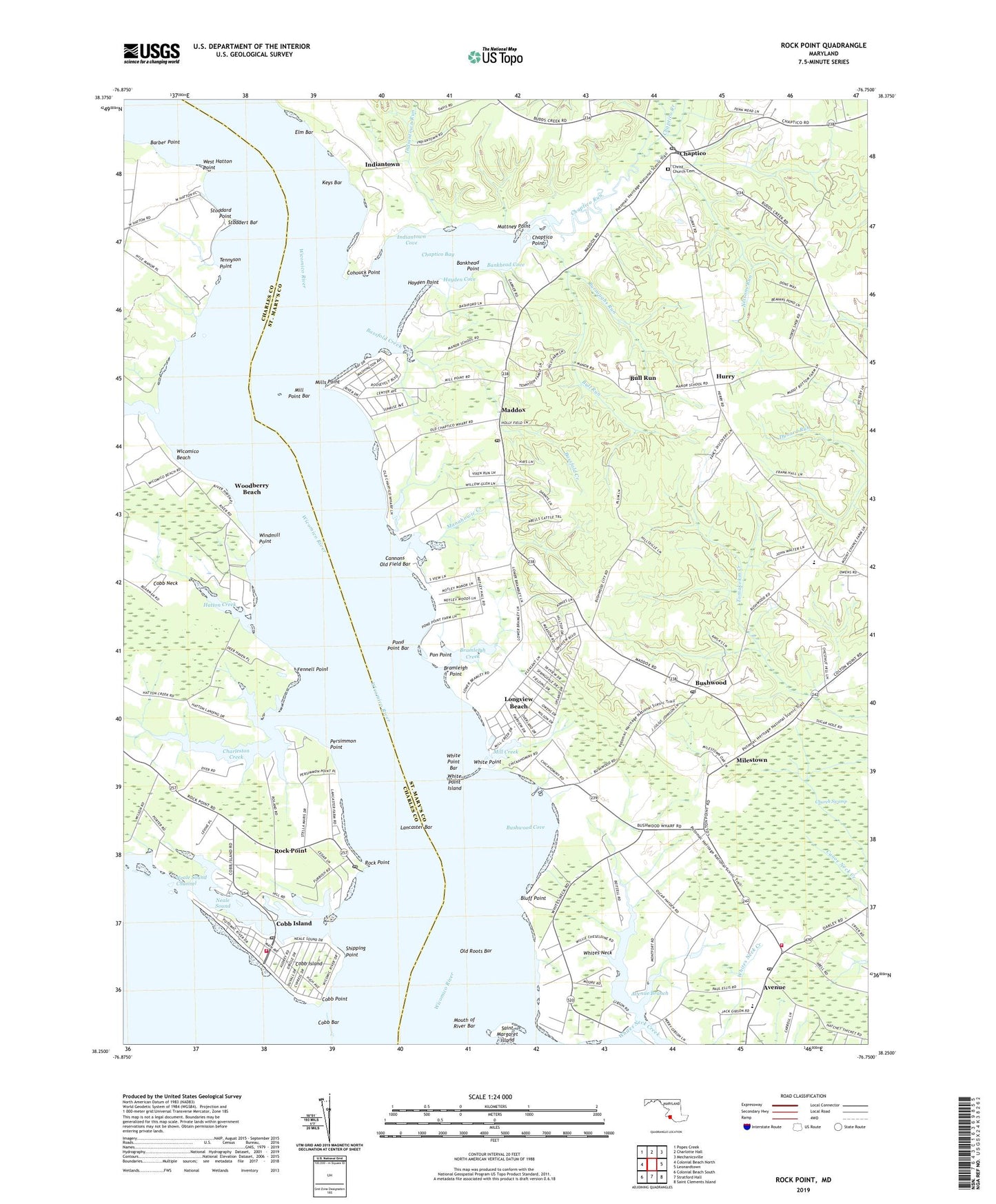
2023 topographic map quadrangle Rock Point in the state of Maryland. Scale: 1:24000. Based on the newly updated USGS 7.5' US Topo map series, this map is in the following counties: St. Mary's, Charles. The map contains contour data, water features, and other items you are used to seeing on USGS maps, but also has updated roads and other features. This is the next generation of topographic maps. Printed on high-quality waterproof paper with UV fade-resistant inks.
Quads adjacent to this one:
West: Colonial Beach North
Northwest: Popes Creek
North: Charlotte Hall
Northeast: Mechanicsville
East: Leonardtown
Southeast: Saint Clements Island
South: Stratford Hall
Southwest: Colonial Beach South
This map covers the same area as the classic USGS quad with code o38076c7.
Contains the following named places: Abell School, Anglican Chapel, Avenue, Avenue Branch, Avenue Post Office, Bachelors Hope, Bankhead Cove, Bankhead Point, Barber Point, Barbers Quarter, Basford Manor, Bassfold Creek, Bethune Elementary School, Blairs Purchase, Blakistone, Bloomfield, Bluff Point, Bramleigh Creek, Bramleigh Point, Bull Run, Burroughs Run, Bushwood, Bushwood Cove, Bushwood Lodge, Bushwood Manor House, Bushwood Post Office, Bushwood Wharf, Camp Saint Charles, Cannons Old Field Bar, Chaptico, Chaptico Bay, Chaptico Creek, Chaptico Point, Chaptico Post Office, Chaptico Run, Chaptico Wharf, Charleston Creek, Christ Church, Christ Church Cemetery, Church Swamp, Clover Dale Acres, Cobb Bar, Cobb Island, Cobb Island Census Designated Place, Cobb Island Post Office, Cobb Island Volunteer Fire Department and Emergency Medical Services, Cobb Point, Coffee Hill Run, Cohouck Point, Deep Falls, Denby Hill, District 4 Chaptico, Dolly Boarmans Creek, Dynard Elementary School, Elm Bar, Fennell Point, Fenwick School, Fosters Neck, Gravelly Hills, Green Springs, Hatchs Thicket, Hatton Creek, Hayden Cove, Hayden Point, Holy Angels Church, Holy Angels School, Hurry, Hurry Post Office, Indiantown, Indiantown Cove, Indiantown Run, Issue Post Office, Keys Bar, Lancaster Bar, Lancaster Wharf, Longview Beach, Loretano, Lower Brambley, Maddox, Maddox Creek, Maddox Post Office, Maiden Bower, Manahowic Creek, Mattapany Plantation, Mattney Point, Milestown, Mill Creek, Mill Point, Mill Point Bar, Mill Point Shores, Mills Point, Mouth of River Bar, Neale Sound, Neale Sound Channel, Neales Hill, Nelsons Run, Notley Hall, Nyce Airport, Ocean Hall, Old Roots Bar, Old Wharf Landing, Our Lady of the Wayside Church, Our Ladys Manor, Penerine, Persimmon Point, Pirates Den Marina, Pon Point, Pond Point Bar, Ridgewood, Rock Point, Rock Point Census Designated Place, Rock Point Post Office, Russell Landing, Sacred Heart Catholic Church, Sacred Heart Church, Sacred Heart Parochial School, Saint Catherine, Saint Margaret Island, Savona, Second District Volunteer Company and Rescue Squad 6, Seventh District Community Park, Seventh District Volunteer Fire Department Company 5, Seventh District Volunteer Rescue Squad, Shipping Point, South Hampton, Squier Landing, Stoddard Point, Stoddert Bar, Tennyson Point, The Glebe, Upper Brambley, West Hatton, West Hatton Point, White Point, White Point Bar, White Point Island, Whites Neck, Whites Neck Creek, Whites Neck Point, Wicomico Beach, Wicomico River, Willow Glen, Windmill Point, Woodberry Beach, Yellow Bank, ZIP Codes: 20609, 20618, 20621, 20625