MyTopo
Framingham Massachusetts US Topo Map
Couldn't load pickup availability
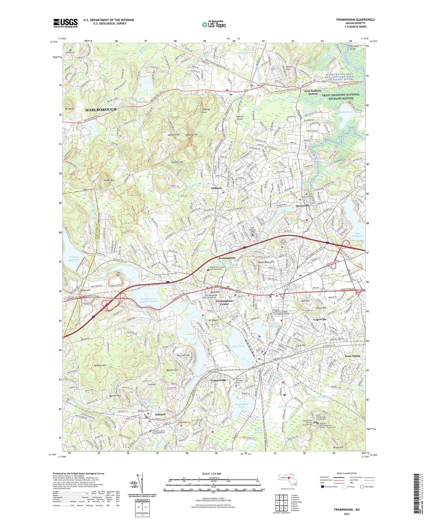
2021 topographic map quadrangle Framingham in the state of Massachusetts. Scale: 1:24000. Based on the newly updated USGS 7.5' US Topo map series, this map is in the following counties: Middlesex, Worcester. The map contains contour data, water features, and other items you are used to seeing on USGS maps, but also has updated roads and other features. This is the next generation of topographic maps. Printed on high-quality waterproof paper with UV fade-resistant inks.
Quads adjacent to this one:
West: Marlborough
Northwest: Hudson
North: Maynard
Northeast: Concord
East: Natick
Southeast: Medfield
South: Holliston
Southwest: Milford
Contains the following named places: 1776 Plaza Shopping Center, Angelica Brook, Anna Murphy Playground, Ashland, Ashland High School, Ashland Reservoir Dam, Ashland Square Shopping Center, Ashland Station, Baiting Brook, Ballard Hill, Banner Hill, Bannister Brook, Barbieri Elementary School, Bare Hill, Beaverdam Brook, Beth Am School, Beth Sholom School, Birch Meadow Brook, Blanford Pond, Bowditch Field, Boy Scout Reservation, Bracket Reservoir (Number Two), Brook Water School, Brophy School, Brown Elementary School, Brown School, Brush Hill, Brush Hill Burying Ground Cemetery, Burbank Circle Playground, Butterworth Park, Carding Millpond, Center School, Central Street Dam, Charlotte A Dunning School, City of Framingham, Clara Barton Burying Ground Cemetery, Clark Hill, Cloverleaf Marketplace Shopping Center, Coburnville, Cochituate Brook, Cochituate Heliport, Cochituate Station, Cold Spring Brook, Cold Spring Pond, Cole School, Colonial Shopping Center, Columbia Metrowest Medical Center, Concord Square Historic District, Costanza Park, Course Brook, Cowassock Brook, Cushing General Hospital, Danforth Square Playground, David Mindess Middle School, Dennison Playground, Digital Heliport, Doeskin Hill, Drury Hill, Dudley Brook, Eames Brook, East Sudbury Station, Edgebrook Nursery School, Edgell Grove Cemetery and Mausoleum, Edwards Cemetery, Fairbanks Road Playground, Farm Pond, Fiddlers Green Dam, First National Shopping Center, Fish Hill, Flagg Drive Middle School, Foss Reservoir (Number Three), Foss Reservoir Dam, Framingham, Framingham Census Designated Place, Framingham Center, Framingham Centre Common Historic District, Framingham Industrial Park, Framingham Mall Shopping Center, Framingham Memorial School, Framingham North High School, Framingham Plaza, Framingham Plaza Shopping Center, Framingham Reservoir Number Three, Framingham Shoppers World Shopping Center, Framingham South High School, Framingham State College, Framingham Station, Framingham Union Hospital, Frank G Feeley Park, Gibbs Mountain, Gleason Pond, Green Hill, Grist Millpond, Guinea Meadow, Guinea Meadow Swamp, Hager Pond, Hastings School, Heard Pond, Hemenway School, Hop Brook, Horse Pond Road School, Indian Brook, Indian Head Hill, Irving Square Historic District, Israel Loring School, J F Kennedy Middle School, Joseph P Keefe Technical High School, Juniper Hill, Juniper Hill School, Kennedy Junior High School, Lake Cochituate, Lake Cochituate Dam, Lakewood Country Club, Lamb Hill, Landham Brook, Lawrence Street School, Learned Pond, Learning Center for Deaf Children, Lincoln Junior High School, Lincoln School, Lokerville, Long Playground, Longs Playground, Loring Arena, Magunco Hill, Marian High School, Marist College, Marlborough Sewage Disposal, Mary E Stapleton School, Massachusetts Fire Academy, Massachusetts State Hospital, Massachusetts State Muster Ground, Massachusetts State Polic Academy, Maynard School, Merriam Hill, MetroWest Christian Academy, MetroWest Jewish Day School, Mill Pond Dam, Mill Village Shopping Center, Millwood Farms Golf Club, Miriam F McCarthy School, Mount Ward, Mount Wayte, Natick Army Laboratories Heliport, Natick Mall, Natick Mall Shopping Center, New England Center for Children School, Nobscot, Nobscot Hill, Nobscott Shopping Center, Norton Pond, Old Burying Ground Cemetery, Old Town Bridge, Old Trolley Square, Old Trolley Square Shopping Center, Packard Dam, Pincushion Hill Montessori School, Pinefield Shopping Center, Pod Meadow, Potter Road School, Reardon Park, Redstone School, Regis College, Regis College Framingham Campus, Reservoir Number 1 Dam, Reservoir Number 2 Dam, Reservoir Pond, Richard Callahan State Park, Romeos Shopping Center, Roosevelt School, Round-Up Shopping Center, Route 30 Mall, Route 30 Mall Shopping Center, Saint George Cemetery, Saint Stephen's Cemetery, Saint Stephens School, Saint Tarcisius Cemetery, Saint Tarcisius School, Saxonville, Sheperd Knapp School, Sherborn Reformatory for Women - Annex Cemetery, Sherwood Plaza Shopping Center, Simpson Park Playground, Sons of Mary Seminary, South School, South Sudbury, State Correctional Institution, Stearns Reservoir (Number 1), Steep Brook, Stone Park, Sucker Pond, Sucker Pond Playground, Sudbury Airport, Sudbury Aqueduct Linear District, Sudbury Crossing Shopping Center, Sudbury Dam, Sudbury Dam Historic District, Sudbury Industrial Park, Sudbury Plaza, Sudbury Pond, Sudbury River Dam, Sudbury River Reservoir, Sudbury Shopping Center, The Mountain, Tippling Rock, Tom Hill, Town of Ashland, Town of Framingham, Warren-Oak School, Waushakum Pond, Wayland Country Club, Wayland High School, Wayside Plaza, Wayside Plaza Shopping Center, WBIV-AM (Natick), WDJM-FM (Framingham), Weeks Cemetery, West Natick, West Natick Station, West School, Wildcat Hill, Wildwood Cemetery, William Pittaway Elementary School, William S Walsh Middle School, Willow Brook, Wilson School, Winch Park Junior High School, Winch Park Playground, WKOX-AM (Framingham), Woodfield Playground, ZIP Codes: 01701, 01702, 01721, 01745, 01778