MyTopo
Maynard Massachusetts US Topo Map
Couldn't load pickup availability
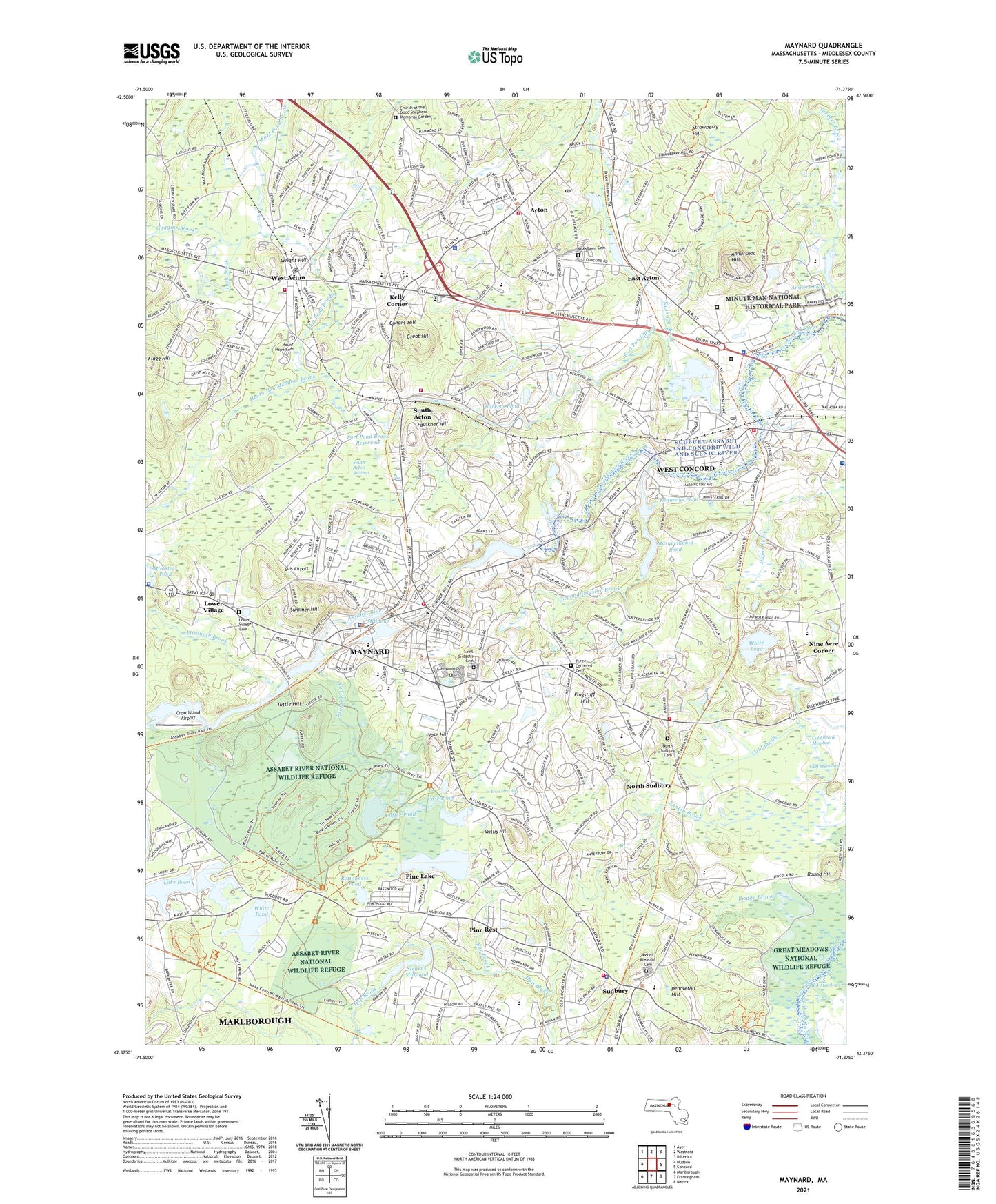
2024 topographic map quadrangle Maynard in the state of Massachusetts. Scale: 1:24000. Based on the newly updated USGS 7.5' US Topo map series, this map is in the following counties: Middlesex. The map contains contour data, water features, and other items you are used to seeing on USGS maps, but also has updated roads and other features. This is the next generation of topographic maps. Printed on high-quality waterproof paper with UV fade-resistant inks.
Quads adjacent to this one:
West: Hudson
Northwest: Ayer
North: Westford
Northeast: Billerica
East: Concord
Southeast: Natick
South: Framingham
Southwest: Marlborough
This map covers the same area as the classic USGS quad with code k42071d3.
Contains the following named places: Acton, Acton Arboretum, Acton Centre Historic District, Acton Christian Church, Acton Congregational Church, Acton Fire Department District 2, Acton Fire Department District 3, Acton Fire Station District 1, Acton Korean Church, Acton Mall, Acton Memorial Library, Acton Plaza, Acton Plaza Shopping Center, Acton Police Station, Acton Post Office, Acton Shopping Center, Acton Town Hall, Acton-Roxborough Regional High School, Allen Dam, Angiers Pond, Annursnac Hill, Assabet Plaza, Assabet River at High Street Dam, Assabet River National Wildlife Refuge, Assabet River Reservoir, Barkers Pond, Barretts Mill Road Dam, Baybank Plaza Shopping Center, Ben Smith Dam, Bottomless Pond, Bridge Brook, Bridge Brook Swamp, Citizens Library Association of West Acton, Cold Brook, Cold Brook Meadow, Community Gardens, Conant Hill, Conant School Library, Concord Country Club, Concord Fire Department Station 2, Concord Junction, Concord Reformatory, Concord-Acton Industrial Park, Congregation Beth El, Corwin-Russell School at Broccoli Hall, Crow Island Airport, Cutting Pond, Damon Mill, Damons Mills Westvale, Derby Orchard, Digital - Powdermill Heliport, Digital Heliport, Digital Heliport - Boxboro, Discovery Museum, East Acton, Elizabeth Brook, Elm Street Playground, Emerson Hospital, Emerson Hospital Library, Ephraim Curtis Middle School, Erikson Dam, Fairbank Community Center, Fairbank school, Faith Evangelical Free Church, Faulkner Hill, Faulkner House, First Bible Baptist Church, First National Shopping Center, First Parish in Sudbury, Flagg Hill, Flagstaff Hill, Flynn Building, Fort Pond Brook, Fort Pond Brook Reservoir, Fowler Middle School, Gardner Field, General John Nixon Elementary School, General John Nixon Elementary School Library, Glenwood Cemetery, Good Shepherd Church, Goodman Hill, Goward Field, Great Hill, Great Hill Recreation Area, Great Meadows Wildlife Refuge Headquarters, Green Meadow School, Guggins Brook, Gulf Meadows, Halfmoon Meadow Brook, Haywards Pond, Haywards Pond Dam, Heath Hen Meadow Brook, Holy Annunciation Orthodox Church, Hosmer House Museum, Ice House Pond, Inch Brook, Iron Ore Bog, Jones Field, Jones Tavern, Josiah Haynes School, Kelly Corner, Kennedys Pond, Lake Boon, Lincoln-Sudbury Regional High School, Lincoln-Sudbury Regional High School Library, Loring Parsonage, Lower Village, Luther Conant School, Marys Brook, Massachusetts Correctional Institute at Concord Library, Massachusetts Correctional Institution Facility, Massachusetts Correctional Institution of Concord Library, Massachusetts State Police Station A3 Concord Barracks, Maynard, Maynard Census Designated Place, Maynard Country Club, Maynard Fire Department, Maynard High School, Maynard Police Department, Maynard Post Office, Maynard Public Library, McCarthy-Towne School, Memorial Congregational Church, Merriam School, Middlesex County, Middlesex Junction, Millpond, Millpond Dam, Ministers Pond, Mission Evangelical Congregational Church, Mount Calvary Church, Mount Hope Cemetery, Mount Pleasant Cemetery, Musketamquid Village, Musquetaquid Pond, Musquetaquid Pond Dam, Nagog Brook, Nashoba Brook, Nashoba Brooks School, Nashoba Regional School, New Hope Fellowship, Nine Acre Corner, North Sudbury, North Sudbury Cemetery, Northeastern Correctional Center, Parkman Tavern, Peabody Middle School, Pendleton Hill, Peter Noyes School, Pine Lake, Pine Rest, Pratts Brook Conservation Area, Puffer Pond, Raymond J Grey Regional Junior High School, Round Hill, Run Brook, Saint Bridget's Cemetery, Saint Bridgets Church, Saint Bridgets School, Saint Elizabeth Church, Saint Elizabeth of Hungary Church, Saint Elizabeths Chapel, Saint Georges Episcopal Church, Saint John Church, Saint Matthews Church, Sanborn Middle School, Second Division Brook, Sids Airport, South Acton, South Acton Congregational Church, South Acton Station, South Acton Swamp, Stearns Millpond, Stonymeade Conservation Land, Stow Away Golf Club, Stow Police Department, Stow Post Office, Stow Shopping Center, Strawberry Hill, Sudbury, Sudbury Center Historic District, Sudbury Fire Department Station 1 Headquarters, Sudbury Fire Department Station 3, Sudbury Police Department, Sudbury Town Hall, Sudbury United Methodist Church, Summer Hill, Taylor Brook, The Victor School, Thoreau School, Three Cornered Cemetery, Town of Acton, Town of Maynard, Town of Sudbury, Tuttle Hill, Union Congregational Church, Victory Plaza, Victory Plaza Shopping Center, Vose Hill, Vose Pond, WADN-AM (Concord), Warners Pond, Warners Pond Dam, Warnerville Post Office, WAVM-FM (Maynard), West Acton, West Acton Baptist Church, West Acton Post Office, West Concord, West Concord Census Designated Place, West Concord Post Office, West Concord Station, West Concord Union Church, Westvale Post Office, WHAB-FM (Acton), White Pond, WHSH-TV (Marlborough), Willard Elementary School, Willis Hill, Willis Pond, Woodlawn Cemetery, Wright Hill, WYAJ-FM (Sudbury), ZIP Codes: 01720, 01754, 01776