MyTopo
Gloucester OE N Massachusetts US Topo Map
Couldn't load pickup availability
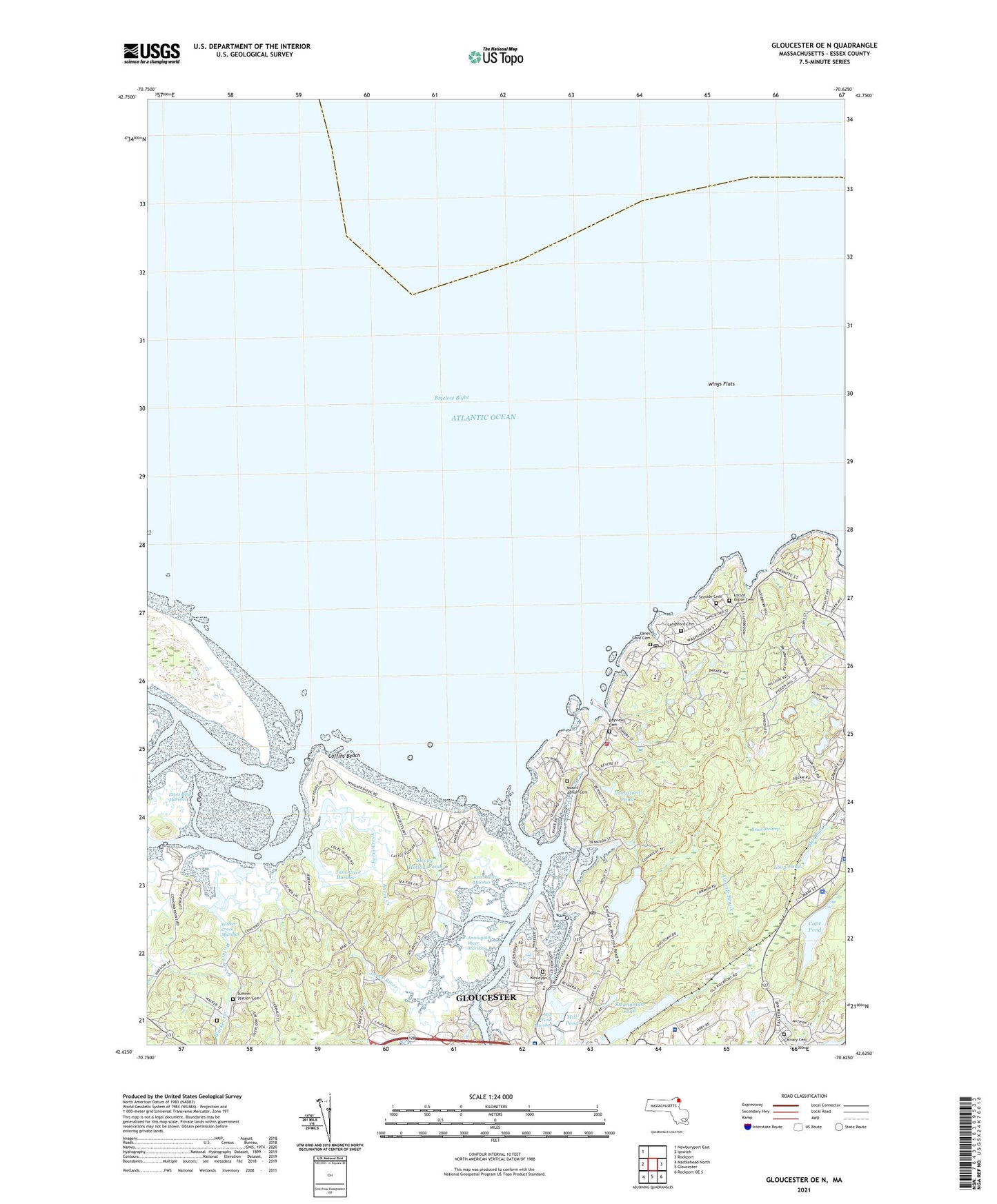
2024 topographic map quadrangle Gloucester OE N in the state of Massachusetts. Scale: 1:24000. Based on the newly updated USGS 7.5' US Topo map series, this map is in the following counties: Essex. The map contains contour data, water features, and other items you are used to seeing on USGS maps, but also has updated roads and other features. This is the next generation of topographic maps. Printed on high-quality waterproof paper with UV fade-resistant inks.
Quads adjacent to this one:
West: Ipswich
Northwest: Newburyport East
East: Rockport
Southeast: Rockport OE S
South: Gloucester
Southwest: Marblehead North
Contains the following named places: A. Piatt Andrew Bridge, Addison Gilbert Hospital-Northeast Hospital Corporation Northeast Health Corporation, Alewife Brook, Annisquam, Annisquam Exchange and Art Gallery, Annisquam Harbor, Annisquam Harbor Light, Annisquam Historical Society Building, Annisquam Lighthouse, Annisquam River, Annisquam River Marshes, Annisquam Village Church, Babson Point, Babson Reservoir, Babson Reservoir Dam, Bald Rocks, Barn Rocks, Bay State Quarry, Bay View, Bayview Cemetery, Beauport Ambulance Service, Beeman Memorial School, Black Rock, Blackburn Industrial Park, Boynton Island, Briar Swamp, Calvary Cemetery, Cape Ann Bible Church, Cape Pond, Castle Neck River, Choate Island Channel, City of Gloucester, Coffins Beach, Coles Island, Conomo Point, Cross Island, Davis Neck, Dilly Island, Dogtown Commons, Dolliver Cemetery, Essex Bay, Essex Bay Marshes, Essex River, Evans Field, Faith Christian School, Farm Creek, Farm Creek Marshes, Farm Point, Ferry Hill, Folly Cove, Folly Point, Gannerys Quarry, Gloucester Fire Department Bay View Station, Goose Cove, Goose Cove North Dam, Goose Cove Northwest Dike, Goose Cove South Dam, Goose Cove Southwest Dike, Great Hill, Halibut Point, Halibut Point Reservation, Hodgkins Cove, Ipswich Bay, James L Babson Museum, Jones River, Jones River Marshes, Lanes Cove, Lanes Cove Cemetery, Lanes Creek, Lanesville, Lanesville Congregational Church, Lanesville Post Office, Langsford Cemetery, Langsford Pond, Lobster Cove, Locust Grove Cemetery, Loop Pond, Mercer School, Mill Pond, Mill Pond Marshes, Mill River, Mill River Culvert and Tide Gate Dam, Montgomery Cove, Mount Adnah Cemetery, North Channel, Nugent Heliport, Oak Island, Paper House, Pearce Island, Pigeon Cove, Pigeon Cove School, Pigeon Hill, Plum Cove, Plum Cove School, Pond Road Heliport, Pool Hill, Quarry Reservoir Dam, Railcut Hill, Ralph B Omaley Middle School, Ram Island, Riverdale, Riverdale Post Office, Riverdale Station, Riverview, Riverview Landing, Rockport Police Department, Rockport Station, Rowley Shore, Rust Island, Seaside Cemetery, Sleepy Hollow Pond, Strangman Pond, Strangman Pond Dam, Sumner Station Cemetery, Sunset Hill, Thompson Mountain, Thurston Point, Tommy Island, Twopenny Loaf, University of Massachusetts Marine Station, Walker Creek, Walker Creek Marshes, Wesleyan Cemetery, West Parish, Wheeler Point, Wigwam Point, Wingaersheek, Wingaersheek Beach, Wings Flats, YMCA Camp