MyTopo
Marlborough Massachusetts US Topo Map
Couldn't load pickup availability
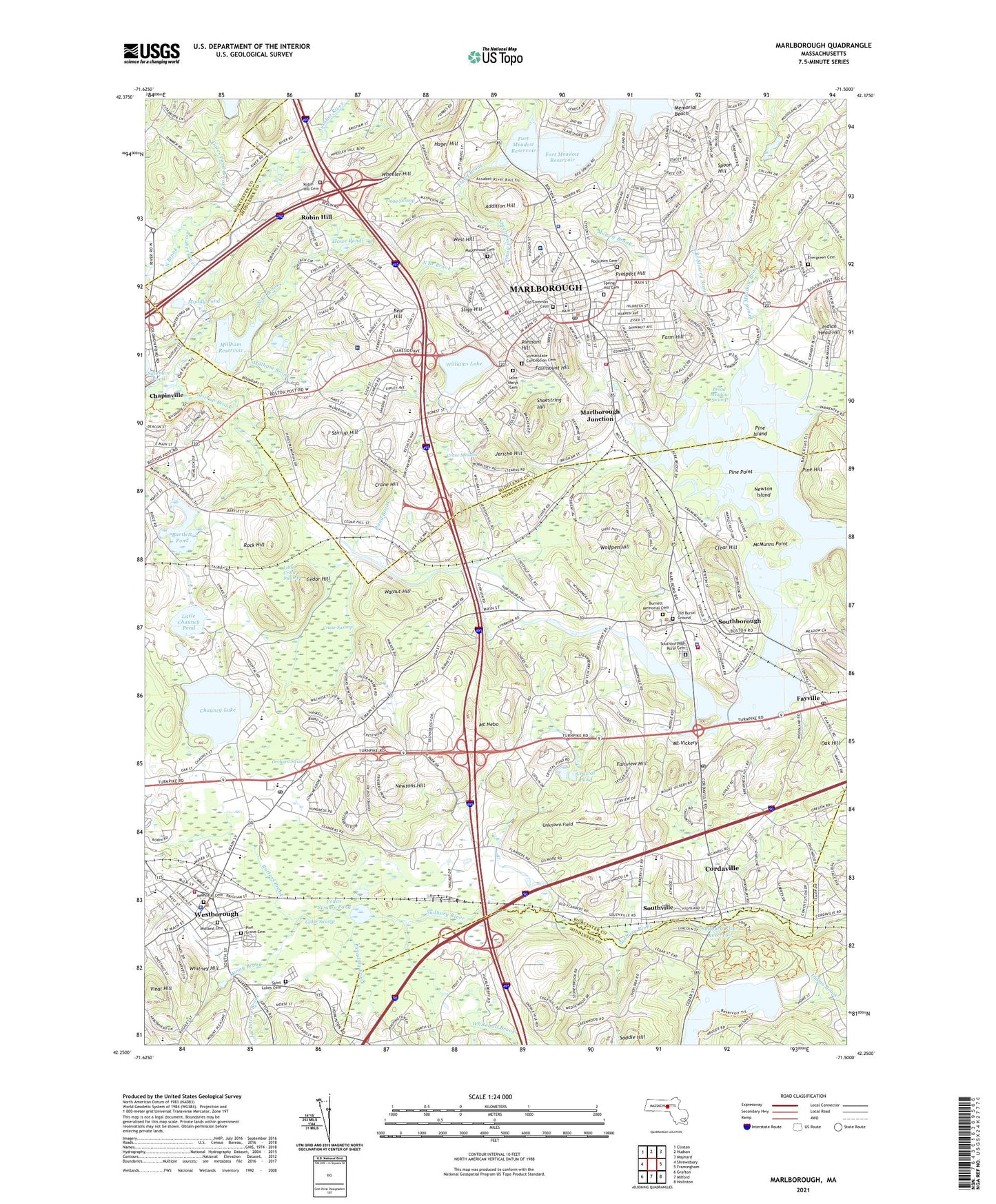
2021 topographic map quadrangle Marlborough in the state of Massachusetts. Scale: 1:24000. Based on the newly updated USGS 7.5' US Topo map series, this map is in the following counties: Worcester, Middlesex. The map contains contour data, water features, and other items you are used to seeing on USGS maps, but also has updated roads and other features. This is the next generation of topographic maps. Printed on high-quality waterproof paper with UV fade-resistant inks.
Quads adjacent to this one:
West: Shrewsbury
Northwest: Clinton
North: Hudson
Northeast: Maynard
East: Framingham
Southeast: Holliston
South: Milford
Southwest: Grafton
Contains the following named places: Addition Hill, Algonquin Regional High School, Algonquin Regional High School Library Media Center, Annie E Fales School, Assabet Valley Collaborative School, Assemblia De Deus De Marlboro, Barefoot Brook, Bartlett Pond, Bartlett Pond Dam, Bear Hill, Bigelow Elementary School, Borough Shopping Center, Boroughs Shopping Plaza, Boston Park West Industrial Park, Brigham Pond, Broad Meadow Brook, Broad Meadow Swamp, Calvary Chapel Middlesex, Carriage House, Cedar Hill, Cedar Swamp, Cedar Swamp Pond, Central-West District School, Channing School, Chapinville, Chauncy Lake, City of Marlborough, Clear Hill, Colonial Shopping Center, Concord Street Park, Cordaville, Cordaville Census Designated Place, Crane Hill, Crane Meadow, Crane Swamp, Crystal Pond, Denny Brook, Digital - Marlboro Heliport, Elsie A Hastings Elementary School, Evangelical Congregational Church, Evangelized Brazilian Church, Evergreen Cemetery, Factory Town USA Shopping Center, Fairmount Hill, Fairview Hill, Farm Hill, Fay School, Fayville, Fayville Post Office, Finn School, First Baptist Church of Westboro, First Church Congregational, First Church of Christ Scientist, First United Methodist Church, Flagg Brook, Flagg Swamp, Forbes School, Fort Meadow Playground, Fort Meadow Reservoir, Francis J Kane Elementary School, Gates Pond Brook, Glenhaven Academy - JRI School, Grace Baptist Church, Greater Grace Christian Church, Hager Hill, Harvey School, Hildreth Elementary School, Hillside School, Holy Trinity Episcopal Church, Hopkinton Reservoir, Hopkinton Reservoir Dam, Hopkinton State Park, Hopkinton State Park Swimming Pool Dam, Hopkinton State Park Swimming Pool Reservoir, Howe Playground, Howe Pond, Iandolis Shopping Center, Immaculate Conception Cemetery, Immaculate Conception Church, Indian Head Hill, Indian Head Shopping Center, Indian Head Shopping Mall, Intermediate Elementary School, J Harding Armstrong School, Jackstraw Brook, Jericho Hill, Jericho Hill Ski Slope, Julios Shopping Center, Kallander Field, Korean Veterans Field, L'Abri Fellowship Church, Little Chauncy Pond, Little Crane Swamp, Madonna Hall for Girls, Maplewood Cemetery, Margaret A Neary School, Marlboro Airport, Marlborough, Marlborough City Hall, Marlborough Country Club, Marlborough Fire Station, Marlborough Fire Station 2, Marlborough High School, Marlborough Hospital, Marlborough Hospital Heliport, Marlborough Industrial Park, Marlborough Junction, Marlborough Junior High School, Marlborough Middle School, Marlborough Middle School Library, Marlborough Police Department, Marlborough Post Office, Marlborough Public Library, Mary Finn Elementary School Library, McMunns Point, Memorial Beach, Memorial Cemetery, Midland Cemetery, Millham Brook, Millham Reservoir, Millham Water Treatment Plant, Mitchell School, Mount Nebo, Mount Vickery, Mowry Brook, Muddy Pond, Navin Park, New Covenant Christian School, New Life Fellowship Nazarene Church, Newton Island, Newtons Hill, North Branch Brook, North Branch Mowry Brook, North Brook, Northboro Kingdom Hall of Jehovahs Witnesses Church, Oak Hill, Old Common Cemetery, Orchard Swamp, P Brent Trottier School, Piccadilly Brook, Pilgrim Congregational Church, Pine Grove Cemetery, Pine Hill, Pine Island, Pine Point, Pine Tree County School, Pleasant Hill, Post Road Shopping Center, Prospect Hill, Richer Elementary School, Road Brook, Robin Hill, Robin Hill Cemetery, Rock Hill, Rocklawn Cemetery, Route 20 Shopping Center, Rutters Brook, Saddle Hill, Saint Anne Church, Saint Anne Convent, Saint Anns School, Saint Lukes Cemetery, Saint Lukes Church, Saint Marks Episcopal Church, Saint Marks School, Saint Marys Cemetery, Saint Marys Church, Sargeant Charles J Jaworek School, Sheep Fall Brook, Shoestring Hill, Simpson Playground, Sligo Hill, South Union School, Southborough, Southborough Fire Department, Southborough Police Department, Southborough Post Office, Southborough School, Southborough Station, Southville, Spoon Hill, Spring Hill Cemetery, Stirrup Brook, Stirrup Hill, Sudbury Reservoir, Sudbury River Dam, Sudbury River Reservoir, Temple Building, The Church of Jesus Christ of Latter Day Saints, Town of Southborough, Town of Westborough, Unknown Field, Vinal Hill, Walnut Hill, Ward Park, Washington School, Wayside Union Academy, West Hill, West Main Street Historic District, West Village, Westboro Shopping Center, Westboro Shopping Plaza, Westborough, Westborough Business Park, Westborough Census Designated Place, Westborough Executive Park, Westborough Fire Department, Westborough High School, Westborough High School Media Center, Westborough Office Park, Westborough Police Department, Westborough Post Office, Westborough Public Library, Westborough State Hospital, Westborough Technical Park, Westborough Town Hall, Westerly Water Pollution Control Facility, Westgorough High School, Westmeadow Plaza Shopping Center, Wheeler Hill, Whitehall Brook, Whitney Hill, Whitney School, Whittier Rehabilitation Hospital-Westborough, Wilfred T Hood Medical Library, Williams Lake, Williams Lake Dam, Williams Street Field, Wolfpen Hill, Woodward School, Wormid Airport, WSRO-AM (Marlborough), ZIP Codes: 01581, 01752, 01772