MyTopo
Reading Massachusetts US Topo Map
Couldn't load pickup availability
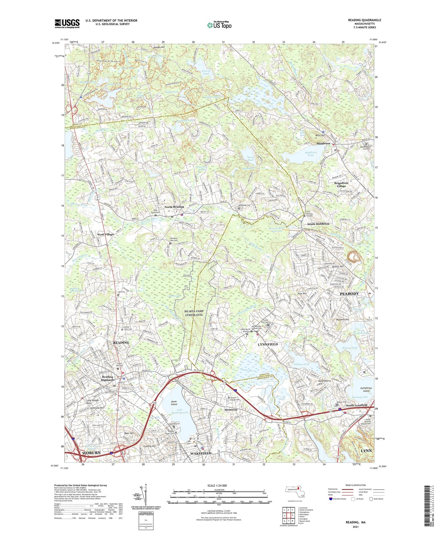
2021 topographic map quadrangle Reading in the state of Massachusetts. Scale: 1:24000. Based on the newly updated USGS 7.5' US Topo map series, this map is in the following counties: Essex, Middlesex. The map contains contour data, water features, and other items you are used to seeing on USGS maps, but also has updated roads and other features. This is the next generation of topographic maps. Printed on high-quality waterproof paper with UV fade-resistant inks.
Quads adjacent to this one:
West: Wilmington
Northwest: Lawrence
North: South Groveland
Northeast: Georgetown
East: Salem
Southeast: Lynn
South: Boston North
Southwest: Lexington
Contains the following named places: A M Barrows School Library, Alice M Barrows School, Arthur W Coolidge Middle School, Aslebe Hill, Atlantic Plaza, Atwell Galvin School, Aunt Betts Pond, Bear Hill, Bear Hill Golf Club, Bear Meadow Brook, Bear Pond, Beaverdam Brook, Benevento Memorial Field, Berry Pond, Birch Meadow School, Boston Brook Dam, Brackett Pond, Brackett Pond Dam, Bradford Pond, Brigadoon Village, Calvary Temple, Camp Curtis Guild National Guard Reservation, Cedar Swamp, Center Depot, Centre Congregational Church, Church-Lafayette Streets Historic District, Collins Pond, Colonial Golf and Country Club, Common District, Common Historic District, Cowdry Hill, Curtis Pond, Devils Dishfull Pond, Devils Dishfull Pond Dam, Dolbeare School, E Ethel Little School, Elginwood Pond, Elginwood Pond Dam, Emerson Brook Lake Street Dam, Emerson Brook Reservoir, Emmanuel Parish Church of Wakefield, Estey Tavern, Field Pond, Field Pond Dam, First Parish Congregational Church, Flint Brook, Flint Burying Ground, Flint Memorial Library, Flint Public Library, Forest Glade Cemetery, Forest Glen Cemetery, Forest Hill Cemetery, Frye Pond, Fuller Meadow School, Grand City Plaza, Harmony Vale Cemetery, Hawkes Pond, Hawkes Pond Outlet Dam, Highland School, Hill View Country Club, Hillview Country Club, Hope Alliance Church, Howe Manning School, Huckleberry Hill, Huckleberry Hill School, Humphreys Island, Hundred Acre Meadow, Hurd School, Ipswich River Dam, Ipswich River Reservoir, J Turner Hood School, J Warren Killam School, John E Burke School, John E McCarthy School, Joshua Eaton School, Kennedy Junior High School, L D Batchelder School, Lake Quannapowitt, Lake Quannapowitt Dam, Lakeside Cemetery, Lakeside Cemetery Chapel, Lakeside Office Park, Laurel Hill Cemetery, Lincoln School, Long Woods Hills, Lorraine Park Campground, Lowell Street School, Lucius Beebe Memorial Library, Lynn Waterways Dam, Lynnfield, Lynnfield Census Designated Place, Lynnfield Center Golf Club, Lynnfield Center School, Lynnfield Fire Department Station 1 Headquarters, Lynnfield Fire Department Station 2, Lynnfield High School, Lynnfield Middle School, Lynnfield Police Department, Lynnfield Post Office, Lynnfield South School, Lynnfield Station, Martins Brook, Martins Pond Dam, Massachusetts State Police Station A1 Andover Barracks, Middleton, Middleton Fire Department Station 1 Headquarters, Middleton Historical Society Library, Middleton Police Department, Middleton Pond, Middleton Pond Outlet Dam, Middleton Post Office, Mill Meadow, Mill Pond, Monk Island, Montrose, Montrose School, Murphy School, North Reading, North Reading Fire Department, North Reading High School, North Reading Junior High School, North Reading Middle School, North Reading Police Department, North Reading Post Office, Oakdale Cemetery, Odyssey Day School, Old Cemetery, Our Lady of the Assumption School, Park Street Cemetery, Parker Tavern, Pearl Street School, Pillings Pond, Pillings Pond Dam, Pine Hill, Post Office Square Shopping Center, Prospect School, Puritan Lawn Memorial Park Cemetery and Crematory, Rapers Brook, Reading, Reading Census Designated Place, Reading Fire Department Headquarters, Reading Fire Department Station 2, Reading High School, Reading Highlands, Reading Police Department, Reading Post Office, Reading Public Library, Reading Town Hall, Reading Townhall, Richardsons Pond, Riverside Cemetery, Sagamore Springs Golf Club, Saint Agnes School, Saint Josephs School, Salem Pond, Scotland Hill, SEEM Collaborative School, Skug River, South Lynnfield, South Lynnfield Post Office, South Middleton, South Reading Academy, Stearns Pond, Stearns Pond East Dam, Strawberry Meadow, Sudden Pond, Sullivan Memorial Park, Summer Street School, Summer Street School Library, Suntaug Lake, Suntaug Lake Dam, Swan Pond, Temple Israel Cemetery, The Thomson Country Club, Town of Lynnfield, Town of Middleton, Town of North Reading, Town of Reading, Town of Wakefield, Union Church, Uptons Hill, Veterans Field, Wakefield, Wakefield Census Designated Place, Wakefield Fire Department Station 1 Headquarters, Wakefield Industrial Center, Wakefield Park, Wakefield Police Department, Wakefield Post Office, Wakefield Town Hall, Wakefield Townhall, Wakefield-Lynnfield United Church, Waldens Hill, Walnut Street School, Walter S Parker Middle School, Walton School, WCGY-FM (Lawrence), West Memorial School, West Peabody Post Office, West Village, West Ward School, Willow Cemetery, Wills Brook, Wills Hill, Winona Pond, Winona Pond Dam, Woburn Street Historic District, Yale Avenue Historic District, YMCA, ZIP Codes: 01864, 01867, 01880, 01940, 01949