MyTopo
Lawrence Massachusetts US Topo Map
Couldn't load pickup availability
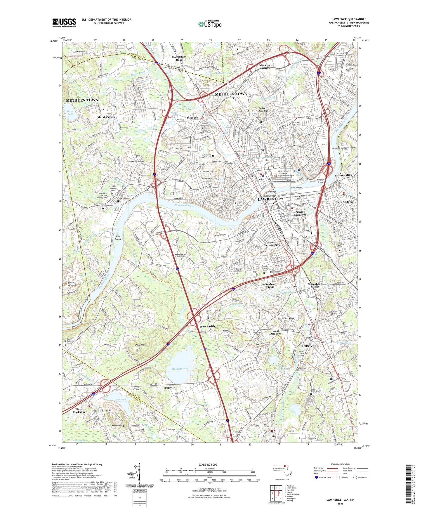
2024 topographic map quadrangle Lawrence in the states of Massachusetts, New Hampshire. Scale: 1:24000. Based on the newly updated USGS 7.5' US Topo map series, this map is in the following counties: Essex, Middlesex, Rockingham, Hillsborough. The map contains contour data, water features, and other items you are used to seeing on USGS maps, but also has updated roads and other features. This is the next generation of topographic maps. Printed on high-quality waterproof paper with UV fade-resistant inks.
Quads adjacent to this one:
West: Lowell
Northwest: Windham
North: Salem Depot
Northeast: Haverhill
East: South Groveland
Southeast: Reading
South: Wilmington
Southwest: Billerica
Contains the following named places: Abbot Academy, Alexander B Bruce School, American Woolen Mill Housing District, Ames Hill, Ames Pond, Ames Pond Dam, Ames Pond Industrial Park, Andover, Andover Census Designated Place, Andover Central School, Andover Country Club, Andover High School, Andover Junior High School, Andover Station, Andover West Middle School, Annie L Sargent School, Arlington School, Arlington-Basswood Historic District, Ashford Street School, Assumption School, Baker Meadow Reservation, Bakers Meadow Pond, Bakers Meadow Reservoir, Bakers Meadow Reservoir Dam, Ballard Pond, Ballardvale, Ballardville Station, Bancroft Elementary School, Bartlett Brook, Bellevue Cemetery, Bloody Brook, Bon Secours Hospital, Bradstreet School, Breen School, Brothers of Sacred Heart Dam, Burke Memorial Hospital, Caldor Shopping Center, Campagnone Common, Carmel Hill, Casey Bridge, Central Catholic High School, Central Elementary School, Charles S Storrow School, City of Lawrence, City of Methuen Town, Clover Hill Hospital, Cochichewick River, Community Day School, Corliss Schools, Costello Park, Coyne Park, Cronin Playground, Currier School, Daddy Frye Hill, Deer Jump Reservation, Den Rock Park, Digital - Dascomb Road Heliport, Digital Heliport, Digital Minuteman Heliport, Downtown Lawrence Historic District, Duck Bridge, Elmwood Cemetery, Emily G Wetherbee School, Essex County Training School, Essex Plaza Shopping Center, Fish Brook, Flemings School, Forest Lake, Forest School, Foss School, Great Swamp, Greater Lawrence Regional Vocational Technical School, Griffin Brook, Haggetts, Haggetts Pond, Haggetts Pond Dam, Hampshire Road, Harold R Rafton Reservation, Harris Brook, Hawkes Brook, Henry C Sanborn Elementary School, Henry K Oliver School, Hickory Hill Golf Course, High Plain Reservation, Hills Pond, Holy Family Hospital - Metheun, Holy Family Hospital Heliport, Holy Rosary School, Holy Sepulchre Cemetery, Holy Trinity School, Howard Playstead, Hussey Brook, Hussey Pond, Immaculate Conception Cemetery, Indian Ridge, Indian Ridge Golf Club, Indian Ridge Reservation, Jackson School, Jackson Terrace Historic District, James F Leonard School, John R Rollins School, Kane School, Kendall Cemetery, L F Dewing School, Lawlor School, Lawrence, Lawrence Central High School, Lawrence General Hospital, Lawrence General Hospital Heliport, Lawrence High School, Lawrence Junior High School, Lawrence Reservoir, Lawrence Reservoir Dam, Lithuanian National Catholic Cemetery, Machine Shop Station, Mann Orchards, Marsh Corner, Marston Corners, Meetinghouse Hill, Memorial Park, Merrimac Plaza, Merrimack College, Merrimack River Dam, Merrimack River Reservoir, Merrimack Valley Seaplane Base, Methnen Central School, Methuen, Methuen Mall, Mill Pond, Mount Carmel School, Mount Vernon Park, Mullaney Park, Mystic Pond, Nickel Mine Hill, North Andover, North Andover Mall, North Andover Plaza, North Canal, North Canal Outlet Dam, North Canal Reservoir, North Tewksbury, Oakland School, O'Connell Park, O'Leary Bridge, O'Reilly Bridge, Osgood Pond, Peat Meadow, Philips Academy Isham Health Center, Phillips Academy, Pie Hill, Pike School, Pine Island, Pinnacle Hill, Pleasant Valley School, Policy Brook, Polish Cemetery, Prospect Hill, Rabbit Pond, Riley Playground, Rogers Brook, Sacred Heart Cemetery, Sacred Heart Elementary School, Saint Annes School, Saint Anthonys Cemetery, Saint Augustine Cemetery, Saint Augustines School, Saint Basils Seminary, Saint Francis Cemetery, Saint Francis School, Saint Lawrence School, Saint Marys Cemetery, Saint Michael Elementary School, Saint Monica Elementary School, Saint Patrick Elementary School, Saint Ritas School, Saints Peter and Paul Cemetery, Saunders School, Sawyer Brook, Searles Cemetery, Searles Pond, Searles Pond Dam, Searles School, Shawnsheen Park, Shawnsheen River Reservation, Shawsheen Heights, Shawsheen Plaza, Shawsheen River, Shawsheen River Dam, Shawsheen River Reservoir, Shawsheen Village, Sons of Israel Cemetery, South Canal, South Elementary School, South Lawrence, South Lawrence Plaza, Spicket River, Spicket River at Lowell Street Dam, Spicket River Reservoir, Spree Shopping Center, Spring Grove Cemetery, Starrow Park, Stephen Barker School, Stevens Pond, Stevens Pond Outlet Dam, Stowe School, Sutton Pond, Suttons Mills, Syrian Cemetery, Tabox School, Temple Emanuel Cemetery, Tenney High School, Thomson School, Tower Hill, Town of Andover, Townsend Pond, Vale Reservation, Walnut Grove Cemetery, WCCM-AM (Lawrence), WCGY-FM (Lawrence), West Andover, West Andover High School, West Elementary School, West Parish, West Parish Cemetery, West School, WLLH-AM (Lawrence), Wood Hill, World End Brook, WPAA-FM (Andover), WSSH-FM (Lowell), ZIP Codes: 01810, 01840, 01841, 01843, 01844