MyTopo
Salem Massachusetts US Topo Map
Couldn't load pickup availability
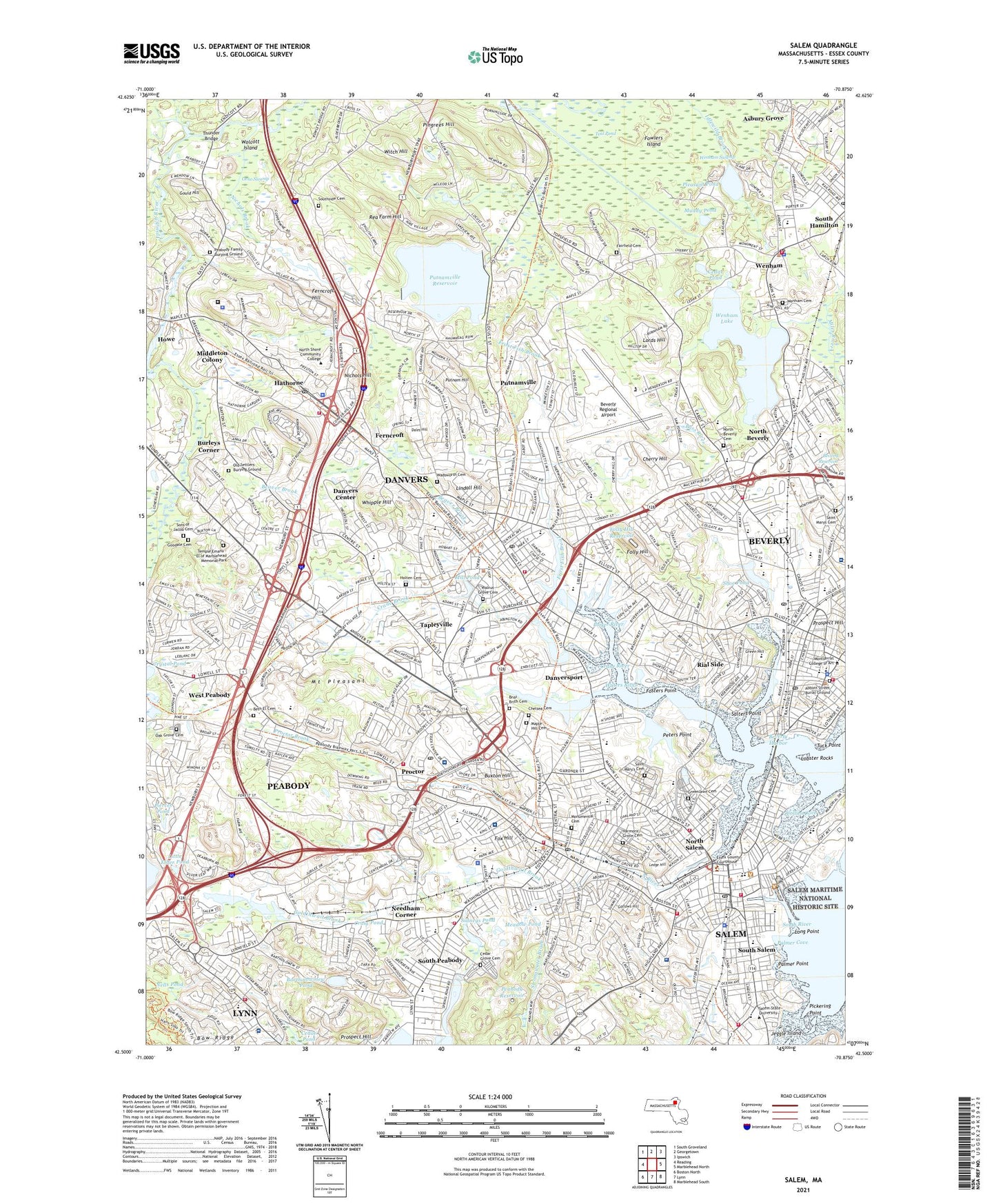
2024 topographic map quadrangle Salem in the state of Massachusetts. Scale: 1:24000. Based on the newly updated USGS 7.5' US Topo map series, this map is in the following counties: Essex. The map contains contour data, water features, and other items you are used to seeing on USGS maps, but also has updated roads and other features. This is the next generation of topographic maps. Printed on high-quality waterproof paper with UV fade-resistant inks.
Quads adjacent to this one:
West: Reading
Northwest: South Groveland
North: Georgetown
Northeast: Ipswich
East: Marblehead North
Southeast: Marblehead South
South: Lynn
Southwest: Boston North
This map covers the same area as the classic USGS quad with code k42070e7.
Contains the following named places: Abbott Street Burial Ground, Alfalfa Farm, Asbury Grove, Asylum Station, Balch Playground, Bartholowmew Pond, Bass River, Bates Park, Beaver Brook, Beaver Brook Station, Bertram Field, Bessie Baker Park, Beth El Cemetery, Beverly, Beverly Center Business District, Beverly Depot, Beverly Depot Station, Beverly Golf and Tennis Club, Beverly Harbor, Beverly Hospital, Beverly Hospital Heliport, Beverly Plaza, Beverly Regional Airport, Beverly Reservoir, Beverly Reservoir Dam, Bnai Brith Cemetery, Boston Brook, Bow Ridge, Brooksby Farm, Browns Pond Dam, Burleys Corner, Buxton Hill, Cabot Street Shopping Center, Cabot Street Shopping Center / Professional Building, Cedar Brook, Cedar Grove Cemetery, Cedar Pond, Charter Street Historic District, Chelsea Cemetery, Cherry Hill, Chestnut Street District, City of Peabody, City of Salem, Collins Cove, Craig Pond, Crane Brook, Crane River, Crombie Street District, Crowninshield-Bentley House, Crystal Pond, Cummings Park, Dales Hill, Danvers, Danvers Census Designated Place, Danvers Center, Danvers Park, Danvers Plaza, Danvers Plaza Shopping Center, Danvers Port Station, Danvers Reservoir, Danvers State Hospital, Danversport, Derby Waterfront District, Derby Wharf, Derby Wharf Light, Downtown Salem District, East India Mall Shopping Center, East India Square Fountain, Elliot Street Shopping Plaza, Elliott Street Shopping Plaza Shopping Center, Endicott Plaza, Endicott Plaza Shopping Center, Endicott Square, Endicott Square Shopping Center, Essex Institute Historic District, Essex Street Mall, Federal Street District, Femino Park, Ferncroft, Ferncroft Hill, Ferncroft Village Heliport, Fish Flake Hill Historic District, Folly Hill, Folly Hill Reservoir, Forest River Park, Fosters Point, Fountain Pond Dam, Fowlers Island, Fox Hill, Frost Fish Brook, Gallows Hill, Gallows Hill Park, Goldthwait Brook, Goodale Cemetery, Gould Hill, Gowdy Playground, Green Hill, Greenlawn Cemetery, Harmony Grove Cemetery, Hatchs Wharf, Hathorne, Hawthorne Birthplace, Hawthorne Cove Marina, Hawthorne Square Mall, Hawthorne Square Mall Shopping Center, Herling Park, Highland Park, Highland Plaza, Highlander Plaza Shopping Center, Holten Cemetery, Hospital Point Rear Range Light, House of Seven Gables Historic District, Howe, Hunt Memorial Hospital, Independence Park, Innocenti Park, Jeggle Island, Kernwood Golf Course, Kernwood Park, Kindred Hospital Boston North Shore, Kings Plaza, Kings Pool, Lahey Medical Center Peabody, Ledge Hill, Liberty Tree Mall, Lindall Hill, Little Elder Pond, Lobster Rocks, Long Point, Lords Hill, Maple Hill Cemetery, Meadow Pond, Middleton Colony, Mill Pond, Mill Pond Dam, Monumental Cemetery, Mount Pleasant, Muddy Pond, Needham Corner, Nells Pond, Newhall Station, Nichols Brook, Nichols Hill, Norris Brook, North Beverly, North Beverly Cemetery, North Beverly Station, North River, North Salem, North Shore Children's Hospital, North Shore Medical Center Salem Hospital, North Shore Medical Center Union Hospital, North Shore Shopping Center, Oak Grove Cemetery, Obear Park, Old Settlers Burying Ground, Orne Swamp, Palmer Cove, Palmer Point, Peabody, Peabody Family Burying Ground, Peabody Reservoir, Peters Point, Pickering Point, Pickering Wharf, Pierces Pond, Pingree Park, Pingrees Hill, Pleasant Pond, Porter River, Primrose Shopping Center, Proctor, Proctor Brook, Proctors Station, Prospect Hill, Puritan Lawn Memorial Park, Putnam Hill, Putnamville, Putnamville Reservoir, Putnamville Reservoir Dam, Putnamville Reservoir East Dike, Putnamville Reservoir West Dike, Rea Farm Hill, Rial Side, Ross Memorial Park, Saint Marys Cemetery, Saint Mary's Cemetery, Salem, Salem Common, Salem Country Club, Salem Harbor, Salem Maritime National Historic Site, Salem Reservoir, Salem Reservoir Dam, Salem Station, Salters Point, Shoe Pond, Shoe Pond Dam, Sidneys Pond, Sons of Jacob Cemetery, South Hamilton, South Peabody, South River, South Salem, Southside Cemetery, Spring Pond, Spring Pond Dam, Strongwater Brook, Sydneys Pond, Sydneys Pond Dam, Tapley Brook, Tapleyville, Tapleyville Station, Temple Emanu - El of Marblehead Memorial Park, Thunder Bridge, Town of Danvers, Town of Wenham, Tuck Point, Wadsworth Cemetery, Walnut Grove Cemetery, Waters River, Wenham, Wenham Cemetery, Wenham Lake, Wenham Swamp, West Peabody, Whipple Hill, Witch Hill, WMWM-FM (Salem), WNSH-AM (Beverly), Wolcott Island, ZIP Codes: 01923, 01937, 01960, 01984