MyTopo
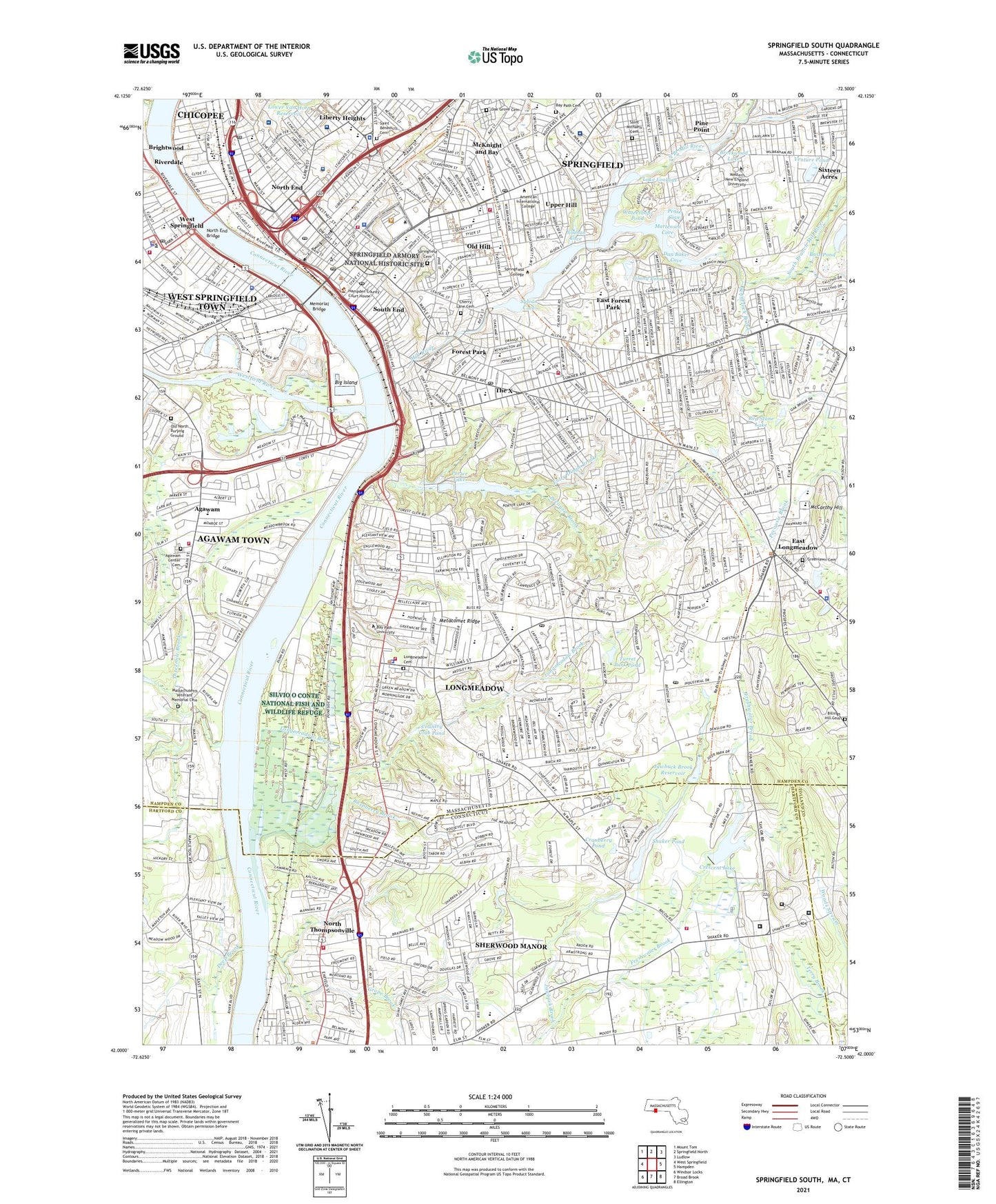
Springfield South Massachusetts US Topo Map
Couldn't load pickup availability
2021 topographic map quadrangle Springfield South in the states of Massachusetts, Connecticut. Scale: 1:24000. Based on the newly updated USGS 7.5' US Topo map series, this map is in the following counties: Hampden, Hartford, Tolland. The map contains contour data, water features, and other items you are used to seeing on USGS maps, but also has updated roads and other features. This is the next generation of topographic maps. Printed on high-quality waterproof paper with UV fade-resistant inks.
Quads adjacent to this one:
West: West Springfield
Northwest: Mount Tom
North: Springfield North
Northeast: Ludlow
East: Hampden
Southeast: Ellington
South: Broad Brook
Southwest: Windsor Locks
Contains the following named places: Agawam, Agawam Center Cemetery, Agawam-Springfield Seaplane Harbor Base, Alfred M Glickman Elementary School, Allen Street Shopping Center, Ames Hill-Crescent Hill Historic District, Apremont Triangle Historic District, Armory Square, Armory Street Park, Arthur T Talmadge School, Bagg Brook, Barrows Playground, Bass Pond, Bay Path Cemetery, Bay Path College, Baystate Medical Center, Baystate Medical Center Heliport, Belle and Franklin Street Historic District, Benedum Field, Benjamin J Phelps School, Berry Field, Big Island, Bill Playground, Birchland Park School, Bliss Park, Borgati Park, Brainerd Park, Breckwood Lake, Breckwood Lake Dam, Breckwood Park, Breckwood Shopping Center, Bridge Academy/Martin Luther King Academy, Brightwood, Calhoun Park, Center Square, Center Square Shopping Center, Century Shopping Center, Cherry Lane Cemetery, City of Springfield, Cohen Park, Cooley Brook, Country Club Pond, Court Square, Court Square Historic District, Cranberry Pond, Crescent Grove, Crescent Lake, Crescent Lake Dam, Cybulski Industrial Park, Dan Baker Cove, Deep Brook, Downtown Springfield Railroad District, Dunbar Shopping Center, East Forest Park, East Longmeadow, East Longmeadow Industrial Park, East Park, Eastern States Exposition Grounds, Elias Brookings K-8 Magnet School, Emily Bill Playground, Entry Dingle Brook, Entry Dingle Park, Fannie Stebbins Wildlife Refuge, Federal Square, Field Club of Longmeadow, Five Town Plaza, Five Town Plaza Shopping Center, Forest Park, Forest Park Upper Dam, Fourmile Brook, Franconia Golf Course, Frederick Harris School, Garden Plaza, Garden Plaza Shopping Center, Gateway Shopping Center, George M Hendee Playground, Grape Brook, Greenwood Park, Gunn Square, Gurdon Bill Park, Heritage Park, Heritage Park Plaza, Heritage Park Plaza Shopping Center, Holy Cross School, Holy Family School, Holy Name School, Island Pond, Island Pond Road Shopping Center, J L Sullivan Playground, Jawbuck Brook, Jawbuck Brook Reservoir, John J Duggan Middle School, Lafayette Park, Lake Lookout, Lake Lookout Dam, Laurel Park, Leahy Field, Liberty Heights, Longmeadow, Longmeadow Brook, Longmeadow Cemetery, Longmeadow Census Designated Place, Longmeadow Country Club, Longmeadow Country Club Dam, Longmeadow Historic District, Longmeadow Mall Shopping Center, Longmeadow Plaza, Longmeadow Shops, Longmeadow Shops Shopping Center, Maple Center, Maple Center Shopping Center, Mapleshade School, Martensen Cove, Massachusetts Mutual Heliport, Massachusetts Veterans' Memorial Cemetery, McCarthy Hill, McKnight and Bay, Meadowbrook Park, Memorial Bridge, Memorial Square District, Mercy Medical Center, Merrick, Mill River, Noonan Cove, North Branch Mill River, North Branch Park, North End, North End Bridge, North Main Shopping Center, North Thompsonville, Oak Grove Cemetery, Old Hill, Old North Burying Ground, One-Stop Shopping Center, Osborn Prison Farm, Pease Cove, Pecousic Brook, Pine Point, Piper Brook, Plesant View School, Porter Lake, Potter Field, Putnams Puddle Dam, Pynchon Park, Quadrangle-Mattoon Street Historic District, Raspberry Brook, Red Stone Lake, River Front Park, Riverdale, Riverdale Shops Shopping Center, Riverside Park, Rockys Plaza, Rockys Plaza Shopping Center, Saint Benedicts Cemetery, Saint Michaels Cemetery, Schnelock Brook, School Street School, Shaker Pines, Shaker Pond, Shaker Pond Dam, Shakers Church Farm, Sherwood Manor, Sherwood Manor Census Designated Place, Shriners Hospital for Children - Springfield, Sixteen Acres, South Branch Mill River, South End, Springfield, Springfield Armory National Historic Site, Springfield Cemetery, Springfield College, Springfield High School, Springfield High Schools, Springfield Memorial School, Springfield Museum Quadrangle, Stebbins Park, Sumner Avenue School, Sylvan Cove, Tarkill Brook, Tennessee F Heliport, The Mall at Center Square Shopping Center, The X, Threemile Brook, Town of Longmeadow, Trade School, Trading Post Shopping Center, Triano Industrial Park, Turner Park, Turner Park Dam, Turret Park Pond, Twin Hills Country Club, Upper Hill, Upper Worthington Historic District, Ursuline Academy, Venture Pond, Vibra Hospital, WAIC-FM (Springfield), Walker Playground, Washington School, Watershops Pond, Watershops Pond Dam, Waterworks Brook, Wells Block, Wesson Hospital, Wesson Park, West Springfield, Westfield River, Wetstone Tobacco Company Dam Number 3, Wheel Meadow Brook, Wight Playground, Williams Place Shopping Mall Shopping Center, Williams Street Playground, Winchester Plaza, Winchester Plaza Shopping Center, Winchester Shoppers Plaza Shopping Center, Winchester Shopping Center, Winchester Square, Winchester Square Historic District, WIXY-AM (East Longmeadow), WMAS-AM (Springfield), WMAS-FM (Springfield), WNEK-FM (Springfield), Worthington Brook, WSCB-FM (Springfield), WSPR-AM (Springfield), WTCC-FM (Springfield), ZIP Codes: 01103, 01105, 01106, 01107, 01108, 01109, 01118, 01119, 01199