MyTopo
Broad Brook Connecticut US Topo Map
Couldn't load pickup availability
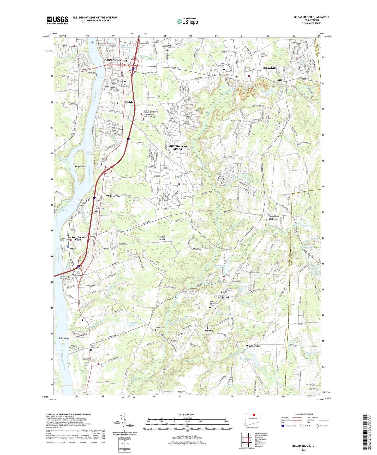
2024 topographic map quadrangle Broad Brook in the state of Connecticut. Scale: 1:24000. Based on the newly updated USGS 7.5' US Topo map series, this map is in the following counties: Hartford, Tolland. The map contains contour data, water features, and other items you are used to seeing on USGS maps, but also has updated roads and other features. This is the next generation of topographic maps. Printed on high-quality waterproof paper with UV fade-resistant inks.
Quads adjacent to this one:
West: Windsor Locks
Northwest: West Springfield
North: Springfield South
Northeast: Hampden
East: Ellington
Southeast: Rockville
South: Manchester
Southwest: Hartford North
This map covers the same area as the classic USGS quad with code o41072h5.
Contains the following named places: Asnuntuck Community College, Asnuntuck Community College Learning Resources Center, Balchs Airpark, Bassdale Plaza Shopping Center, Beemans Brook, Bethany Baptist Church, Blue Ditch, Bootleggers Seaplane Base, Boweyns Brook, Bradleys Brook, Bradleys Pond, Broad Brook, Broad Brook Census Designated Place, Broad Brook Congregational Church, Broad Brook Elementary School, Broad Brook Millpond, Broad Brook Millpond Dam, Broad Brook Post Office, Broad Brook Reservoir, Broad Brook Volunteer Fire Department, Brookside Plaza Shopping Center, Buckhorn Brook, Calvary Presbyterian Church, Central Library, Chesters Shopping Center, Chestnut Brook, Cohoes Common Shopping Center, Connecticut Industrial Business Park, Connecticut River Reservoir, Connecticut State Childrens Home, Connecticut Trolley Museum, Connecticut Trolley Museum Library, Creamery Brook, Creamery Pond, Della Heliport, Dexter Cuffin Junior Bridge, Digital Heliport, Doctor John E Flaherty State Wildlife Area, East Street School, East Windsor Ambulance Association, East Windsor Fire Marshal's Office, East Windsor Historical Society Museum, East Windsor Industrial Park, East Windsor Junior High School, East Windsor Middle School, East Windsor Police Department, East Windsor Post Office, East Windsor Town Park, Edgar H Parkman Elementary School, Edgar H Parkman School, Eli Whitney Elementary School, Elm Plaza Shopping Center, Enfield, Enfield American Baptist Church, Enfield Bridge, Enfield Christian Academy, Enfield Church of Christ, Enfield Community Ambulance, Enfield Dam, Enfield Falls, Enfield Fire Department District 1 Station 1, Enfield Fire Department District 1 Station 2, Enfield Head Start, Enfield High School, Enfield Mall, Enfield Memorial Industrial Park, Enfield Montessori School, Enfield Police Department, Enfield Post Office, Enfield Shopping Plaza, Enfield Shopping Plaza Shopping Center, Enfield Square, Enfield Square Shopping Center, Enfield Street Cemetery, Enfield Street Elementary School, Enfield Street Post Office, Enfield Town Fire Dispatch Center, Enfield Town Meetinghouse, Enrico Fermi High School, Faith Baptist Church, Freshwater Brook, Freshwater Plaza Shopping Center, Freshwater Pond, Freshwater Pond Dam, Grace Episcopal Church, Grassmere Golf Course, Green Manor Pool, Green Manorville Shopping Center, Guild Pond, Harriet Beecher Stowe School, Harrington Brook, Hartfield Industrial Park, Hazardville, Hazardville Census Designated Place, Hazardville Fire Department, Hazardville Historic District, Hazardville Memorial Elementary School, Hazardville Station, Hazardville United Methodist Church, Holy Family Roman Catholic Church, Howell Cheney Satellite Vocational School, John F Kennedy Junior High School, John F Kennedy Middle School, Ketch Brook, King Street Cemetery, Kingdom Hall of Jehovahs Witnesses, Kings Corner, Kings Island, Laurie Field, Library Association of Warehouse Point, Longview Catholic High School, Mark Twain School, Melrose, Mill Pond Village, Mount Zion Church, Namerick Brook, Nathan Hale Elementary School, New Hazardville Cemetery, North End Cemetery, Old Town Hall Historical Society Building, Oliver Ellsworth Homestead, Osborne Pond, Our Redeemer Lutheran Church, Pearl Street Branch Enfield Public Library, Pecks Brook, Peltons Pasture State Board of Fisheries, Pierce Memorial Park, Powder Hollow Park, Powder Mill Ponds, Raffia Shopping Center, Rawlins Brook, Roberts Farm Airport, Rustic Brook, Sadds Mill, Sadds Mill Pond, Saint Adalberts Elementary School, Saint Andrew Episcopal Church, Saint Bernard Roman Catholic Church, Saint Bernards Cemetery, Saint Bernards School, Saint Catherines Cemetery, Saint Catherines Church, Saint Johns Episcopal Church, Saint Josephs School, Saint Marys Episcopal Church, Saint Nicholas Greek Orthodox Church, Saint Patricks Cemetery, Saint Patricks Convent, Saint Patricks Roman Catholic Church, Saltonstall Park, Scantic, Scantic Cemetery, Scantic Church, Scantic River State Park, Scitico, Scitico Dam, Scitico River Reservoir, Skylark Airpark, South School, Southwood Acres, Southwood Acres Census Designated Place, Southwood Shopping Parkade, Southwood Shopping Parkade Shopping Center, Spring Glen Brook, Spring Village, Springdale Cemetery, Stateline Plaza Shopping Center, Stony Brook, Stoughton Brook, Stoughtons Pond, Stowes Pond, Suburban Enfield Mall, Suburban Enfield Mall Shopping Center, Suffield Fire Department Station Number 4, Terry Brook, Thomas G Alcorn Elementary School, Thomas G Alcorn School, Thompson Brook, Thompson Pond, Thompsonville, Thompsonville Census Designated Place, Thompsonville Fire Department District 2, Town of East Windsor, Town of Enfield, Town Street Cemetery, Turks Island, Warehouse Point, Warehouse Point Elementary School, Warehouse Point Fire Department Station 1, Warehouse Point Fire Department Station 238, Warehouse Point Park, Warehouse Point Post Office, Warehouse Point Station, Waterworks Brook, Wesley Methodist Church, Whitney Elementary School, Windsorville, Windsorville Cemetery, Windsorville Pond, Windsorville Pond Dam, ZIP Codes: 06016, 06082, 06088