MyTopo
Windsor Locks Connecticut US Topo Map
Couldn't load pickup availability
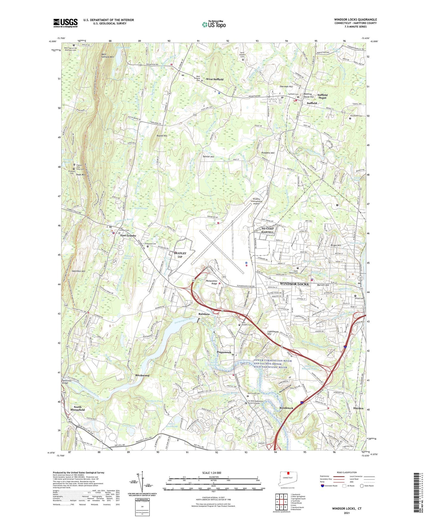
2024 topographic map quadrangle Windsor Locks in the state of Connecticut. Scale: 1:24000. Based on the newly updated USGS 7.5' US Topo map series, this map is in the following counties: Hartford. The map contains contour data, water features, and other items you are used to seeing on USGS maps, but also has updated roads and other features. This is the next generation of topographic maps. Printed on high-quality waterproof paper with UV fade-resistant inks.
Quads adjacent to this one:
West: Tariffville
Northwest: Southwick
North: West Springfield
Northeast: Springfield South
East: Broad Brook
Southeast: Manchester
South: Hartford North
Southwest: Avon
This map covers the same area as the classic USGS quad with code o41072h6.
Contains the following named places: Adds Brook, Airport Center Shopping Center, Airways Golf Course, Allgrove School, Archer Memorial Church, Austin Brook, Barrett Hill, Birchwood, Birges Hill, Boston Neck School, Bradley Field Fire Department Station 1, Bradley Fire Department Station 2, Bradley Industrial Park, Bradley International Airport, Brazin Bruce Park, Breakneck, Bridge Street Elementary School, Bromes Pond, Bull Run Corner, Bungee Lake, Bungee Lake Lower Dam, Cains Pond, Calvary Baptist Church, Calvary Church, Camp Mar-lin, Cannon Pond, Captain John Viets Cemetery, Christian Field, Clay Brook, Clyde Gill Industrial Park, Commission on Fire Prevention and Control Connecticut Fire Academy, Community Church, Connecticut Air National Guard Fire Department, Connecticut State Police Troop H - Bradley International Airport, Copper Hill Golf Course, Creamery Brook, Crown Industrial Park, DeGrayes Brook, Devine Brook, Dexter Plaza Shopping Center, Dibble Hollow Brook, Dismal Swamp, East Granby, East Granby Ambulance Association, East Granby Cemetery, East Granby Congregational Church, East Granby Fire Marshal's Office, East Granby High School, East Granby Historic District, East Granby Middle School, East Granby Police Department, East Granby Post Office, East Granby Public Library, East Granby Town Hall, East Granby Volunteer Fire Department South End Station, East Granby Volunteer Fire Department Station 1, Elm Grove Cemetery, Elmwood Cemetery, Emma Hathaway Branch Library, First Church of Christ, Good Shepherd Lutheran Church, Goodwin Pond, Great Pond, Green Manor Village, Grove Cemetery, Halfmoon Marsh, Hamilton Standard Heliport, Hatchett Hill, Hathaway Hollow, Hathaway House, Hayden, Hazelwood Industrial Park, Hazelwood School, Higley Village, Immanuel Baptist Church, John R Welch Park, Kent Memorial Library, Kettle Brook, Lewis Farm Bird Sanctuary, Lighthouse Hill, Little Brook, Living Waters Fellowship Church, MacDougall - Walker Correctional Institution, Marks Heliport, McAlister Middle School, Meeting House Hill, Memorial Hall, Millpond, Muddy Brook, Mundy Hollow, New England Air Museum, New England Air Museum Research Library, New Life Assembly of God Church, New Life Tabernacle Church, Newgate Pond, Noden-Reed Park, North Bloomfield, North School, North Street School, Northwest Park, Old Newgate Prison, Olds and Whipple Pond, Oliver Ellsworth Elementary School, Our Lady of the Assumption Church, Paper Mill Brook, Peak Mountain, Peski Park, Phelps Brook, Philo Brook, Polish Natl Home, Poquonock, Poquonock Elementary School, Poquonock Post Office, Prisoners Cemetery, Prospect Hill, Rainbow, Rainbow Brook, Rainbow Dam, Rainbow Park, Rainbow Pond, Rainbow Pond Dam, Rattlesnake Brook, Reeds Pond, Rocky Gutter, Round Hill, Sacred Heart Church, Saint Josephs Cemetery, Saint Joseph's Cemetery, Saint Josephs Church, Saint Josephs Convent, Saint Marys Cemetery, Saint Marys Church, Saint Marys School, Saint Robert Bellarmine Church, Sanborn Brook, Schwartz Pond, Schwartz Pond Dam, Second Baptist Church, Seymour Hollow, Sheldens Brook, Sherman Hill, Silver Birch Pond, Soldiers Memorial Hall, South Elementary School, South Street School, Southwest Park, Southwest School, Spaulding School, Spencer Brook, Spoonville, Spoonville Bridge, Spring Dam Pond, Spring Park, Stony Brook Park, Strawberry Meadow Brook, Suffield, Suffield Academy, Suffield Cemetery, Suffield Country Club, Suffield Depot, Suffield Depot Census Designated Place, Suffield Fire Department Station #2, Suffield Fire Department Station Number 1, Suffield Historic District, Suffield Industrial Area, Suffield Middle School, Suffield Post Office, Suffield Pre-Kindergarten, Suffield Senior High School, Suffield Village Shopping Center, Suffield Volunteer Ambulance Association, Taintor Hill, Third Baptist Church, Thralltown, Town of East Granby, Town of Suffield, Town of Suffield Police Department, Town of Windsor Locks, Turnpike Industrial Park, UTC Aerospace Systems Emergency Services Fire Department, West Brook, West Side of the Mountain Cemetery, West Suffield, West Suffield Cemetery, West Suffield Congregational Church, West Suffield Post Office, Whites Pond, Whites Pond Dam, Windsor Congregational Church, Windsor Locks, Windsor Locks Census Designated Place, Windsor Locks Fire Department, Windsor Locks High School, Windsor Locks Lions Ambulance Corps, Windsor Locks Middle School, Windsor Locks Police Department, Windsor Locks Post Office, Windsor Locks Public Library, Windsor Locks Reservoir, Windsor Locks Town Hall, Windsor Volunteer Fire Department Hayden Station, Windsor Volunteer Fire Department Poquonock Station, Windsor-Bloomfield Landfill, Woodlawn Cemetery, Ye Olde Poquonock Burial Grounds, ZIP Codes: 06026, 06078, 06096