MyTopo
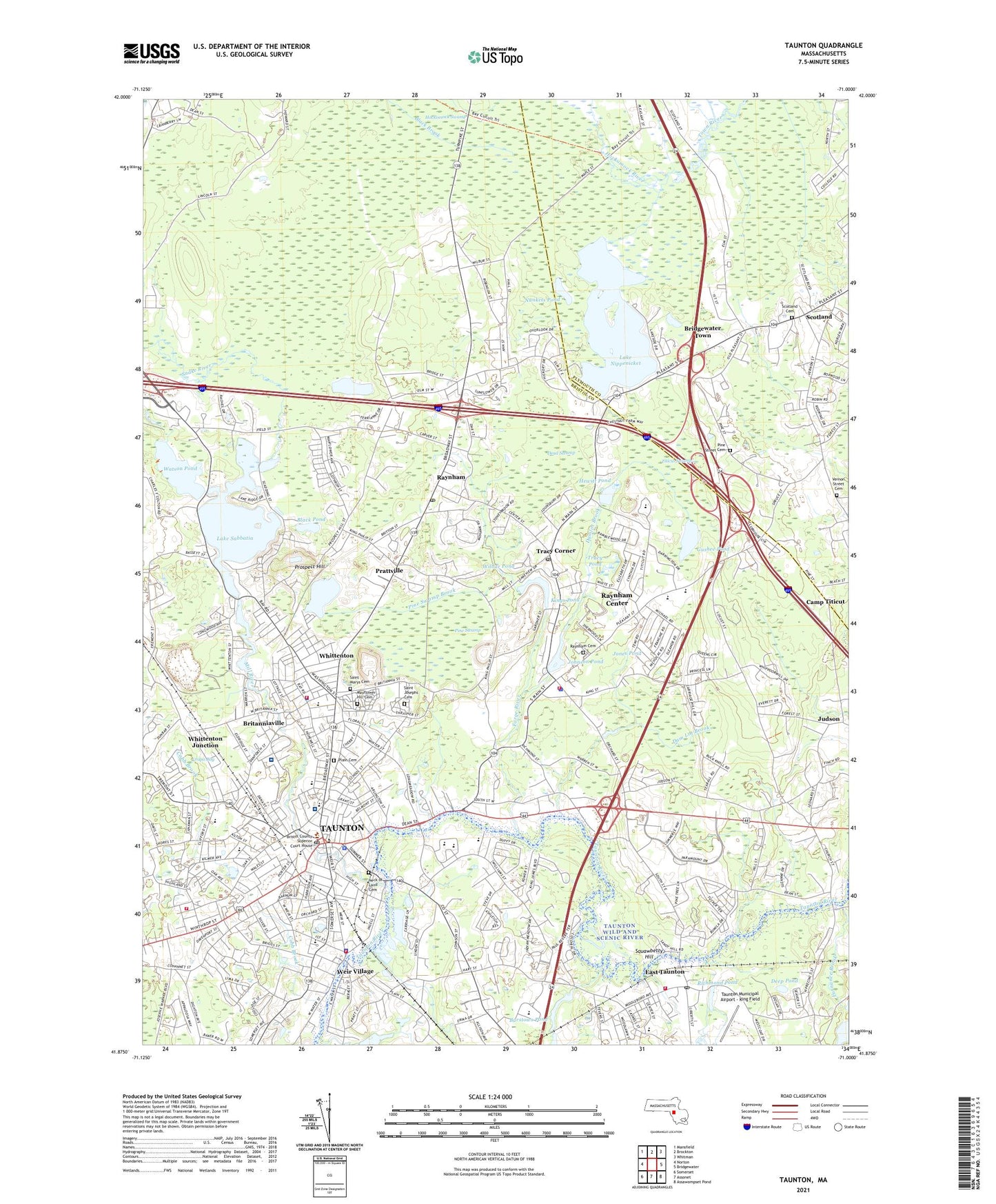
Taunton Massachusetts US Topo Map
Couldn't load pickup availability
2021 topographic map quadrangle Taunton in the state of Massachusetts. Scale: 1:24000. Based on the newly updated USGS 7.5' US Topo map series, this map is in the following counties: Bristol, Plymouth. The map contains contour data, water features, and other items you are used to seeing on USGS maps, but also has updated roads and other features. This is the next generation of topographic maps. Printed on high-quality waterproof paper with UV fade-resistant inks.
Quads adjacent to this one:
West: Norton
Northwest: Mansfield
North: Brockton
Northeast: Whitman
East: Bridgewater
Southeast: Assawompset Pond
South: Assonet
Southwest: Somerset
Contains the following named places: Barstows Pond, Barstows Pond Dam, Bay Colony Shopping Center, Black Brook, Black Pond, Bridgewater Industrial Park, Bristol-Plymouth Regional Technical School Library, Bristol-Plymouth Technical School, Britanniaville, Caleb Barnum School, Cape Road Plaza, Caswell School, City of Taunton, Cobb Brook, Cohannet School, Cotley River, Coyle-Cassidy High School, Crapo Bog, Dam Lot Brook, Damlot Brook, Dead Swamp, Dean Street Station, Deep Pond, East Taunton, East Taunton Post Office, Easton Rod and Gun Club, Ecole Saint Jacques, Elizabeth Pole School, Forge River, Forge River Reservoir, Frank L Tosti Library, Furnance Brook, George H Crosman USAR Center Heliport, Gushee Pond, H H Galligan School, Hewitt Pond, Hockomock River, Hockomock Swamp, Hopewell Elementary School, Hopewell Park, James L Mulcahey School, John F Parker Middle School, Johnson Pond, Johnson Pond Dam, Jones Pond, Joseph H Martin School, Judson, Kings Pond, Kings Pond Dam, Lake Nippenicket, Lake Sabbatia, Laliberte Elementary School, Leonard Elementary School, Lillie B Merrill School, Lowell H Maxham School, Martin Middle School Library Media Center, Maxham School Library Media Center, Mayflower Hill Cemetery, Memorial Park, Mill River, Mill River Dam, Mill River Reservoir, Moreys Bridge Dam, Morton Hospital, Mulcahey Middle School Library Media Center, Neck of Land Cemetery, North School, North Taunton Church, Nunkets Pond, Our Lady of Lourdes School, Paul A Dever State School, Pine Street Cemetery, Pine Swamp, Pine Swamp Brook, Plain Cemetery, Plaza 44 Taunton, Pleasant Street Cemetery, Prattville, Prospect Hill, Prospect Hill Pond, Prospect Hill Reservoir Dam, Raynham, Raynham Center, Raynham Center Census Designated Place, Raynham Center Post Office, Raynham Center School, Raynham Church, Raynham Fire Department, Raynham Middle School, Raynham Police Department, Raynham Post Office, Raynham Racetrack, Raynham Shopping Center, Raynham Station, Raynham Townhall, Richmond Pond, Saint Anns Church, Saint Anthony Elementary School, Saint Josephs Cemetery, Saint Mary's Catholic Cemetery, Saint Marys School, School Street School, Scotland, Scotland Cemetery, Scotland Congregational Church, Scotland Estates, Scotland Industrial Park, Scotland Post Office, Second Street School, Sheridan Street School, Snake River, South School, Squawbetty Hill, Summer Street Elementary School, Taunton, Taunton City Hall, Taunton Common, Taunton Finance Post Office, Taunton Fire Department Bay Street Station, Taunton Fire Department East Taunton Station, Taunton Fire Department Headquarters, Taunton Fire Department Weir Station, Taunton High School, Taunton High School East, Taunton Police Department, Taunton Police Department Substation, Taunton Public Library, Taunton State Hospital, Titicut Swamp, Town of Raynham, Tracy Corner, Tracy Pond, Tri-County District School, Trucchi Shopping Plaza, Vernon Street Cemetery, Walker Elementary School, Washington School, Watson Pond, Watson Pond State Park, Weir Junction Station, Weir School, Weir Village, Whittenton, Whittenton Junction, Wilbur Pond, WPEP-AM (Taunton), ZIP Codes: 02767, 02780