MyTopo
Mansfield Massachusetts US Topo Map
Couldn't load pickup availability
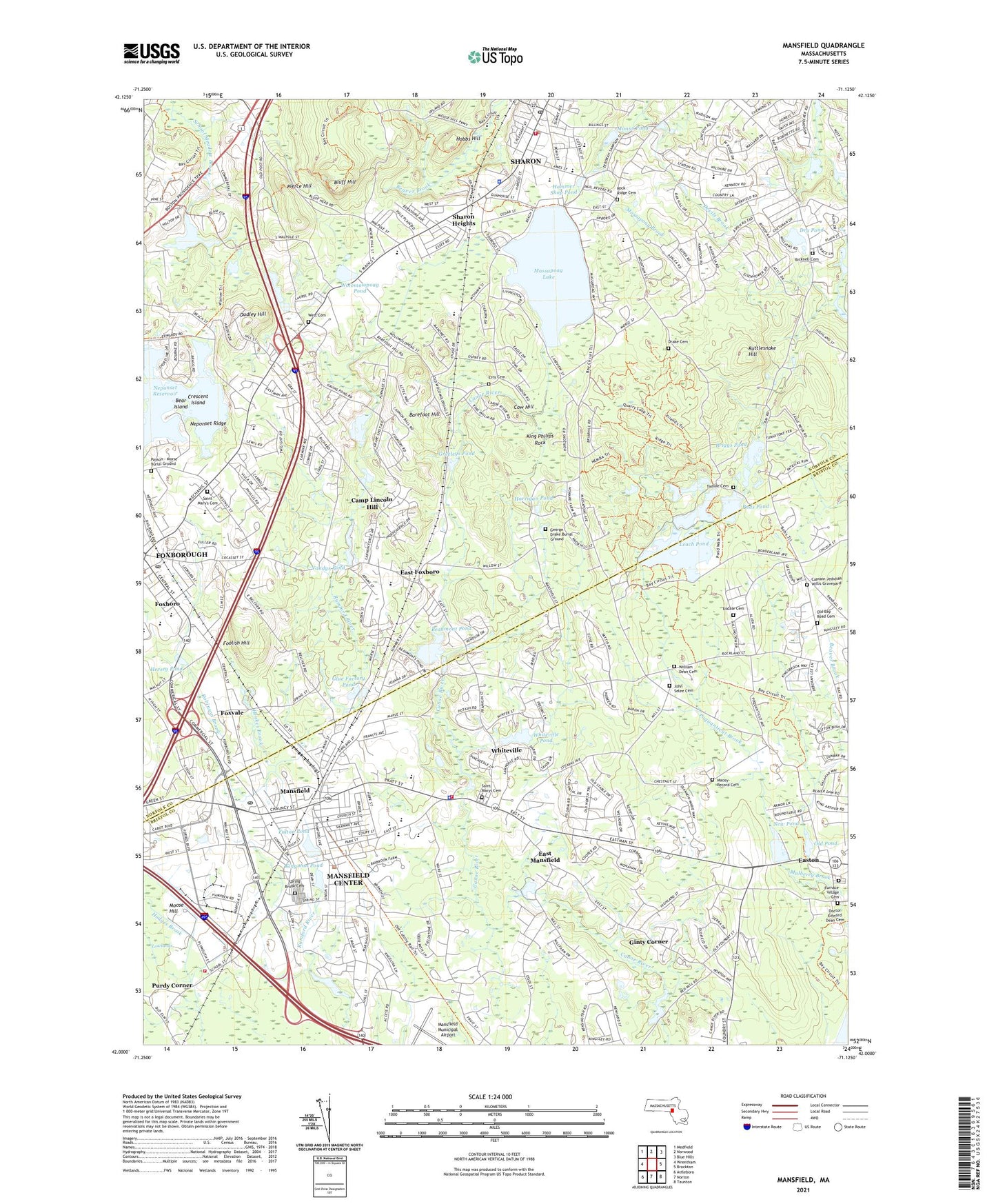
2024 topographic map quadrangle Mansfield in the state of Massachusetts. Scale: 1:24000. Based on the newly updated USGS 7.5' US Topo map series, this map is in the following counties: Norfolk, Bristol. The map contains contour data, water features, and other items you are used to seeing on USGS maps, but also has updated roads and other features. This is the next generation of topographic maps. Printed on high-quality waterproof paper with UV fade-resistant inks.
Quads adjacent to this one:
West: Wrentham
Northwest: Medfield
North: Norwood
Northeast: Blue Hills
East: Brockton
Southeast: Taunton
South: Norton
Southwest: Attleboro
Contains the following named places: Al-Noor Academy, Amego School, Ball Park, Barefoot Hill, Barrett School, Bear Island, Beaumont Pond, Beaver Brook, Bicknell Cemetery, Billings Brook, Bluff Hill, Borderland State Park, Bradlees Plaza Shopping Center, Briggs Pond, Cabot Pond, Camp Lincoln Hill, Camp Peter Pan, Camp Wonderland, Cards Pond, Carpenter School, Christian and Missionary Alliance Church, Cottage Street School, Cow Hill, Crescent Island, Devils Brook, Drake Cemetery, Dry Pond, Dudley Hill, East Elementary School, East Foxboro, East Mansfield, East Sharon School, Easton, Esty Cemetery, Evangelical Baptist Church, First Baptist Church, First Congregational Church, Foolish Hill, Foxboro, Foxboro Post Office, Foxboro Regional Charter School, Foxboro Seventh Day Adventist Church, Foxboro Shopping Center, Foxborough, Foxborough Census Designated Place, Foxborough High School, Foxfield Plaza, Foxvale, Fulton Pond, Gavins Pond, George Drake Burial Ground, Ginty Corner, Glue Factory Pond, Great Woods, Greeleys Pond, Green Elementary School, Hall School, Hammer Shop Pond, Harold L Qualters Middle School, Harrigan Pond, Hartwell School, Heights Elementary School, Henkes Brook, Hersey Pond, High Street School, Hobbs Hill, John J Ahern School, Jordan-Jackson Elementary School, King Philips Rock, Kingman Pond, Leach Pond, Lincoln Hill Camp, Mabelle M Burrell School, Manns Pond, Manns Pond Dam, Mansfield, Mansfield Center Census Designated Place, Mansfield Central School, Mansfield Fire Department Station 1 Headquarters, Mansfield Fire Department Station 2, Mansfield High School, Mansfield High School Library, Mansfield Library, Mansfield Memorial Park, Mansfield Municipal Airport, Mansfield Police Department, Mansfield Post Office, Mansfield Station, Massapoag Lake, Moose Hill, Moose Hill Wildlife Sanctuary, Muddy Pond, Neipris Library, Neponset Reservoir, Neponset Ridge, New Life Christian Center, New Pond, New Pond Dam, Old Pond, Old Pond Dam, Paine School, Park Row Elementary School, Payson - Morse Burial Ground, Pierce Hill, Pleasant Street School, Poquanticut Brook, Poquanticut School, Pratt School, Puds Pond, Purdy Corner, Rattlesnake Hill, Robinson Brook, Robinson Elementary School, Robinson Hill School, Rock Ridge Cemetery, Sacred Heart College, Saint Francis Retreat, Saint Gregory the Theologian Church, Saint Mary's Cemetery, Saint Marys Church, Sampson Park, Sharon, Sharon Ambulance Service, Sharon Census Designated Place, Sharon Country Club, Sharon Fire Department, Sharon Heights, Sharon Heights Shopping Center, Sharon High School, Sharon High School Library, Sharon Historic District, Sharon Middle School, Sharon Police Department, Sharon Post Office, Sharon Public Library, Sharon Shopping Center, Shaws Plaza Shopping Center, Spring Brook Cemetery, Sucker Brook, Temple Israel, The Sage School, Tisdale Cemetery, Town of Foxborough, Town of Mansfield, Town of Sharon, Union School, Unitarian Church of Sharon, Vandys Pond, West Cemetery, Whiteville, Whiteville Pond, Whiteville School, William E Lewis School, William R Lewis School, Willowdale Golf Club, Wolomolopoag Pond, Wolomolopoag Stolport, Zion Christian Assembly Church, ZIP Codes: 02035, 02048, 02067