MyTopo
Templeton Massachusetts US Topo Map
Couldn't load pickup availability
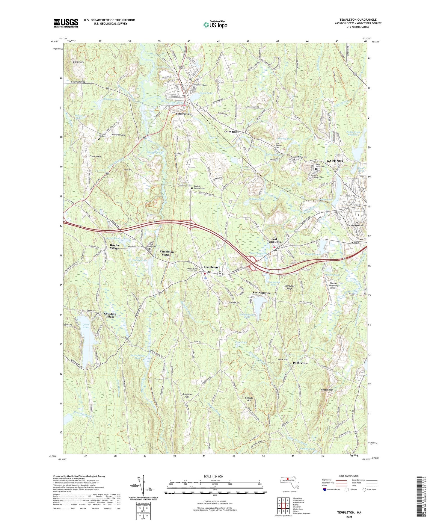
2021 topographic map quadrangle Templeton in the state of Massachusetts. Scale: 1:24000. Based on the newly updated USGS 7.5' US Topo map series, this map is in the following counties: Worcester. The map contains contour data, water features, and other items you are used to seeing on USGS maps, but also has updated roads and other features. This is the next generation of topographic maps. Printed on high-quality waterproof paper with UV fade-resistant inks.
Quads adjacent to this one:
West: Athol
Northwest: Royalston
North: Winchendon
Northeast: Ashburnham
East: Gardner
Southeast: Wachusett Mountain
South: Barre
Southwest: Petersham
Contains the following named places: Bailey Brook, Baldwin Water Supply Pond Dam, Baldwinville, Baldwinville Census Designated Place, Baldwinville Nursing Home, Baldwinville Post Office, Baldwinville School, Baldwinville Village Historic District, Baptist Common Cemetery, Beagle Pond, Beagle Pond Dam, Bennett Pond, Bethany Church, Betty Pond Dam, Bourn - Hadley Pond Dam, Bourn-Hadley Pond, Brazell Pond, Brooks Village, Burnshirt Hills, Canesto Hill, Church Hill, Church in the Wildewood, Coleman Street School, Cook Pond, Cottage Hill Academy, Crow Hill, Crow Hill Brook, Day Millpond, Demadale Ridge, Depot Pond, Dolbier Hill, East Templeton, East Templeton Middle School, East Templeton Pond, East Templeton Post Office, Elliott Hill, Fernald State School, Foster Brook, Gardner Chamber of Commerce, Gardner Junior High School, Gardner Municipal Airport, Gardner Sewage Disposal Plant, Gilman-Waite Field, Goulding Village, Greenlawn Cemetery, Greenwood Hill, Greenwood Playground, Greenwood Pond, Hansel Pond, Hilchey Pond, Hubbardston Brook, Hubbardston State Forest, Kendall Pond, Mine Hill, Narragansett Middle School, Narragansett Regional High School, Norcross Hill, Norcross Hill Brook, Norcross Hill Cemetery, Notre Dame Cemetery, Olivia Case Playground, Otter River, Otter River Dam, Otter River Reservoir, Otter River Sportsmens Club, Otter River State Forest, Parker Pond, Parker Pond Dam, Partidgeville, Partridgeville, Partridgeville Pond, Partridgeville Pond Dam, Perley Brook, Perley Brook Reservoir, Perley Brook Reservoir Dam, Pine Grove Cemetery, Pitcherville, Pond Brook, Queen Lake, Queen Lake Dam, Ragged Hill, Ridgerty Club, Ridgley Pond, Ridgley Pond Dam, Saint Johns Cemetery, Saint Josephs Cemetery, Saint Martins Church, Saint Vincent De Paul Church, Snake Pond, Stone Bridge Pond, Templeton, Templeton Brook, Templeton Census Designated Place, Templeton Center School, Templeton Common Historic District, Templeton Fire Department, Templeton Fire Department East Templeton, Templeton Fire Department Station 2 Headquarters, Templeton Fish and Gun Club, Templeton Land Fill, Templeton Police Department, Templeton Post Office, Templeton Sewer Plant, Templeton State Forest, Templeton Station, The Common, The Common School, Town of Templeton, Trout Brook, Waterford Street School, West Gardner Industrial Park, Wetmore Pond, Wetmore Pond Dam, Wilder Brook, Wilder Field, Wildwood Cemetery, Winchendon State Forest, Wine Brook, ZIP Codes: 01436, 01438, 01468