
MyTopo
Ashburnham Massachusetts US Topo Map
Couldn't load pickup availability
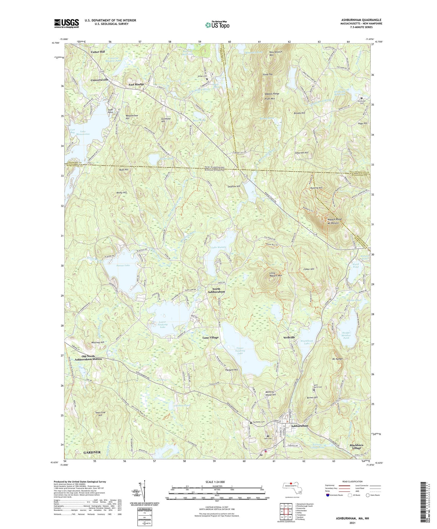
2024 topographic map quadrangle Ashburnham in the states of Massachusetts, New Hampshire. Scale: 1:24000. Based on the newly updated USGS 7.5' US Topo map series, this map is in the following counties: Worcester, Cheshire, Hillsborough, Middlesex. The map contains contour data, water features, and other items you are used to seeing on USGS maps, but also has updated roads and other features. This is the next generation of topographic maps. Printed on high-quality waterproof paper with UV fade-resistant inks.
Quads adjacent to this one:
West: Winchendon
Northwest: Monadnock Mountain
North: Peterborough South
Northeast: Greenville
East: Ashby
Southeast: Fitchburg
South: Gardner
Southwest: Templeton
Contains the following named places: Adams School, Ashburnham, Ashburnham Community Church, Ashburnham Fire Department Headquarters, Ashburnham Police Department, Ashburnham Post Office, Ashburnham State Forest, Ashburnham Town Hall, Bancroft Reservoir, Bancroft Reservoir Dam, Bear Meadow Brook, Bickford Field, Binney Hill, Binney Hill Brook, Binney Pond, Binney Pond State Forest, Blackburn Village, Bluefield Brook, Brown Brook, Brown Hill, Bush Hill, Camp Split Rock, Cheshire Pond, Christian Science Camp, Converse Meadow Pond, Converseville, Coot Bay, Cushing Academy, Cutter Hill, Divol Pond, East Rindge, Emerson Hill, Estees Brook, Factory Village Pond, Factory Village Pond Dam, Fairbanks Cemetery, Fisher Hill, Fox Brook, Griswold Hill, Hampshire Country School, Heritage Christian School, Island Pond, Jeffs Pond, Lake Monomonac, Lake Watatic, Lake Watatic Dam, Lane Village, Lincoln Pond, Little Watatic Mountain, Lower Naukeag Lake, Lower Naukeag Lake Dam, Marble Pond, Marble Pond Dam, Mclean Ambulatory Treatment Center at Naukeag, Meeting House Hill, Mill Pond, Mill Pond Dam, Mount Hunger, Mount Watatic, Mountain Pond, Mountain Pond Dam, New Cemetery, New Ipswich Mountain, North Ashburnham, Nutting Hill, Old North Ashburnham Station, Packard Hill, Page Hill, Pecker Pond, Peoples Congregational Church, Pratt Mountain, Pratt Pond, Pratt Pond Brook, Pratt Pond Dam, Rocky Hill, Saint Denis Cemetery, Smithville Cemetery, Smithville Reservoir, Souhegan River Watershed Dam Number 35, Stark Brook, Stevens Memorial Library, Stodge Meadow Pond, Stodge Meadow Pond Dam, Stony Top, Stump Pond, Stump Pond Dam, Sunset Lake, Sunset Lake Dam, Swallow Hill, Swan Point, Town Line Hill, Town of Ashburnham, Upper Naukeag Lake, Upper Naukeag Lake Dam, Wallace Pond, Wapack Range, Ward Pond, Watatic Mountain State Wildlife Area, Weatherbee Hill, Wellville, Whitemans Brook, Whitney Hill, Wilder Cemetery, Winnekeag Lake, Winnekeag Lake Dam, ZIP Code: 01430


