MyTopo
Winchendon Massachusetts US Topo Map
Couldn't load pickup availability
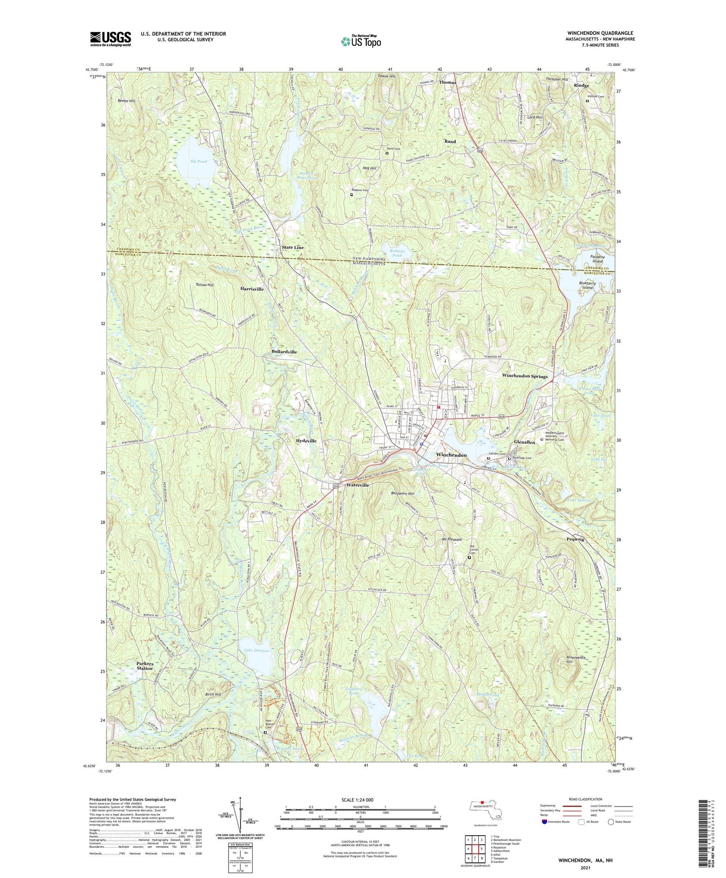
2024 topographic map quadrangle Winchendon in the states of Massachusetts, New Hampshire. Scale: 1:24000. Based on the newly updated USGS 7.5' US Topo map series, this map is in the following counties: Worcester, Cheshire. The map contains contour data, water features, and other items you are used to seeing on USGS maps, but also has updated roads and other features. This is the next generation of topographic maps. Printed on high-quality waterproof paper with UV fade-resistant inks.
Quads adjacent to this one:
West: Royalston
Northwest: Troy
North: Monadnock Mountain
Northeast: Peterborough South
East: Ashburnham
Southeast: Gardner
South: Templeton
Southwest: Athol
Contains the following named places: Bamans Pond Recreation Area, Beals Memorial Library, Beaman Brook, Beaman Pond, Beebe Hill, Benjamin Hill, Birch Hill, Birch Hill Dam, Birch Hill State Wildlife Management Area, Blueberry Island, Boy Scouts of America Camp Watalin Camping Area, Bullardville, Calvary Cemetery, Church of the Unity, Damon Mill Pond, Damon Mill Pond Dam, Damon Reservoirs, Damon Upper Reservoir, Damon Upper Reservoir Dam, Flis Pond, Flis Pond Dam, Glenallen, Harrisville, Hillside Cemetery, Hog Hill, Hunts Pond, Hunts Pond Dam, Hyde Park, Hydeville, Jones Corner, Lake Denison, Lake Jones, Lake Martin, Lake Monomonac Dam, Lake Sal, Lord Brook, Lord Hill, Marvin School, Massachusetts Veterans Memorial Cemetery, Mellen Pond, Memorial Elementary School, Mount Pleasant, Mud Pond, Murdock Middle High School, Murdock Middle-High School Library Media Center, New Boston, New Boston Cemetery, Nineteenth Hill, North Branch Millers River, Old Center Cemetery, Old Centre Historic District, Otter River, Paradise Island, Parkers Station, Pequoig, Poland School, Priest Brook, Rand, Rand Cemetery, Rindge Memorial School, Riverside Cemetery, Robbins Brook, Robbins Cemetery, Robbins Pond, Robbins Pond Dam, Royalston Community School, Scott Brook, Sip Pond, Sip Pond Brook, Spud Brook, State Line, Stoddard Pond, Stoddard Pond Dam, Streeter School, Tallow Hill, Tannery Pond, Tannery Pond Dam, Tarbell Brook, The Meeting School, Thomas, Thrasher Hill, Town of Winchendon, Towne Brook, Towne Hill, Toy Town Elementary, Tuckey School, V F W Park, Waterville, White School, Whites Mill Pond, Whites Mill Pond Dam, Whitney Pond, Whitney Pond Dam, Wichendon Shopping Center, Winchendon, Winchendon Ambulance Service, Winchendon Census Designated Place, Winchendon Center, Winchendon Country Club, Winchendon Fire Department, Winchendon Hospital, Winchendon Police Department, Winchendon Post Office, Winchendon School, Winchendon Shopping Center, Winchendon Springs, Winchendon Town Hall, WINQ-FM (Winchendon), Woodcock School, ZIP Code: 01475